Regions of Wisconsin
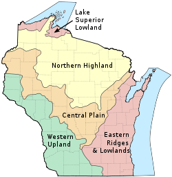
Wisconsin is historically divided into five geographical regions.[1]
Three of these geographical provinces are uplands and two are lowlands. These provinces are related to the use of the land by plants, by animals, and by man. Each differs from the others in roughness or smoothness of topography, infertility or sterility of soil, in climate, in adaptation to occupation by wild plants (including forests), by cultivated plants (including crops and orchards), by animals, and by man, as well as in the extent to which men have developed such resources during the march of Wisconsin history.
The boundaries of all five provinces are determined largely by the variations of texture and structure in the underlying rocks. The geographical regions have internal unity and significant contrast with neighboring regions in uses of the land by living things, including man.
References
Coordinates: 44°30′N 89°30′W / 44.5°N 89.5°W