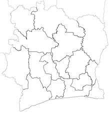
Regions of Ivory Coast
 |
| This article is part of a series on the politics and government of Ivory Coast |
|
|
Government |
|
| Foreign relations |
.jpg)
The regions of Ivory Coast (French: régions de Côte d'Ivoire) are the second-level subdivisions of Ivory Coast. There are 31 regions, and each region is subdivided into two or more departments, the third-level division in Ivory Coast. Two to four regions are combined to make up a district, the first-level subdivision. The two autonomous districts of Ivory Coast are not divided into regions.
History
The first 16 regions were established in 1997;[1] at the time, they supplanted the departments as the first-level administrative subdivisions of the country, with the departments being converted into second-level subdivisions. In 2000, four of the regions were divided to create three more regions, bringing the total to 19.
Prior to the 2011 reorganisation of the subdivisions of Ivory Coast, the 19 regions were the first-level subdivision of the country. In the reorganisation, districts were created and replaced regions as the first-level subdivisions and the 19 regions were reorganized into 30.[2][3] In 2012, one region was divided to create a 31st region.[4][5]
Governance and purpose
The executive of each region is headed by a prefect, who is appointed by the council of ministers (cabinet) of the national government.[6] For departments that house regional capitals, the prefect of the department is the same individual as the prefect of the region, though the two offices of prefect remain distinct.[7] The legislative body of the region is the Regional Council, which is elected and headed by a President.
The government of each region is responsible for designing and implementing programmes to improve the economic, social, and cultural life of the region.[6] Regions are also responsible for coordinating and harmonising the activities of their departmental governments and for implementing public interest projects established by the district or the national government.[6]
Precise distinctions in the jurisdiction of regions as compared to districts has yet to be established. The governments of the non-autonomous districts have not yet begun to function. Apart from governors for the two autonomous districts, no district governor has yet been nominated; the inaction has largely been in response to apprehensions by the regional prefects that district governors will usurp their authority and responsibilities.[8]
Regions
There are currently 31 regions of Ivory Coast. Two areas of the country, the autonomous districts of Abidjan and Yamoussoukro, are not divided into regions. The regions are as follows, with the date of creation in parentheses:
.png)
- Agnéby-Tiassa (2011)
- Bafing (2000)
- Bagoué (2011)
- Bélier (2011)
- Béré (2011)
- Bounkani (2011)
- Cavally (2011)
- Folon (2011)
- Gbêkê (2011)
- Gbôklé (2011)
- Gôh (2011)
- Gontougo (2011)
- Grands-Ponts (2011)
- Guémon (2011)
- Hambol (2011)
- Haut-Sassandra (1997)
- Iffou (2011)
- Indénié-Djuablin (2011)
- Kabadougou (2011)
- La Mé (2011)
- Lôh-Djiboua (2011)
- Marahoué (1997)
- Moronou (2012)
- Nawa (2011)
- N'Zi (2011)
- Poro (2011)
- San-Pédro (2011)
- Sud-Comoé (1997)
- Tchologo (2011)
- Tonkpi (2011)
- Worodougou (1997)
- A. Abidjan Autonomous District (2011) (not a region or divided into regions)
- B. Yamoussoukro Autonomous District (2011) (not a region or divided into regions)
The 14 districts (of which two are autonomous and are not subdivided into regions) and the 31 regions are listed below, with their regional seats and populations at the 2014 census.[9]
| District | District capital | Regions | Region seat | Population |
|---|---|---|---|---|
| Abidjan (District Autonome d'Abidjan) |
4,707,404 | |||
| Bas-Sassandra (District du Bas-Sassandra) |
San-Pédro | Gbôklé | Sassandra | 400,798 |
| Nawa | Soubré | 1,053,084 | ||
| San-Pédro | San-Pédro | 826,666 | ||
| Comoé (District du Comoé) |
Abengourou | Indénié-Djuablin | Abengourou | 560,432 |
| Sud-Comoé | Aboisso | 642,620 | ||
| Denguélé (District du Denguélé) |
Odienné | Folon | Minignan | 96,415 |
| Kabadougou | Odienné | 193,364 | ||
| Gôh-Djiboua (District du Gôh-Djiboua) |
Gagnoa | Gôh | Gagnoa | 876,117 |
| Lôh-Djiboua | Divo | 729,169 | ||
| Lacs (District des Lacs) |
Dimbokro | Bélier | Yamoussoukro[10] | 346,768 |
| Iffou | Daoukro | 311,642 | ||
| Moronou | Bongouanou | 352,616 | ||
| N'Zi | Dimbokro | 247,578 | ||
| Lagunes (District des Lagunes) |
Dabou | Agnéby-Tiassa | Agboville | 606,852 |
| Grands-Ponts | Dabou | 356,495 | ||
| La Mé | Adzopé | 514,700 | ||
| Montagnes (District des Montagnes) |
Man | Cavally | Guiglo | 459,964 |
| Guémon | Duékoué | 919,392 | ||
| Tonkpi | Man | 992,564 | ||
| Sassandra-Marahoué (District du Sassandra-Marahoué) |
Daloa | Haut-Sassandra | Daloa | 1,430,960 |
| Marahoué | Bouaflé | 862,344 | ||
| Savanes (District des Savanes) |
Korhogo | Bagoué | Boundiali | 375,687 |
| Poro | Korhogo | 763,852 | ||
| Tchologo | Ferkessédougou | 467,958 | ||
| Vallée du Bandama (District de la Vallée du Bandama) |
Bouaké | Gbêkê | Bouaké | 1,010,849 |
| Hambol | Katiola | 429,977 | ||
| Woroba (District du Woroba) |
Séguéla | Béré | Mankono | 389,758 |
| Bafing | Touba | 183,047 | ||
| Worodougou | Séguéla | 272,334 | ||
| Yamoussoukro (District Autonome du Yamoussoukro) |
355,573 | |||
| Zanzan (District du Zanzan) |
Bondoukou | Bounkani | Bouna | 267,167 |
| Gontougo | Bondoukou | 667,185 | ||
Regions before 2011

Before a reorganization in 2011, the regions were the first-level subdivisions of Ivory Coast. The 19 regions that existed immediately prior to the reorganisation were as follows, with their creation date in parentheses:[11]
- Agnéby (1997)
- Bafing (2000)
- Bas-Sassandra (1997)
- Denguélé (1997)
- Dix-Huit Montagnes (1997)
- Fromager (2000)
- Haut-Sassandra (1997)
- Lacs (1997)
- Lagunes (1997)
- Marahoué (1997)
- Moyen-Cavally (2000)
- Moyen-Comoé (1997)
- N'Zi-Comoé (1997)
- Savanes (1997)
- Sud-Bandama (1997)
- Sud-Comoé (1997)
- Vallée du Bandama (1997)
- Worodougou (1997)
- Zanzan (1997)
As is the case now, regions were further divided into departments. From 1997 to 2011, departments were the second-level administrative subdivisions.
See also
References
- ↑ In the 1980s, ten regions were set up as regional groupings for census purposes, but these "regions" were not administrative subdivisions of the country and existed only for statistical purposes.
- ↑ "Décentralisation : Le gouvernement créé 12 districts et 30 régions", abidjan.net, 29 September 2011.
- ↑ Décret n° 2011-263 du 28 septembre 2011 portant organisation du territoire national en Districts et en Régions.
- ↑ "Conseil des Ministres du mercredi 04 Juillet 2012 : De nouvelles entités administratives créées", abidjan.net, 5 July 2012.
- ↑ Décret n° 2012-612 du 04 juillet 2012 portant création de la Région du Moronou.
- 1 2 3 Loi n° 2014-451 du 5 août 2014 portant orientation de l'organisation générale de l'Administration Territoriale.
- ↑ Ordonnance n° 2011-262 du 28 septembre 2011 portant orientation de l'organisation générale de l'administration territoriale de l'Etat.
- ↑ "Les chefs de San Pedro demandent l’érection de leur cité en district autonome", 8 March 2015.
- ↑ "Districts of Côte d'Ivoire". Statoids. Institut National de la Statistique, Côte d'Ivoire.
- ↑ While Yamoussoukro is the seat of Bélier region, the city itself is not part of the region.
- ↑ "Regions of Côte d'Ivoire". Statoids.
.jpg)