Redland, Oklahoma
Redland is an unincorporated community in Sequoyah County, Oklahoma located three miles southwest of Muldrow, Oklahoma. The community covers a wide area that is bounded on the north by Big Skin Creek, to the east by both Little Skin Bayou and Big Skin Creek, to the south by the Arkansas River, with an undefined border to the west near Gans, Oklahoma.
A very old and significant community. It was inhabited by prehistoric Native Americans and European traders who followed the Arkansas River west from the Mississippi River. The land north and south of the Arkansas River are both known as the Redland Bottoms, extending about four miles to the southeast to old Fort Coffee, near Spiro, Oklahoma. Also on the southeast side of the Redland Bottoms are the Spiro Mounds. This was the ceremonial center of activity for a tribe of prehistoric Indian Mound builders. They lived in the Redland Bottoms, on both sides of the river, for a lengthy period in Oklahoma's prehistory.
In the early 1800s, Cherokee Indians were relocated here and this area became a part of the Cherokee Nation. With the growth in population, a steamboat stop was located at Redland on the north bank of the Arkansas River. Several years later, the railroad built a line through Redland and bridge to cross the river. A depot was established near the bridge, with trains traveling north to Missouri and south to Texas. The steam trains frequently stopped at the Redland depot, before and after crossing the Redland bridge, to re-load on coal and water. The original bridge was a long, low wooden-trestle type bridge, it was lost to flooding many times over the years.
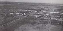
With the combination of train traffic and riverboat traffic, Redland station became a local supply point and by 1890, a small town began to develop. It had a few stores, a school, churches, a post office, blacksmiths, mills, and a handful of homes. However, like the railroad bridge, the town itself was subject to flooding. A series of devastating floods in the 1940s wiped out the town from which it never recovered. With the increased use of diesel trains, the train depot was no longer needed and it was inactivated in the 1950s. As a result, what little that was left of the town faded from existence, with only a cemetery and a few foundations remaining.
Today, the Redland community consists of cattle ranches, crop farms, churches and rural/suburban type homes. Law enforcement is proivided by the Sequoyah County Sheriff's Office. Fire protection is provided by the Redland Fire Department, which has a fire station near the original townsite.
Coordinates: 35°18′18″N 94°37′26″W / 35.305°N 94.624°W