Red Lodge, Montana
| Red Lodge, Montana | |
|---|---|
| City | |
|
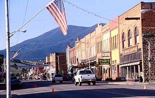
Main Street in Red Lodge | |
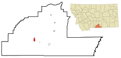 Location of Red Lodge, Montana | |
| Coordinates: 45°11′15″N 109°14′55″W / 45.18750°N 109.24861°WCoordinates: 45°11′15″N 109°14′55″W / 45.18750°N 109.24861°W | |
| Country | United States |
| State | Montana |
| County | Carbon |
| Area[1] | |
| • Total | 2.80 sq mi (7.25 km2) |
| • Land | 2.80 sq mi (7.25 km2) |
| • Water | 0 sq mi (0 km2) |
| Elevation | 5,568 ft (1,697 m) |
| Population (2010)[2] | |
| • Total | 2,125 |
| • Estimate (2015)[3] | 2,222 |
| • Density | 758.9/sq mi (293.0/km2) |
| Time zone | Mountain (MST) (UTC-7) |
| • Summer (DST) | MDT (UTC-6) |
| ZIP code | 59068 |
| Area code(s) | 406 |
| FIPS code | 30-61525 |
| GNIS feature ID | 0789456 |
| Website | cityofredlodge.net |
Red Lodge is a city in and the county seat of Carbon County, Montana, United States.[4] It is part of the Billings Metropolitan Statistical Area. The population was 2,125 at the United States Census, 2010.[5]
Geography
Red Lodge is located at 45°11′15″N 109°14′55″W / 45.18750°N 109.24861°W (45.187515, -109.248475).[6]
According to the United States Census Bureau, the city has a total area of 2.80 square miles (7.25 km2), all of it land.[1]
History
On September 17, 1851, the United States government signed a treaty with the Crow Nation, ceding the area which now contains Red Lodge to the Crow Indians. Rich coal deposits were found there in 1866, and gold was discovered nearby in 1870. An 1880 treaty between the U.S. government and the Crow allowed the area to be settled starting April 11, 1882.[7]
The Red Lodge post office was established on Dec 9, 1884 with Postmaster Ezra L. Benton.[8] A rail line was constructed into town, and coal shipments began in June 1889. The boundaries of the Crow Reservation were redrawn October 15, 1892, opening the whole area to settlement. From then until the 1930s, coal mining defined the town.[9]
In the late 19th century, many new settlers came to Red Lodge. The majority came from Italy, Scotland, Wales, England, Finland, Norway, Sweden, Germany, and Austria-Hungary. By the mid-1880s, migrants were still outnumbered by large numbers of Native Americans. By 1892 the population reached 1,180.
In 1896, Red Lodge had twenty saloons and, as the library records show, riotous and violent living was characteristic of the town. By 1906 the population had grown to 4,000 and by 1911 this had increased to 5,000.
Red Lodge suffered in the Great Depression, which forced many mines to close. To offset this downturn, the manufacture of illegal bootleg liquor, labeled syrup, became an economic mainstay and was sold as far away as Chicago and San Francisco.
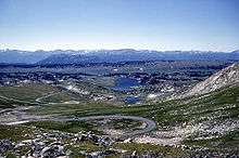
In 1931 work began on the Beartooth Highway[10][11] linking Red Lodge to Yellowstone National Park; it was officially opened in 1936.
The downtown has been redeveloped since the mid-1980s for historic and cultural tourism, as the Red Lodge Commercial Historic District. The buildings in downtown Red Lodge had fallen into disrepair, in large part because population had dropped from its 1915 peak of 6000 people to about 2,000.[12]
As of 2006, an estimate suggests that the population of Red Lodge may increase from about 1,200 people in the winter to over 1,800 people during the summer tourist season, arriving via the Beartooth Highway.
Government
Red Lodge is the county seat of Carbon County. Red Lodge is an incorporated city, governed via the mayor/council system. There are six members of the city council, elected from one of three wards of roughly equal population. There are two council members from each ward. The mayor is elected in a citywide vote.
Outdoor recreation

Red Lodge is well known for many outdoor recreation opportunities: skiing, mountain biking, and backpacking are nearby. In April it is host to a popular triathlon called the Peaks to Prairie.
Educational institutions
The Yellowstone Bighorn Research Association's Geology Field Station is located south of Red Lodge.[13]
Media
Radio
- KMXE FM 99.3
Newspapers
- Carbon County News (Weekly)
- The Local Rag (Monthly)
- Red Lodge Pickett (1892-1922)[14]
- Red Lodge Pickett-Journal
Climate
Red Lodge experiences a continental climate (Köppen Dfb) with cold, somewhat dry winters and warm, wetter summers. Summers are cooler than in areas of Montana further north, due to the high elevation. Winters however, are milder than areas further to the east due to the chinook wind influence, as with most of Montana.
| Climate data for Red Lodge, Montana | |||||||||||||
|---|---|---|---|---|---|---|---|---|---|---|---|---|---|
| Month | Jan | Feb | Mar | Apr | May | Jun | Jul | Aug | Sep | Oct | Nov | Dec | Year |
| Record high °F (°C) | 70 (21) |
70 (21) |
72 (22) |
80 (27) |
88 (31) |
96 (36) |
101 (38) |
96 (36) |
92 (33) |
86 (30) |
80 (27) |
71 (22) |
101 (38) |
| Average high °F (°C) | 34.1 (1.2) |
37.4 (3) |
43.9 (6.6) |
52.7 (11.5) |
61.9 (16.6) |
71.7 (22.1) |
79.2 (26.2) |
79.1 (26.2) |
68.6 (20.3) |
56.7 (13.7) |
41.7 (5.4) |
35.5 (1.9) |
55.21 (12.89) |
| Daily mean °F (°C) | 23.0 (−5) |
26.5 (−3.1) |
32.5 (0.3) |
40.7 (4.8) |
49.5 (9.7) |
57.9 (14.4) |
64.3 (17.9) |
63.8 (17.7) |
54.3 (12.4) |
44.2 (6.8) |
31.0 (−0.6) |
24.5 (−4.2) |
42.68 (5.93) |
| Average low °F (°C) | 11.8 (−11.2) |
15.5 (−9.2) |
21.0 (−6.1) |
28.6 (−1.9) |
37.0 (2.8) |
44.1 (6.7) |
49.3 (9.6) |
48.5 (9.2) |
40.0 (4.4) |
31.7 (−0.2) |
20.2 (−6.6) |
13.4 (−10.3) |
30.09 (−1.07) |
| Record low °F (°C) | −38 (−39) |
−42 (−41) |
−30 (−34) |
−10 (−23) |
7 (−14) |
25 (−4) |
30 (−1) |
22 (−6) |
8 (−13) |
−13 (−25) |
−25 (−32) |
−42 (−41) |
−42 (−41) |
| Average precipitation inches (mm) | 1.31 (33.3) |
1.06 (26.9) |
2.27 (57.7) |
2.88 (73.2) |
3.96 (100.6) |
2.56 (65) |
1.69 (42.9) |
1.37 (34.8) |
2.12 (53.8) |
2.04 (51.8) |
1.38 (35.1) |
1.13 (28.7) |
23.77 (603.8) |
| Average snowfall inches (cm) | 15.0 (38.1) |
13.9 (35.3) |
22.1 (56.1) |
21.0 (53.3) |
8.0 (20.3) |
0.5 (1.3) |
0 (0) |
0 (0) |
3.7 (9.4) |
11.7 (29.7) |
13.6 (34.5) |
13.8 (35.1) |
124.8 (317) |
| Source #1: NOAA (normals, 1971–2000) [15] | |||||||||||||
| Source #2: The Weather Channel (Records) [16] | |||||||||||||
Notable residents
- Brady Canfield, Bronze medal winner in the 2003 FIBT World Championships in skeleton racing
- John "Liver-Eating" Johnston was elected the first marshal in Red Lodge in 1888.[17]
- Laurie Niemi, Washington Redskins offensive tackle
- Gary D. Robson, author and closed captioning innovator
- Emily E. Sloan, lawyer, author
- K. Ross Toole, noted Montana historian

Smith Mine disaster
In 1943 tragedy hit Smith Mine #3 near Bearcreek, the area's largest remaining mine.[18] An explosion trapped and killed 74 men - only three of the workers that were in the mine that day escaped. This was the worst coal mine disaster in Montana's history. The mines were shut down forever shortly thereafter. The Red Lodge cemetery contains a memorial. This mine was reopened in the late 1970s.
Demographics
| Historical population | |||
|---|---|---|---|
| Census | Pop. | %± | |
| 1890 | 624 | — | |
| 1900 | 2,152 | 244.9% | |
| 1910 | 4,860 | 125.8% | |
| 1920 | 4,515 | −7.1% | |
| 1930 | 3,026 | −33.0% | |
| 1940 | 2,950 | −2.5% | |
| 1950 | 2,730 | −7.5% | |
| 1960 | 2,278 | −16.6% | |
| 1970 | 1,844 | −19.1% | |
| 1980 | 1,896 | 2.8% | |
| 1990 | 1,958 | 3.3% | |
| 2000 | 2,177 | 11.2% | |
| 2010 | 2,125 | −2.4% | |
| Est. 2015 | 2,222 | [19] | 4.6% |
| source:[20] 2015 Estimate[3] | |||
2010 census
As of the census[2] of 2010, there were 2,125 people, 1,082 households, and 513 families residing in the city. The population density was 758.9 inhabitants per square mile (293.0/km2). There were 1,675 housing units at an average density of 598.2 per square mile (231.0/km2). The racial makeup of the city was 96.3% White, 0.4% African American, 0.6% Native American, 0.3% Asian, 0.1% Pacific Islander, 0.6% from other races, and 1.6% from two or more races. Hispanic or Latino of any race were 1.9% of the population.
There were 1,082 households of which 19.5% had children under the age of 18 living with them, 35.6% were married couples living together, 8.2% had a female householder with no husband present, 3.6% had a male householder with no wife present, and 52.6% were non-families. 43.8% of all households were made up of individuals and 14.4% had someone living alone who was 65 years of age or older. The average household size was 1.92 and the average family size was 2.62.
The median age in the city was 47.3 years. 16.8% of residents were under the age of 18; 6.4% were between the ages of 18 and 24; 22.8% were from 25 to 44; 34.4% were from 45 to 64; and 19.8% were 65 years of age or older. The gender makeup of the city was 49.4% male and 50.6% female.
2000 census
As of the census[22] of 2000, there were 2,177 people, 1,020 households, and 528 families residing in the city. The population density was 846.0 people per square mile (327.1/km²). There were 1,415 housing units at an average density of 549.9 per square mile (212.6/km²). The racial makeup of the city was 96.14% White, 0.41% African American, 1.10% Native American, 0.46% Asian, 0.46% from other races, and 1.42% from two or more races. Hispanic or Latino of any race were 1.98% of the population.
There were 1,020 households out of which 22.8% had children under the age of 18 living with them, 41.3% were married couples living together, 7.3% had a female householder with no husband present, and 48.2% were non-families. 39.8% of all households were made up of individuals and 15.0% had someone living alone who was 65 years of age or older. The average household size was 2.04 and the average family size was 2.76.
In the city the population was spread out with 20.2% under the age of 18, 6.9% from 18 to 24, 28.6% from 25 to 44, 24.9% from 45 to 64, and 19.4% who were 65 years of age or older. The median age was 42 years. For every 100 females there were 93.5 males. For every 100 females age 18 and over, there were 88.9 males.
The median income for a household in the city was $31,750, and the median income for a family was $40,260. Males had a median income of $30,250 versus $20,208 for females. The per capita income for the city was $19,090. About 6.9% of families and 9.7% of the population were below the poverty line, including 12.4% of those under age 18 and 9.3% of those age 65 or over.
Schools
Red Lodge is served by three public schools: Mountain View Elementary School, Roosevelt Middle School, and Red Lodge High School.[23]
References
- 1 2 "US Gazetteer files 2010". United States Census Bureau. Retrieved 2012-12-18.
- 1 2 "American FactFinder". United States Census Bureau. Retrieved 2012-12-18.
- 1 2 "Population Estimates". United States Census Bureau. Retrieved July 19, 2016.
- ↑ "Find a County". National Association of Counties. Archived from the original on 2011-05-31. Retrieved 2011-06-07.
- ↑ American FactFinder - Results Archived August 15, 2014, at the Wayback Machine.
- ↑ "US Gazetteer files: 2010, 2000, and 1990". United States Census Bureau. 2011-02-12. Retrieved 2011-04-23.
- ↑ Blevins, Bruce. An Early History of Red Lodge, Montana. WIM: Powell, 1988, 3-6. No ISBN.
- ↑ Lutz, Dennis. Montana Post Offices and Postmasters. Rochester: Johnson, 1986, 41. No ISBN.
- ↑ Christensen, Bonnie. Red Lodge and the Mythic West. Lawrence: U of Kansas P, 2000, xii. ISBN 978-0-7006-1198-0
- ↑ Blevins, Bruce H. Beartooth Highway Experiences. Powell: WIM, 2003. ISBN 1-893771-07-5.
- ↑ , Public Roads, July/August 2006, v.70, No.1. Retrieved 20 October 2014.
- ↑ Michels Raffety Architects (1986). Red Lodge commercial historic district : revitalization master plan. Carbon County Historic Preservation Office. Retrieved 2014-02-06.
- ↑ Yellowstone Bighorn Research Association Homepage
- ↑ National Register of Historic Places Form, Hi Bug Historic District, accessed October 25, 2016 at https://mhs.mt.gov/Portals/11/shpo/docs/HiBugHD(BoundaryDecrease).pdf
- ↑ "Climatography of the United States NO.81" (PDF). National Oceanic and Atmospheric Administration. Retrieved January 15, 2011.
- ↑ "Monthly Averages for Red Lodge, MT". The Weather Channel. Retrieved January 15, 2011.
- ↑ Crow Killer: The Saga of Liver-Eating Johnson, by Raymond W. Thorpe and Robert Bunker (1983) pg 188. ISBN 978-0-253-20312-0
- ↑ The Darkest Hour: A Comprehensive Account of the Smith Mine Disaster of 1943, 2nd ed, by Gary D. Robson and Fay Kuhlman (2003). ISBN 0-9659609-1-9
- ↑ "Annual Estimates of the Resident Population for Incorporated Places: April 1, 2010 to July 1, 2015". Retrieved July 2, 2016.
- ↑ Moffatt, Riley. Population History of Western U.S. Cities & Towns, 1850-1990. Lanham: Scarecrow, 1996, 134.
- ↑ "Census of Population and Housing". Census.gov. Archived from the original on May 11, 2015. Retrieved July 19, 2016.
- ↑ "American FactFinder". United States Census Bureau. Archived from the original on 2013-09-11. Retrieved 2008-01-31.
- ↑ "Red Lodge Public Schools".
External links
| Wikimedia Commons has media related to RedLodge, Montana. |
-
 Red Lodge travel guide from Wikivoyage
 - City website
- Red Lodge Area Chamber of Commerce
Municipalities and communities of Carbon County, Montana, United States | ||
|---|---|---|
| City | 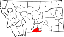 | |
| Towns | ||
| CDPs | ||
| Other unincorporated communities | ||