Rawsonville
| Rawsonville | |
|---|---|
|
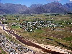
Aerial view of Rawsonville and the Smalblaar River, looking towards Du Toitskloof Pass to the west | |
 Rawsonville  Rawsonville  Rawsonville
| |
| Coordinates: 33°41′4.9″S 19°18′54″E / 33.684694°S 19.31500°ECoordinates: 33°41′4.9″S 19°18′54″E / 33.684694°S 19.31500°E | |
| Country | South Africa |
| Province | Western Cape |
| District | Cape Winelands |
| Municipality | Breede Valley |
| Government | |
| • Type | Ward 20 |
| Area[1] | |
| • Total | 2.42 km2 (0.93 sq mi) |
| Elevation | 223 m (732 ft) |
| Population (2011)[1] | |
| • Total | 3,099 |
| • Density | 1,300/km2 (3,300/sq mi) |
| Racial makeup (2011)[1] | |
| • Black African | 8.5% |
| • Coloured | 66.8% |
| • Indian/Asian | 0.2% |
| • White | 23.9% |
| • Other | 0.6% |
| First languages (2011)[1] | |
| • Afrikaans | 95.2% |
| • Xhosa | 1.7% |
| • English | 1.5% |
| • Other | 1.5% |
| Postal code (street) | 6845 |
| PO box | 6845 |
| Area code | 023 |
| Website | www.breedekloof.co.za |
Rawsonville is a small wine growing and farming community in the Breede River Valley of the Western Cape province of South Africa. The town forms part of the Breede Valley Local Municipality, and is located in a scenic portion of the valley on the eastern flanks of the Du Toitskloof Mountains.
The climate is hinterland (further from oceanic influences) Mediterranean, with cool, rainy winters and warm, dry summers. Due to its more inland location, winters can sometimes get frosty, with heavy snowfalls sometimes falling on the surrounding high-ground, summers are generally pleasant, although some February and March days can reach 38°C or higher.
The area is known for the Breedekloof Wine Route with its 22 Cellars and Wine Estates and also hosts the annual Breedekloof extreme sports festival. The economy remains heavily reliant on serving the agricultural community, however tourism in the form of weekend retreats are becoming more important to the town's income. Rawsonville is 90 km to the east of Cape Town and 15 km to the west of the large town of Worcester.
Early history
Old Goudini Farms
Slanghoek, Klipdrift, Groot Vlakte, Groot Eiland, Gevonden, Goudyn, Boontjiesrivier, Dasbosch Rivier, Pokkekraal and Aan-de-Smalblaar were some of the original farms occupied by European settlers since 1709.
Town
By the 1850s the necessity for the formation of a hamlet had become clear; the ward was cut off from Worcester during the rainy season when the Breede River burst it banks regularly.
The farm Aan-de-Smalblaar was transported to Johannes Petrus (Jan) Jordaan on the 23rd of July 1858. Jan Jordaan divided a portion of the farm into 57 residential plots and these were sold at a Public Auction on 11 June 1859. The town was named for William Rawson, the Cape Colonial Secretary. Since the modern day, there are a rural suburb area called De Nova and squatter camps called spookytown and geelkampies.
School and Church
45 “Deelhebbers” (participants) decided to form “De Goudini School” in 1858 and they were represented by seven School Directors. On 16 June 1878 a public meeting was held to ascertain if a Dutch Reformed Church Congregation should be established at Rawsonville and on 14 October 1879 the Worcester Ring Commission granted permission for the formation of the Goudini Dutch Reformed Congregation. Rawsonville also consist of schools called Rawsonville Primary, Weltevrede Primary and many more.
Town Management
Under the Village Management Act Rawsonville was granted Town Management in 1883. During the 1800s, if a doctor was needed someone had to travel to Worcester on horseback or on foot and if it rained continually for six hours, the Smalblaar River burst its banks and the water ran through town. Under these circumstances no school was attended.
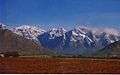 Vineyards and the Slanghoek Mountains outside Rawsonville
 Rawsonville beneath Du Toitskloof Mountains
 View of Rawsonville village, with Goudini Sneeukop mountain (nicknamed sneeukoppie)beyond
References
- 1 2 3 4 "Main Place Rawsonville". Census 2011.
- Eeublad; WR Laubscher; Hoërskool Goudini 1958
- Genade genoeg vir Goudini; AP Smit; Kerkraad 1979
Municipalities and communities of Cape Winelands District Municipality, Western Cape | ||
|---|---|---|
District seat: Stellenbosch | ||
| Witzenberg | .svg.png) | |
| Drakenstein | ||
| Stellenbosch | ||
| Breede Valley | ||
| Langeberg | ||