Rangsdorf
| Rangsdorf | ||
|---|---|---|
| ||
 Rangsdorf | ||
Location of Rangsdorf within Teltow-Fläming district  | ||
| Coordinates: 52°16′59″N 13°25′59″E / 52.28306°N 13.43306°ECoordinates: 52°16′59″N 13°25′59″E / 52.28306°N 13.43306°E | ||
| Country | Germany | |
| State | Brandenburg | |
| District | Teltow-Fläming | |
| Government | ||
| • Mayor | Klaus Rocher (FDP) | |
| Area | ||
| • Total | 33.72 km2 (13.02 sq mi) | |
| Population (2015-12-31)[1] | ||
| • Total | 10,848 | |
| • Density | 320/km2 (830/sq mi) | |
| Time zone | CET/CEST (UTC+1/+2) | |
| Postal codes | 15834 | |
| Dialling codes | 033708 | |
| Vehicle registration | TF | |
| Website | www.gemeinde-rangsdorf.de | |

Rangsdorf is a municipality in the district of Teltow-Fläming in Brandenburg in Germany. It has an airfield [up to 1940 a genuine commercial airport] from where on 20 July 1944 Claus Schenk Graf von Stauffenberg took off on his fateful attempt to assassinate German leader Adolf Hitler at his military headquarters in East Prussia, the Wolfsschanze.
Demography
 Development of Population since 1875 within Current Boundaries (Blue Line: Population; Dotted Line: Comparison to Population Development of Brandenburg state; Grey Background: Time of National Socialist rule; Red Background: Time of Communist rule)
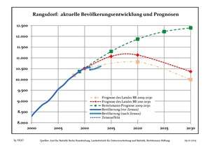 Recent Population Development (Blue Line) and Forecasts
References
Towns and municipalities in Teltow-Fläming | ||
|---|---|---|
This article is issued from Wikipedia - version of the 12/12/2015. The text is available under the Creative Commons Attribution/Share Alike but additional terms may apply for the media files.