Ramona, Kansas
| Ramona, Kansas | |
|---|---|
| City | |
 Location within Marion County and Kansas | |
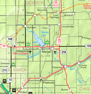 KDOT map of Marion County (legend) | |
| Coordinates: 38°35′51″N 97°3′46″W / 38.59750°N 97.06278°WCoordinates: 38°35′51″N 97°3′46″W / 38.59750°N 97.06278°W[1] | |
| Country | United States |
| State | Kansas |
| County | Marion |
| Platted | 1887 |
| Incorporated | 1909 |
| Government | |
| • Type | Mayor–Council |
| • Mayor | Byron Noeth [2] |
| • City Clerk | Jessica Gilbert [2] |
| Area[3] | |
| • Total | 0.31 sq mi (0.80 km2) |
| • Land | 0.31 sq mi (0.80 km2) |
| • Water | 0 sq mi (0 km2) |
| Elevation[1] | 1,421 ft (433 m) |
| Population (2010)[4] | |
| • Total | 187 |
| • Estimate (2015)[5] | 179 |
| • Density | 600/sq mi (230/km2) |
| Time zone | CST (UTC-6) |
| • Summer (DST) | CDT (UTC-5) |
| ZIP code | 67475 |
| Area code | 785 |
| FIPS code | 20-58375 [1] |
| GNIS feature ID | 0477133 [1] |
| Website |
RamonaKS |
|
| |
Ramona is a city in Marion County, Kansas, United States.[1][6] As of the 2010 census, the city population was 187.[7]
History

Early history
For many millennia, the Great Plains of North America was inhabited by nomadic Native Americans. From the 16th century to 18th century, the Kingdom of France claimed ownership of large parts of North America. In 1762, after the French and Indian War, France secretly ceded New France to Spain, per the Treaty of Fontainebleau.
19th century
In 1802, Spain returned most of the land to France. In 1803, most of the land for modern day Kansas was acquired by the United States from France as part of the 828,000 square mile Louisiana Purchase for 2.83 cents per acre.
In 1854, the Kansas Territory was organized, then in 1861 Kansas became the 34th U.S. state. In 1855, Marion County was established within the Kansas Territory, which included the land for modern day Ramona.[8]
The city name Ramona is a Spanish name. Land ownership of the Ramona area dates back when the area belonged to Spain. Manuel De Lisa, a New Orleans merchant, petitioned his government for a large land grant in the Ramona area on July 16, 1799.[9]
In 1887, the Chicago, Kansas and Nebraska Railway built a main line from Herington through Ramona to Pratt.[10] In 1888, this line was extended to Liberal. Later, it was extended to Tucumcari, New Mexico and El Paso, Texas. It foreclosed in 1891 and taken over by Chicago, Rock Island and Pacific Railway, which shut down in 1980 and reorganized as Oklahoma, Kansas and Texas Railroad, merged in 1988 with Missouri Pacific Railroad, and finally merged in 1997 with Union Pacific Railroad. Most locals still refer to this railroad as the "Rock Island".
A post office was established in Ramona on August 9, 1887.[11]
21st century
In 2010, the Keystone-Cushing Pipeline (Phase II) was constructed near Ramona, north to south through Marion County, with much controversy over road damage, tax exemption, and environmental concerns (if a leak ever occurs).[12][13][14]
Geography
Ramona is located at 38°35′51″N 97°3′46″W / 38.59750°N 97.06278°W (38.597448, -97.062864).[1] According to the United States Census Bureau, the city has a total area of 0.31 square miles (0.80 km2), all of it land.[3] The county line is 0.5 miles north of Ramona.
Area events
- July 4th Celebration, the event is named "RedNeck in Ramona".
Demographics
| Historical population | |||
|---|---|---|---|
| Census | Pop. | %± | |
| 1910 | 265 | — | |
| 1920 | 303 | 14.3% | |
| 1930 | 240 | −20.8% | |
| 1940 | 236 | −1.7% | |
| 1950 | 190 | −19.5% | |
| 1960 | 132 | −30.5% | |
| 1970 | 121 | −8.3% | |
| 1980 | 116 | −4.1% | |
| 1990 | 106 | −8.6% | |
| 2000 | 94 | −11.3% | |
| 2010 | 187 | 98.9% | |
| Est. 2015 | 179 | [5] | −4.3% |
| U.S. Decennial Census | |||
2010 census
As of the census[4] of 2010, there were 187 people, 66 households, and 45 families residing in the city. The population density was 603.2 inhabitants per square mile (232.9/km2). There were 90 housing units at an average density of 290.3 per square mile (112.1/km2). The racial makeup of the city was 93.0% White, 2.1% Native American, and 4.8% from two or more races. Hispanic or Latino of any race were 1.6% of the population.
There were 66 households of which 36.4% had children under the age of 18 living with them, 47.0% were married couples living together, 9.1% had a female householder with no husband present, 12.1% had a male householder with no wife present, and 31.8% were non-families. 19.7% of all households were made up of individuals and 7.5% had someone living alone who was 65 years of age or older. The average household size was 2.83 and the average family size was 3.36.
The median age in the city was 33.5 years. 35.3% of residents were under the age of 18; 2.2% were between the ages of 18 and 24; 21.9% were from 25 to 44; 27.8% were from 45 to 64; and 12.8% were 65 years of age or older. The gender makeup of the city was 54.5% male and 45.5% female.
2000 census
As of the census[15] of 2000, there were 94 people, 40 households, and 27 families residing in the city. The population density was 318.5 people per square mile (121.0/km²). There were 57 housing units at an average density of 193.1 per square mile (73.4/km²). The racial makeup of the city was 95.74% White, 4.26% from other races. Hispanic or Latino of any race were 6.38% of the population.
There were 40 households out of which 20.0% had children under the age of 18 living with them, 42.5% were married couples living together, 12.5% had a female householder with no husband present, and 32.5% were non-families. 25.0% of all households were made up of individuals and 20.0% had someone living alone who was 65 years of age or older. The average household size was 2.35 and the average family size was 2.74.
In the city the population was spread out with 25.5% under the age of 18, 6.4% from 18 to 24, 24.5% from 25 to 44, 14.9% from 45 to 64, and 28.7% who were 65 years of age or older. The median age was 40 years. For every 100 females there were 104.3 males. For every 100 females age 18 and over, there were 112.1 males.
As of 2000 the median income for a household in the city was $26,458, and the median income for a family was $33,125. Males had a median income of $28,750 versus $26,875 for females. The per capita income for the city was $17,345. None of the population and none of the families were below the poverty line.
Government
The Ramona government consists of a mayor and five council members. The council meets the 2nd and last Monday of each month at 7PM.[2]
- City Hall, 311 "D" Street.
- U.S. Post Office, 215 "D" Street.
Education
Primary and secondary education
Ramona is part of Unified School District 397.[16][17] The high school is a member of T.E.E.N., a shared video teaching network between five area high schools.[18] All students attend schools in Lost Springs area.
- Centre High School, located south of Lost Springs.
- Centre Junior High School, located south of Lost Springs.
- Centre Middle School, located south of Lost Springs.
- Centre Grade School, located in Lost Springs.
Infrastructure
Transportation
Ramona is served by the Union Pacific Railroad, formerly the Southern Pacific, and prior, the Chicago, Rock Island and Pacific Railroad. Ramona is located on UP's Golden State main line to El Paso, Texas, and has a rail siding for train meets before entering UP's Herington, Kansas Yard. The line was originally built by the Chicago, Kansas and Nebraska Railroad.
Utilities
- Internet
- TV
- Fiber Optics is provided by TCT.
- Satellite is provided by DirecTV, Dish Network.
- Terrestrial is provided by regional digital TV stations.
- Telephone
- Fiber Optics is provided by TCT.
- Electricity
- City is provided by Westar Energy.
- Rural is provided by Flint Hills RECA.
- Natural Gas is provided by Atmos Energy.
- Water
- City is provided by Marion County RWD #1, billed by City of Ramona.
- Rural is provided by Marion County RWD #1.
- Sewer
- Service is provided by City of Ramona.
- Trash
- Service is provided by M&K Trash.
Notable people
- Glenn S. Strickler, (1901–1979), Kansas House of Representatives,[19] Merchant
See also
- Colfax Township, Marion County, Kansas (location of Ramona)
- Historical Maps of Marion County, Kansas
- Centre High School
Further reading
- A Century of Memories: The Ramona Story, Early History and Settlement, 1887-1987; Ramona Centennial Committee; 98 pages; 1987.
References
- 1 2 3 4 5 6 Geographic Names Information System (GNIS) details for Ramona, Kansas; United States Geological Survey (USGS); October 13, 1978.
- 1 2 3 Ramona - Directory of Public Officials
- 1 2 "US Gazetteer files 2010". United States Census Bureau. Retrieved 2012-07-06.
- 1 2 "American FactFinder". United States Census Bureau. Retrieved 2012-07-06.
- 1 2 "Annual Estimates of the Resident Population for Incorporated Places: April 1, 2010 to July 1, 2015". Retrieved July 2, 2016.
- ↑ http://www.skyways.org/towns/Ramona/index.html
- ↑ "2010 City Population and Housing Occupancy Status". U.S. Census Bureau. Retrieved March 6, 2011.
- ↑ The History of Marion County and Courthouse
- ↑ Marion County Kansas, Past and Present; Sondra Van Meter; 1972.
- ↑ Rock Island Rail History
- ↑ "Kansas Post Offices, 1828-1961 (archived)". Kansas Historical Society. Archived from the original on October 9, 2013. Retrieved 14 June 2014.
- ↑ Keystone Pipeline - Marion County Commission calls out Legislative Leadership on Pipeline Deal; April 18, 2010.
- ↑ Keystone Pipeline - TransCanada inspecting pipeline; December 10, 2010.
- ↑ Keystone Pipeline - County ask TransCanada for pipeline emergency plan; Hillsboro Free Press; February 15, 2011.
- ↑ "American FactFinder". United States Census Bureau. Retrieved 2008-01-31.
- ↑ USD 397
- ↑ Kansas School District Boundary Map
- ↑ T.E.E.N. video teaching network
- ↑ Kansas Legislators Past & Present
External links
| Wikimedia Commons has media related to Ramona, Kansas. |
- City
- Schools
- USD 397, Centre school district for Lincolnville, Lost Springs, Pilsen, Tampa, Ramona, Antelope, Burdick, nearby rural areas of Marion / Morris / Dickinson / Chase Counties
- USD 397 School District Boundary Map, KDOT
- Historical
- History of Ramona
- Historic Images of Ramona, Special Photo Collections at Wichita State University Library.
- Marion County cemetery list, archive of KsGenWeb
- Marion County history bibliography, Marion County school bibliography, Kansas Historical Society
- Lodging
- Cousin's Corner, Bed & Breakfast
- Maps
- Ramona City Map, KDOT
- Topo Map of Ramona area, USGS
- Marion County Maps: Current, Historic, KDOT
Municipalities and communities of Marion County, Kansas, United States | ||
|---|---|---|
| Cities | 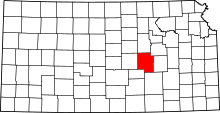 | |
| Unincorporated communities | ||
| Ghost towns | ||
| Townships | ||
| Footnotes | ‡This populated place also has portions in an adjacent county or counties | |