Rajampet
| Rajampet రాజంపేట | |
|---|---|
| Town | |
 Rajampet  Rajampet Location in Andhra Pradesh, India | |
| Coordinates: 14°11′42″N 79°09′29″E / 14.195°N 79.158°ECoordinates: 14°11′42″N 79°09′29″E / 14.195°N 79.158°E | |
| Country | India |
| State | Andhra Pradesh |
| Region | Rayalaseema |
| District | Kadapa |
| Area[1] | |
| • Total | 35.87 km2 (13.85 sq mi) |
| Population (2011)[2] | |
| • Total | 47,220 |
| • Density | 1,300/km2 (3,400/sq mi) |
| Languages | |
| • Official | Telugu |
| Time zone | IST (UTC+5:30) |
| PIN | 516115 |
| Telephone code | +91–8565 |
| Vehicle registration | AP–04 |
| Website | Rajampet Municipality |
Rajampet is a town in Kadapa district of the Indian state of Andhra Pradesh. It is located in Rajampet mandal of Rajampeta revenue division.[3]
Geography
Rajampet has an average elevation of 139 meters.
Governanace
Civic administration
Rajampet was a Gram panchayat before 2005. It was upgraded as Nagar Panchayat on 2 April 2005 and has an extent of 20.60 km2 (7.95 sq mi).[1][4] It consists of 20 election wards.[5]
Politics
Rajampet is a part of Rajampet (Assembly constituency) for Andhra Pradesh Legislative Assembly. Meda Venkata Mallikarjuna Reddy is the present MLA of the constituency from Telugu Desam Party.[6] It is also a part of Rajampet (Lok Sabha constituency) which was won by P. V. Midhun Reddy of YSR Congress Party.[7][8]
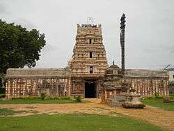
Tourism

Education
There are numerous schools and colleges in Rajampet. In 1998, First engineering college by name Annamacharya Institute of Technology & Sciences was established.[9] Other professional colleges include Narayanadri Engineering College,[10] Modugula Kalavathamma College of Engineering for women.[11]
Transport
Roads are well connected to all major national highways. Rajampet railway station is under South Central Railway of Guntakal railway division.
See also
References
- 1 2 "Municipalities, Municipal Corporations & UDAs" (PDF). Directorate of Town and Country Planning. Government of Andhra Pradesh. Archived from the original (PDF) on 28 January 2016. Retrieved 29 January 2016.
- ↑ "Census 2011". The Registrar General & Census Commissioner, India. Retrieved 25 August 2014.
- ↑ "Revenue Divisions and Mandals". Official website of YSR Kadapa District. National Informatics Centre- Kadapa, Andhra Pradesh. Retrieved 23 May 2015.
- ↑ "Basic Information of Municipality". Commissioner & Director of Municipal Administration. Municipal Administration & Urban Development Department, Govt. of Andhra Pradesh. Retrieved 19 November 2014.
- ↑ "Brief about Municipality". Municipal Administration & Urban Development Department, Government of Andhra Pradesh. Retrieved 7 September 2014.
- ↑ "MLA". AP State Portal. Retrieved 13 October 2014.
- ↑ "MP (Lok Sabha)". Government of AP. Retrieved 4 May 2015.
- ↑ "Delimitation of Parliamentary and Assembly Constituencies Order, 2008" (pdf). Election Commission of India. p. 22,31. Retrieved 11 October 2014.
- ↑ http://www.aitsrajampet.ac.in
- ↑ http://www.nist.ac.in
- ↑ ::..Welcome to Modugala Kalavathamma Institute of Technology for Women..::
External links
| Wikimedia Commons has media related to Rajampet. |
14°11′00″N 79°10′00″E / 14.1833°N 79.1666°E