Radziejów
| Radziejów | |||
|---|---|---|---|
|
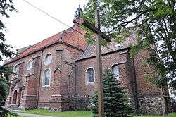
Assumption of Mary Church | |||
| |||
 Radziejów | |||
| Coordinates: 52°38′N 18°31′E / 52.633°N 18.517°E | |||
| Country |
| ||
| Voivodeship | Kuyavian-Pomeranian | ||
| County | Radziejów County | ||
| Gmina | Radziejów (urban gmina) | ||
| Established | 12th century | ||
| Town rights | 1252 | ||
| Government | |||
| • Mayor | Sławomir Bartłomiej Bykowski | ||
| Area | |||
| • Total | 5.69 km2 (2.20 sq mi) | ||
| Elevation | 124 m (407 ft) | ||
| Population (2006) | |||
| • Total | 5,756 | ||
| • Density | 1,000/km2 (2,600/sq mi) | ||
| Time zone | CET (UTC+1) | ||
| • Summer (DST) | CEST (UTC+2) | ||
| Postal code | 88-200 | ||
| Area code(s) | +48 54 | ||
| Car plates | CRA | ||
| Climate | Dfb | ||
| Website | http://www.umradziejow.pl/ | ||


Radziejów [raˈd͡ʑejuf] (German: Rädichau) is a town in Poland, in Kuyavian-Pomeranian Voivodeship, about 45 km south of Toruń. It is the capital of Radziejów County. Its population is 5,804 (2004).
History
The earliest known mention of Radziejów is found in a document from 1142, which states that it was given to the monastery in Mogilno. In the second half of the 13th century it grew into a significant center of local administration. In 1252 its official founding document was issued by the local prince, and in 1292 it obtained its town charter based on Magdeburg Law.
In 1793 the town found itself in Prussia following the Partitions of Poland. In 1807 it passed to the short lived Duchy of Warsaw, and then in 1815 it became a part of the Congress Poland in the Russian Empire. In the course of the 19th century the town declined and in 1871 it lost its city charter. In 1918 it became a part of reconstituted, independent Poland and was again granted city rights in 1919. In 1931 it had 4,025 inhabitants.
The town had a Jewish community since the 18th century, with 15 Jews (5% of the population) recorded in 1793.[1] Restrictions on Jewish settlement were in force from 1822 to 1862.[1] According to the 1921 census the town had a Jewish community consisting of 599 people, or 19.0 percent of its total population.[1]
In 1933 Radziejów obtained a railway connection as the newly built Polish Coal Trunk-Line passed just 3 km west of the town. Though no dedicated Radziejów station was built, the inhabitants of the town could board trains in nearby Chełmce.
During World War II, the German army entered the town on September 9, 1939. During the German occupation, the town was part of Reichsgau Wartheland, a portion of Poland directly annexed by Germany. In 1943 the Germans renamed the town to Rädichau.[2]
In the course of the Holocaust, the town's Jewish population was confined in a ghetto which existed from 1941 until 1942, with about 800 inmates.[1] The ghetto was liquidated in 1942 when its population was transported to Chelmno extermination camp in April, 1942[3][4] where they were killed in gas vans by carbon monoxide exhaust. The town was liberated from the Nazis by the Soviet army on January 20, 1945.
After the war, some Jewish survivors returned to Radziejów in the summer of 1945, where they found their houses and businesses taken over by Poles. After the murder on the night of 29/30 September 1945 of two Jews in nearby village Osięciny, Radziejów's Jews fled the town, but returned a few weeks later. In 1946 they organized a local branch of the Central Committee of Polish Jews (Centralny Komitet Żydów Polskich), which functioned until 1948 by which time most of its members left Radziejów. After 1949 no organised Jewish community existed and only a few individual Jews remained in the town during the subsequent decades.[5]
In 1979 a new hospital opened in Radziejów designed to accommodate 272 patient beds (today functioning as Samodzielny Publiczny Zakład Opieki Zdrowotnej w Radziejowie).
Notes
- 1 2 3 4 Jewish Historical Institute community database
- ↑ Jehke, Rolf. "Amtsbezirk Rädichau Stadt und Land".
- ↑ "Chelmno Deportations". deathcamps.org. Retrieved May 17, 2007.
- ↑ The List of Jewish Communities Liquidated in Chelmno, accessed 2007-05-17
- ↑ "Historia - Społeczność żydowska przed 1989 - Radziejów - Wirtualny Sztetl".
External links
![]() Media related to Radziejów at Wikimedia Commons
Media related to Radziejów at Wikimedia Commons
Coordinates: 52°38′N 18°31′E / 52.633°N 18.517°E
| Seat |
|  |
|---|---|---|
| Urban-rural gmina | ||
| Rural gminas | ||