Radków
| Radków | ||
|---|---|---|
 | ||
| ||
 Radków | ||
| Coordinates: 50°30′14″N 16°24′12″E / 50.50389°N 16.40333°E | ||
| Country |
| |
| Voivodeship | Lower Silesian | |
| County | Kłodzko | |
| Gmina | Radków | |
| Area | ||
| • Total | 15.03 km2 (5.80 sq mi) | |
| Population (2006) | ||
| • Total | 2,460 | |
| • Density | 160/km2 (420/sq mi) | |
| Website | http://www.radkowklodzki.pl/ | |
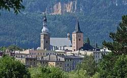
Radków [ˈratkuf] (German: Wünschelburg) is a town in Kłodzko County, Lower Silesian Voivodeship, in south-western Poland. It is the seat of the administrative district (gmina) called Gmina Radków, close to the Czech border. As at 2006, the town has a population of 2,460.[1]
Geography

It lies in the Kłodzko Valley at the foot of the Table Mountains, approximately 20 kilometres (12 mi) north-west of Kłodzko, and 83 kilometres (52 mi) south-west of the regional capital Wrocław.
History
A church at the site was first mentioned in 1290, the settlement itself appeared in a 1328 deed. Located within Bohemian Kłodzko Land, it received town privileges by King Wenceslaus in 1418. In the following decades, the town was devastated by Hussite troops as well as by the Hungarian forces of king Matthias Corvinus.
With the County of Glatz, it turned Protestant by the mid 16th century and was affected by the Counter-Reformation in the Habsburg Monarchy as well as the devastations of the Thirty Years' War. In the First Silesian War 1740-42, the town was conquered by King Frederick II of Prussia. The picturesque setting attracted Johann Wolfgang von Goethe, who spent a few days here in August 1790.
From 1815 onwards, it was incorporated into the Prussian Silesia Province. From the late 19th century onwards, the Wünschelburg sandstone pits supplied notable buildings like the Berlin Reichstag via the new Eulengebirgsbahn railway line to Mittelsteine. After World War II, the area fell to the Republic of Poland according to the 1945 Potsdam Agreement, while the German population was expelled.
Notable people
- Wolfgang Stumph (born 1946), actor.
References
- ↑ "Strona Główna - Gmina Radków". www.radkowklodzki.pl (in Polish). Retrieved 2016-04-19.
| Wikimedia Commons has media related to Radków. |
| Town and seat |  | |
|---|---|---|
| Villages | ||
Coordinates: 50°30′14″N 16°24′12″E / 50.50389°N 16.40333°E