Raddon Top
Coordinates: 50°48′32″N 3°32′56″W / 50.809°N 3.549°W Raddon Top is the highest point of the Raddon Hills, a small ridge of hills in the Shobrooke area of Mid Devon. The summit is at some 235 metres above sea level, making it a significant feature in the surrounding countryside.
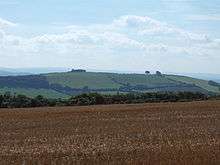
View of Raddon Top from Cadbury Castle
There is an unclassified road that traverses the hill which is the main route from the village of Cheriton Fitzpaine to Exeter.
There were earthworks on the summit, but by the 16th century these had been ploughed away.[1] Archaeological excavations in 1994 revealed remains of an Early Iron Age palisaded enclosure and an Iron Age hillfort with timber ramparts. The same excavations also uncovered a much earlier Neolithic causewayed enclosure.[2]
References
This article is issued from Wikipedia - version of the 9/27/2014. The text is available under the Creative Commons Attribution/Share Alike but additional terms may apply for the media files.