Racks railway station
| Racks | |
|---|---|
|
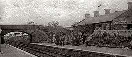
Racks station in 1900 | |
| Location | |
| Place | Dumfries |
| Area | Dumfries and Galloway |
| Operations | |
| Original company | Glasgow, Dumfries and Carlisle Railway |
| Pre-grouping | Glasgow and South Western Railway |
| Post-grouping | LMS |
| Platforms | 2 |
| History | |
| 23 August 1848[1] | Opened |
| 6 December 1965[1] | Closed |
| 6 May 1964 | Closed to goods traffic |
| Disused railway stations in the United Kingdom | |
|
Closed railway stations in Britain A B C D–F G H–J K–L M–O P–R S T–V W–Z | |
|
| |
Racks railway station was a railway station in Dumfries and Galloway, Scotland, south of Dumfries, OS NGR NY 033 743, serving and effectively creating[2] the village of Racks near the Lochar Water, 4 miles ESE of Dumfries; a rural community within the Parish of Torthorwald. [3][4]
History
The station, 62.64 miles south of Glasgow Saint Enoch station, opened in July 1848.[5] The station is now closed, although the line running through the station remains open. The station building has been converted into a private dwelling. The difference in height between the main building and platform level was overcome by the use of two fenced diagonal ramps built into the slope with the remainder of the area occupied by a profusion of shrubbery and flower beds.
Racks was opened by the Glasgow, Dumfries and Carlisle Railway, which then became part of the Glasgow and South Western Railway; in 1923 it became part of the London Midland and Scottish Railway at the Grouping, passing on to the Scottish Region of British Railways following the 1948 nationalisation of the railways. It was closed by the British Railways Board.
Services
| Preceding station | Historical railways | Following station | ||
|---|---|---|---|---|
| Dumfries Line open; station open |
Glasgow and South Western Railway Glasgow, Dumfries and Carlisle Railway |
Ruthwell Line open; station closed | ||
Views of Racks in 2010
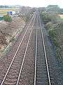 The site of the old station
 The old station buildings
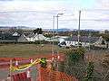 Racks village from the railway overbridge
References
- 1 2 Butt, p. 193.
- ↑ History of Torthorwald Church. Accessed : 2010-07-11
- ↑ "Racks railway station". Retrieved 2009-10-25.
- ↑ "Ordnance Gazetteer for Scotland". Retrieved 2009-10-25.
- ↑ Lindsay, David M. E. (2002). G&SWR Register of stations, routes & lines. G&SWR Association. Part 6.3, Page 20
Sources
- Butt, R. V. J. (1995). The Directory of Railway Stations: details every public and private passenger station, halt, platform and stopping place, past and present (1st ed.). Sparkford: Patrick Stephens Ltd. ISBN 1-8526-0508-1. OCLC 60251199.
External links
Coordinates: 55°03′14″N 3°30′53″W / 55.0540°N 03.5148°W