R597 road (Ireland)
| ||||
|---|---|---|---|---|
|
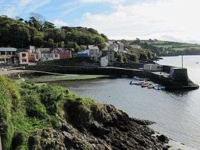
R597 above harbour at Glandore, Co. Cork | ||||
| Route information | ||||
| Length: | 10.2 km[1][2] (6.3 mi) | |||
| Major junctions | ||||
| From: |
| |||
| To: |
| |||
| Road network | ||||
| ||||

The R597 road is a regional road in Ireland. It is a loop road from the N71 on the Haven Coast in west County Cork.[1][2][3] The road forms part of the Wild Atlantic Way.[3]
The R597 travels south from the N71 at Leap to the port village of Glandore.[1] After Glandore, the road travels east and passes the megalithic Drombeg stone circle.[3] It rejoins the N71 at the town of Rosscarbery. The R597 is 10.2 km (6.3 mi) long.[1]
References
- 1 2 3 4 Google (9 Jun 2016). "N71 to R597" (Map). Google Maps. Google. Retrieved 9 Jun 2016.
- 1 2 "S.I. No. 54/2012 – Roads Act 1993 (Classification of Regional Roads) Order 2012". Government of Ireland. 28 Feb 2012. Retrieved 9 Jun 2016.
- 1 2 3 "Wild Atlantic Way: Haven Coast Driving Route". Fáilte Ireland. Retrieved 9 Jun 2016.
This article is issued from Wikipedia - version of the 6/11/2016. The text is available under the Creative Commons Attribution/Share Alike but additional terms may apply for the media files.