Ileanda
| Ileanda | |
|---|---|
| Commune | |
|
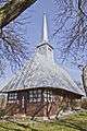
Wooden Church in Ileanda | |
 Ileanda in Sălaj County | |
 Ileanda Ileanda within Romania | |
| Coordinates: 47°19′39″N 23°36′58″E / 47.32750°N 23.61611°E | |
| Country |
|
| County |
|
| Commune | Ileanda |
| Historic region | Transylvania |
| Government | |
| • Mayor | Cornel Satmari (National Liberal Party) |
| Area | 87.59 km2 (33.82 sq mi) |
| Population (2002)[1] | 2,589 |
| Time zone | EET (UTC+2) |
| • Summer (DST) | EEST (UTC+3) |
| Website | www.ileanda.ro |

Ileanda (Hungarian: Nagyilonda) is a commune located in Sălaj County, Romania. It is composed of thirteen villages: Bizuşa-Băi (Büdöspataka), Bârsăuţa (Kisborszó), Dăbiceni (Kisdoboka), Dolheni (Ilondapatak), Ileanda, Luminişu (Szakadás), Măleni (Kisilonda), Negreni (Konkolyfalva), Perii Vadului (Révkörtvélyes), Podişu (Csömény), Răstoci (Hosszúrév), Rogna (Kornislaka) and Şasa (Sasfalu).
History
Human settlement began in Dacian times.[2]
In the 1830s, Jews began to arrive in Ileanda, and by the end of the century, the community ran nearly all commerce and small industry in the village and its surroundings. In the interwar period, there was a yeshiva with 30 to 40 students, while Zionist activity started in the 1920s. In 1930, there were 308 Jews or 26% of the population. In June 1942, 11 Jews were drafted into labor battalions in Reichskommissariat Ukraine, of whom two survived.[3] In May 1944, 900 Jews were sent by the authorities of the Kingdom of Hungary to the Dej ghetto and then to the Auschwitz concentration camp. József Paneth, who became the local rabbi in 1926, escaped deportation to Romania with his family.[3][4] Following World War II, he served the surviving Jews until the community dispersed in 1950.[3]
Sights
- Wooden Church in Ileanda, built in the 17th century, historic monument
- Wooden Church in Negreni, built in the 17th century, historic monument[5]
- Wooden Church in Răstoci, built in the 19th century (1828), historic monument[6]
- Wooden Church in Podişu, built in the 18th century, historic monument
- Forest “La Castani”, Natural reserve
- Măgurici Cave, Natural reserve
References
- ↑ Romanian census data, 2002; retrieved on March 1, 2010
- ↑ (Romanian) "Short history" at the Ileanda Town Hall site; accessed October 25, 2013
- 1 2 3 Shmuel Spector, Geoffrey Wigoder (eds.), "Ileanda" in The Encyclopedia of Jewish Life Before and During the Holocaust: A-J, p.544-545. NYU Press, 2001, ISBN 0814793762
- ↑ (Romanian) "Ghettoes" at the Northern Transylvania Holocaust Memorial Museum site; accessed October 25, 2013
- ↑ welcometoromania.ro - Wooden Church in Negreni, Sălaj County, retrieved on May 17, 2012
- ↑ welcometoromania - Wooden Church in Răstoci, Sălaj County, retrieved on May 17, 2012
External links
Image gallery
 Wooden Church in Negreni
 Wooden Church in Răstoci
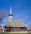 Wooden Church in Podişu
Coordinates: 47°20′N 23°38′E / 47.333°N 23.633°E