Römerstein
| Römerstein | ||
|---|---|---|
 | ||
| ||
 Römerstein | ||
Location of Römerstein within Reutlingen district 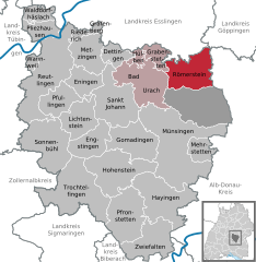
 | ||
| Coordinates: 48°29′44″N 09°30′38″E / 48.49556°N 9.51056°ECoordinates: 48°29′44″N 09°30′38″E / 48.49556°N 9.51056°E | ||
| Country | Germany | |
| State | Baden-Württemberg | |
| Admin. region | Tübingen | |
| District | Reutlingen | |
| Government | ||
| • Mayor | Matthias Winter | |
| Area | ||
| • Total | 46.05 km2 (17.78 sq mi) | |
| Population (2015-12-31)[1] | ||
| • Total | 3,984 | |
| • Density | 87/km2 (220/sq mi) | |
| Time zone | CET/CEST (UTC+1/+2) | |
| Postal codes | 72587 | |
| Dialling codes | 07382 | |
| Vehicle registration | RT | |
| Website | www.roemerstein.de | |

Römerstein is a municipality in Baden-Württemberg, Germany; three formerly independent villages (Böhringen, Donnstetten, Zainingen) and two hamlets (Strohweiler and Aglishardt) were merged in 1975. Townhall is in Böhringen.
The community is located on the Swabian Alb, in the northeastern corner of the district of Reutlingen. The community is named after the Römerstein, the highest hill of the region at 875 m.
Geographical location
The municipality is located about 22 kilometers east of Reutlingen on the plateau of the Swabian Alb at an altitude of 803 m above sea level. NN (Rathaus Donnstetten). It is to the highest elevation of the municipality, the Römerstein (874 m above sea level. NN), named.
Neighboring communities
The following cities and towns bordering the municipality Römerstein, they are starting called clockwise to the north: Lenningen (Esslingen district) Wiesensteig (Göppingen District), Westerheim, Laichingen (both Alb-Donau-Kreis), Gutsbezirk Münsingen, Bad Urach and grave Stetten (all district Reutlingen).
Municipality arrangement
The community consists of the previously independent municipalities Böhringen, Donnstetten and Zainingen. The former municipalities Donnstetten and Zainingen today form localities within the meaning of Baden-Württemberg municipal code with ensuite Ortschaftsrat and mayor . For location Böhringen include the village Böhringen, the Weiler Weiler straw and the homestead Aglishardt. For location Donnstetten include the village and the house Donnstetten Roman stone houses, a 1912 erected observation tower at the Römerstein. For location Zainingen heard only the village of the same name. In the municipality Römerstein are several proofs of former, no more existing today places; in the territory of the village Böhringen the 1487 as a fish Husen and probably risen in Aglishardt Fischhausen that in 1454 as mentioned at the Gaiswyler Geisweiler, Gölenbrunnen, Hofen, both in 1275 places mentioned Ichenhusen and Horgen hole, said around 1192 as Cazcensteige place Katzensteig, the 1454 as to Oberwiler mentioned Oberweiler, the 1345 mentioned as uf Vohenhusen Vohenhausen and the 1204 Zimberbuch and 1299 mentioned as Zymberbuch room book, in the territory of the village Donnstetten are the two deserted villages Beuren, on a field name indicates, and Red Court. [2]
History
Presumably the settlement was in the Roman settlement back Clarenna. The identification of the Roman town Clarenna which is passed down through the Peutingertafel is, with the archaeological finds in Donnstetten very likely, but not absolutely certain. → Main article: Castle Donnstetten The municipality Römerstein originated during the Baden-Württemberg district reform on 1 January 1975 as a merger of the formerly independent municipalities Böhringen (with thatched hamlets and Aglishardt) Donnstetten and Zainingen. The entire current community area was formerly part of the district of Münsingen and came with its resolution 1973 the district of Reutlingen . Coat of Böhringen
Böhringen
Böhringen was 1090 documentary mentioned for the first time together with the Hofgut Aglishardt. The place was originally part of Kirchheimer hundred . About the Men of Sperbereck Böhringen came in the 15th century to Württemberg . In the Thirty Years' War the city was almost completely destroyed. In World War II there was in the last days of the war heavy destruction. Coat of Donnstetten
Donnstetten
Already 776 Donnstetten was in a document of Lorsch called Tunnesstate. 1603 it became part of Württemberg . Coat of Zainingen
Zainingen
Zainingen was first 788 as Zeininger marca in Lorsch codex mentioned. 1383 was the place to Württemberg .
Religions
The St. George's Church in Donnstetten district Already in 1192 the St. Gallus Church in Böhringen mentioned. The church was first mentioned in Zainingen 1275th Donnstetten which previously belonged ecclesiastically to Zainingen, since 1447 has the status of a separate parish. Since the introduction of the Reformation, the places are Lutheran coined. In Römerstein Today there are three Protestant churches, the Protestant parish Böhringen with St. Gallus Church, the Protestant parish Zainingen with Martin Church and the Protestant church Donnstetten-Westerheim with the St. George's Church. The members of the United Methodist Church gather in Laichingen, while the Catholics of the parish of St. Joseph are assigned in Bad Urach.
Politics
The administrative center is Böhringen, local administrative bodies are in Donnstetten and Zainingen.
Council
The council Römerstein has 14 members. The local elections on 25 May 2014 led to the following official results. The turnout was 64.4% (2009: 65.8%). The council consists of the elected honorary councilors and the mayor as chairman. The mayor is entitled to vote in the municipal council.
- Free Bürgerliste Römerstein 45.3% 6 seats (2009: 55.7%, 8 seats)
- Independent Citizens List Römerstein 54.7% 8 seats (2009: 44.3%, 6 seats)
Mayor
The mayor is elected for a term of eight years.
- 1975-1999: Hans Sigel
- 1999-2013: Michael Donth
- 0000: Matthias Winter
Crest
Blazon : "About a double row of black and silver geschachten sign foot in Blue a flying upwards golden hawk."
Things
St. Gallus Church in Böhringen
The Martin church offered shelter for the villagers and traveling merchants
The mansion in Hofgut Aglishardt
Roman stone tower Römerstein is located on the Swabian Alb Route, which passes by many sights.
Museums
In Donnstetten is a local history museum in the parish barn.
Teams
- German Red Cross, the local association Römerstein: Founded in 1976 as a result of local government reform from the three DRC -Ortsgruppen Böhringen, Donnstetten and Zainingen.
- Swabian Albverein eV, local group Zainingen: Founded in 1949 in Zainingen
Music
- Accordion and Concertina Club Römerstein e. V., founded in 1951 in *Donnstetten
- Vocal Group "Frohsinn" Böhringen Founded in 1887
- Liederkranz Donnstetten founded 1843
- Musikverein Zainingen e. V. founded in 1920
- Musikverein "harmony" Donnstetten, founded in 1895 as a mouth Erich's Chapel
Sports
- Sportfreunde Donnstetten founded, April 3, 1948
- Sportverein Zainingen, founded March 14, 1926
- TSV Böhringen founded in 1919
- FC Römerstein founded 2005
Buildings
- The St. Gallus Church in Böhringen was built in neo-Gothic style in the years 1885-86, the choir dates from 1498th
- The Church of St. George in Donnstetten was built in the 15th century.
The Year of St Martin's in Zainingen is not precisely known. On the wall behind the organ, the date can be seen 1494th Noteworthy is the originating from the 1559 mighty churchyard wall. This served both the Zainingern, as well as the time traveling through the village merchants as protection against any risk. Zainingen was on the former trade route Paris-Prague. There is a fresco on the south wall Christopher, the patron saint of travelers, from the 15th century.
Towers
- The 28 m high Römersteinturm is located on the 872 m high Römerstein three kilometers north and was emerged 1912.

- The 20 m high Waldgreutturm is two kilometers southeast of Zainingen. [3]
- The 42 m high tower is Hursch southwest of Zainingen. [4]
Transportation
Römerstein is conveniently located on the main roads 28 and 465 ( Kirchheim unter Teck - Leutkirch im Allgäu ), which pass through the municipality. Public transport is by the Verkehrsverbund Neckar-Alb-Donau guaranteed (NALDO). The community is located in the comb 222nd
Tourism
Winter sports in Römerstein Three ski lifts and six inter-related cross-country trails totaling over 50 kilometers in length make Römerstein a popular winter sports resort in the Swabian Alb. Römerstein has a bobsled, and Zainingen one reaches the Swabian Alb Biosphere Reserve in the former military training area Münsingen . In the center of Zainingen be one of the last original is obtained Hülen in the Swabian Alb. From the covered observation deck of the Roman stone tower a view in all four directions over medium Alb is possible.
Education
The main school Römerstein in Böhringen and primary schools in Zainingen and Donnstetten there in Römerstein three schools. For the youngest inhabitants there is a municipal and two Protestant kindergartens.
Sons and daughters of the town
- (Ludwig) Friedrich Gifftheil, as a minister's son in 1595 was born in Böhringen, died in 1661 in Amsterdam ; pacifist and religious writer, one of the pioneers of early Pietism in the Netherlands, friend of Hermann Jung and Friedrich Breckling . [5]
- Georg Length (1898-1990), called "Knight Bauer", original head of the pietistic community hour in Böhringen (Swabian Alb), which was under the influence of Münsinger teacher Friedrich Mayer, the Altpietismus and of the lay preacher Johann Michael Hahn unites justified theosophical pietism Has. Georg Länges importance was pietism researcher Reinhard Breymayer appreciated sinc
Towns and municipalities in Reutlingen (district) | ||
|---|---|---|
| Wikimedia Commons has media related to Römerstein. |