Questa, New Mexico
| The Village of Questa | |
|---|---|
| Village | |
|
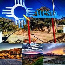
Questa, NM and scenic views
 Questa 1943 | |
| Motto: Gateway to the Rio Grande del Norte National Monument | |
 Location of Questa, New Mexico | |
 The Village of Questa Location in the United States | |
| Coordinates: 36°42′23″N 105°35′35″W / 36.70639°N 105.59306°WCoordinates: 36°42′23″N 105°35′35″W / 36.70639°N 105.59306°W | |
| Country | United States |
| State | New Mexico |
| County | Taos |
| Government | |
| • Type | Municipal |
| • Mayor | Mark Gallegos |
| Area | |
| • Total | 5.1 sq mi (13.2 km2) |
| • Land | 5.1 sq mi (13.2 km2) |
| • Water | 0.0 sq mi (0.0 km2) |
| Elevation | 7,461 ft (2,274 m) |
| Population (2000) | |
| • Total | 1,767 |
| • Density | 365.0/sq mi (140.9/km2) |
| Time zone | Mountain (MST) (UTC-7) |
| • Summer (DST) | MDT (UTC-6) |
| ZIP code | 87556 |
| Area code(s) | 575 |
| FIPS code | 35-60870 |
| GNIS feature ID | 0909932 |
| Website | http://questa-nm.com/ |
Questa is a village in Taos County, New Mexico, United States. The population was 1,767 at the 2000 census. Questa is renowned for the beautiful scenery surrounding the small, historic village. The Village offers rare trails into the Rio Grande Gorge, trout fishing for every skill level, and mountain lakes with trails that access the highest reaches of the Sangre de Cristo Mountains overlooking the area. In addition to famously serene camping and stunning hikes, there are many choices for cycling, mountain biking and horseback excursions. Located on the Enchanted Circle Scenic Byway, near the confluence of the Rio Grande and the Red River, Questa offers scenic and serene activities in the protected natural environment surrounding the Village. As the Gateway to the Rio Grande del Norte Monument visitors can enjoy a scenic drive to a stunning overlook of the Red River meeting the Rio Grande in the depth of the Gorge. The Carson National Forest parallels Questa to the east offering high mountain hiking, picnicking, camping and biking. The Columbine Hondo Wilderness and Latir Peak Wildness are found in the Carson National Forest close to Questa. The Red River is undergoing restoration to improve trout habitat with currently a section parallel to Eagle Rock Lake complete.
The Historic San Antonio del Rio Colorado Church in the historic plaza of Questa symbolizing the cultural heart of Questa since the mid-1800s. After suffering a collapse of the west wall in Questa’s historic church the community came together and many of the families that built the church originally are restoring it modern day. Made with beautiful adobe and wood work it is scheduled to be completed mid-2016. The Historic church is open free to the public and anyone of any faith or not of a faith is welcome to come see the jewel of Questa.
With a large Hispanic population, the village economy was historically largely dependent on agriculture and income from a now-closed Chevron molybdenum mine. Many residents also commute to Taos, Red River, and Angel Fire to work in the hospitality industries there.
Geography
Questa is located at 36°42′23″N 105°35′35″W / 36.70639°N 105.59306°W (36.706302, -105.593058).[1]
According to the United States Census Bureau, the village has a total area of 5.1 square miles (13.2 km²), all land. The village is a regional hub for the smaller outlying communities of Lama, Cerro, Sunshine Valley, Latir, Costilla, and Amalia. Questa is surrounded by the Rio Grande del Norte National Monument to the west and the Carson National Forest to the East.
Questa lies at the western base of the Taos Mountains, part of the Sangre de Cristo Mountains. Rising above the town to the northeast is the Latir Peak massif, headed by Venado Peak, 12,734 ft (3,881 m); Pinabete Peak, a southwestern outlier of the group, rises closest to Questa. To the southeast lies Flag Mountain, a northwestern spur of the group of mountains that includes Wheeler Peak, the highest peak in New Mexico. To the north and west lie the Rio Grande Gorge, cutting a volcanic plateau dotted with several peaks of volcanic origin in the Rio Grande del Norte National Monument.

History
Questa was originally named San Antonio del Rio Colorado. Later, a U.S. postmaster changed its name to Questa.[2] The postmaster misspelled the name — according to Spanish spelling rules, it should have been spelled Cuesta, which was derived from the Spanish for "ridge" or "slope." Despite the error, the village has kept the name.
The village of Questa is located close to the ancient Kiowa trail, a Native American trade route which connected the Ute, Kiowa, and Comanche tribes to the north with the Pueblo tribes to the south. Evidence of this route can be seen in trail remnants, artifacts, and petroglyphs along the western slopes of the Sangre de Cristo Mountains (Rael and Cuddihy, 2003). The first Hispanic visitor to the area may have been Francisco Vásquez de Coronado; certainly the area was known to the Spanish by 1593, when the gold-seekers Juan Humana and Francisco Borilla were killed by tribes along the Purgatoire River.
Mining activity in the area, including the apocryphal Governor's mine (NM Bureau of Geology and Mineral Resources, RM-21), probably began around that time, and continued until the Pueblo Revolt of 1680. The use of forced labor in gold mining is often cited as the cause of the revolt, but records of that time are incomplete, and the locations of these mines are lost. Candidates for "Lost Spanish Gold Mines" are frequently proposed in the Sangre de Cristo, San Juan, and Ortiz Mountains; few have been verified.
After the Pueblo Revolt, Spanish occupation was slow to return to the Questa area due to repeated clashes with Taos and Ute warriors; although reports of trading and military activity in the area, especially by French, French-Canadian, and even English fur traders, the actual date of establishment of a permanent settlement in the area is recorded as 1820 (Rael and Cuddihy, 2003).
Even then, the threat of Indian raids was considerable. The location of the incipient village at the confluence of the rivers, and astride the ancient trade, raiding, and hunting routes, made resource-based conflict between cultures inevitable. Additionally, the village location blocked access to certain historic clay and pigment quarries of great ceremonial importance to the Taos tribe. This continued conflict lead to the village being repeatedly abandoned. Spanish, Mexican, and eventually American soldiers detailed to defend the beleaguered settlement frequently expressed great frustration with their posting (Rael and Cuddihy, 2003).

The names of two prominent peaks overlooking the village of Questa, Flag Mountain and Sentinel Peak, refer to the practice, during this period, of stationing watchmen on these high points to warn the village of approaching war parties.
The village, nearly from the beginning, was of mixed blood; the surnames Lafore or Laforet, Ledoux, and LaCome reflect the names of French or French-Canadian trappers who settled in the area after arriving in search of otter and beaver. New Mexico territory license records list Auguste Lacome as residing in the area as a trader with the surrounding Native Americans. The common surname Rael may also reflect the influence of Jewish immigrants arriving after being expelled from Spain. The village had a reputation for being contentious and requiring disproportionate effort to police; records show that viceregal intervention was frequently required to settle property disputes (Rael and Cuddihy, 2003).
Arts and Culture
Visitor Attractions

The Historic San Antonio del Rio Colorado Church is found in the historic plaza of Questa. The San Antonio del Rio Colorado Church services as a cultural heart to Questa, present since the mid-1800s. After suffering a collapse of the west wall in Questa’s historic church the community came together and many of the families that built the church originally are restoring it modern day. Made with beautiful adobe and wood work it is scheduled to be completed mid-2016. The Historic church is open free to the public of any faith or not of faith to come see the jewel of Questa.
Surrounding Questa are the Rio Grande del Norte National Monument and the Carson National Forest offering hiking, fishing, camping, and picnicking. Right beside Questa's Village limits is the Eagle Rock Lake a scenic walking and fishing location around a lake bordered by the Red River, and right up against mountains. The Red River is currently undergoing restoration to improve trout habitat with the section parallel to Eagle Rock Lake complete. Questa has OCHO an Art Galley and Event Space featuring shows and events throughout the year, local art shops, and a prolific thrift shop. Several eateries are located in and around the village. Wildcats Den is a local favorite for decades famous for their green Chili Cheeseburger. Tia's Cafe, a Mexican cafe, is located on route to the Rio Grande del Norte National Monument. Bo's Place is a family style restaurant with Lainey’s Licks an ice-cream palor in the front on the building.The
Event Series
Questa has a themed summer Event Series which celebrates art, youth, and the environment is special sub-themed events. Individual events separate of the summer Event Series are the Mud Bogg, the Questa Fiesta, and Alumbra de Questa.
Parks and Recreation
Questa has two local parks: the Municipal Park and the Moly Park. The Municipal Park is relatively new and is a product of the hard work done by local students. Right by the Questa Library the park and playground it is open to all age ranges. The Moly Park contains public athletic fields.

Outside and extremely near Questa is the surrounding Rio Gande del Norte National Monument and Carson National Forest. Within the National Forest is Eagle Rock Lake right next to Village limits featuring a walking loop, fishing, and picnicking. The Cabresto Lake features hiking trails, swimming, fishing, canoeing, picnicking, and camping. The trails from Cabresto Lake lead to mountain top lakes in the Latir Peaks Wilderness. In the Rio Grande del Norte National Monument hiking trails, fishing, picnicking, and camping are found. On the Monument two popular locations: the La Junta Overlook where the Rio Grande and the Red River come together over 800 feet below and the Big Arsenic Trail containing Petroglyphs and a natural spring.
Demographics
| Historical population | |||
|---|---|---|---|
| Census | Pop. | %± | |
| 1970 | 1,095 | — | |
| 1980 | 1,202 | 9.8% | |
| 1990 | 1,707 | 42.0% | |
| 2000 | 1,864 | 9.2% | |
| 2010 | 1,770 | −5.0% | |
| Est. 2015 | 1,753 | [3] | −1.0% |
As of the census[5] of 2000, there were 1,767 people, 741 households, and 512 families residing in the village. The population density was 365.0 people per square mile (140.8/km²). There were 888 housing units at an average density of 173.9 per square mile (67.1/km²). The racial makeup of the village was 50.16% White, 0.11% African American, 0.70% Native American, 0.05% Asian, 0.11% Pacific Islander, 43.40% from other races, and 5.47% from two or more races. Hispanic or Latino of any race were 80.53% of the population.
There were 741 households out of which 35.6% had children under the age of 18 living with them, 49.3% were married couples living together, 13.8% had a female householder with no husband present, and 30.8% were non-families. 26.5% of all households were made up of individuals and 9.9% had someone living alone who was 65 years of age or older. The average household size was 2.52 and the average family size was 3.02.
In the village the population was spread out with 28.0% under the age of 18, 7.4% from 18 to 24, 26.3% from 25 to 44, 25.4% from 45 to 64, and 12.9% who were 65 years of age or older. The median age was 38 years. For every 100 females there were 95.4 males. For every 100 females age 18 and over, there were 95.3 males.
The median income for a household in the village was $23,448, and the median income for a family was $30,000. Males had a median income of $26,667 versus $20,000 for females. The per capita income for the village was $13,303. About 20.7% of families and 24.3% of the population were below the poverty line, including 29.8% of those under age 18 and 20.4% of those age 65 or over.
Economy
The Chevron Questa molybdenum mine was the largest private employer in Taos County.[6] Located nine miles from Questa, the mine opened in 1916 as the R&S Molybdenum mine. It was purchased by Molycorp Minerals in 1950 and became a subsidiary of Chevron in 2005.[7] Formerly an open pit excavation, the Chevron Questa mine operated as an underground mine from 1982.[8][9] Economic conditions that affect the mine resulted in a 54 percent cut in personnel in February 2009, which primarily impacted the residents of Questa.[6] On June 2, 2014, Chevron Mining announced the immediate and permanent closure of the mine due to continuing low molybdenum prices and high operating costs.[10][11] The mine was employing about 300 people at the time of the shutdown. Currently, the mine is either directly or thru its contractors is employing about 150 people on work related to reclamation and remediation.
.jpg)
Agriculture, especially the cultivation of alfalfa, hay, and winter wheat has experienced renewed interest along with the expansion of agriculture to historic crops and crops of high value. Agriculture in Questa is strongly dependent on irrigation, supplied from the Red River and Cabresto Creek. The system of ditches or acequias which supply water to the fields are of great community and social importance; the burning of the ditches on the first weekend after the vernal equinox is a major community event. Two major 'ditch associations' control the distribution of water by controlling the outflow from the Cabresto Lake dam: the Acequia Madre and the Llano ditch.
Historically, sheep were raised in and around Questa, but they have been replaced by cattle. Cattle are grazed on the plains north and west of town during the winter and spring, then moved west to the other side of the Rio Grande in early June, usually driven across the "Sheep Crossing" ford by riders on horseback.
Increasingly, the traditional economy based on agriculture, livestock, handicrafts (particularly wooden religious carvings known as santos), wood gathering, and honey is failing to meet the financial needs of the populace of Questa. Some locals blame the rising cost on the influx of celebrities and affluent Anglos to the Taos area driving up land and home prices, but for whatever cause an increasing number of Questenos commute to work in Red River, Taos and Angel Fire.
Questa has developed as a Tourist destination. With the Historic San Antonio del Rio Colorado Church, Rio Grande del Norte National Monument, Eagle Rock Lake, and the Carson National Forest several avenues for tourism based economic opportunities have taken shape and continue to grow based on the previous and to be expanded tourist activities.
Education
Questa has two public school systems Alta Vista Elementary & Intermediate School and Questa Junior & Senior High School. Both schools belong to the Questa Independent School System servicing Questa and the surrounding communities. Near Questa in Lama Roots and Wings Community school an Expeditionary Learning School is located.
Government
Questa is a Municipal government officially founded in 1842.The Village of Questa is governed by a Mayor, currently Mark Gallegos, and a four-member Village Council, who have 4-year staggered terms. Questa Village offices are located at: 2500 Old State Rd. 3 (off main road, north of the light, behind the Police Station) Questa, NM 87556. Village Council meetings are open and scheduled monthly; on 3rd Tuesdays, at 6pm.
The Motor Vehicle Division located near the Village Offices provides Driver’s Licenses, motor vehicle registrations and title transfers for the residents of Questa and our surrounding communities.
The Questa Fire Department, the Village of Questa Police Department and EMS provides 24-hour service 7 days a week.
Infrastructure and Transportation
Major Highways
Questa's village center has the two major New Mexico State Highways 522 and 38 connecting. State Highway 522 heads south to Taos and north to the Colorado border. State Highway 38 connects Questa to Red River and Eagle Nest as part of the scenic Enchanted Circle.
Alternative Transportation
The Village of Questa is serviced by the Blue Bus, a bus service providing free service to Red River and Taos during commute hours. For air travel the Questa Municipal Airport Nr 2, owned by the Village of Questa, is available.

Questa contains several opportunities to foot transportation. On the west side of the village Eagle Rock Lack offers a scenic walking path around the lake and a parallel trail through the ponderous and beside the Red River. Eagle Rock is parallel to the Red River and is right at the foot of the mountains. To the north of Questa is the Las Vistas de Questa Trail in the Rio Grande del Norte National Monument. A moderate hike with dramatic views of the Sangre de Cristo Mountains and Questa.
Utilities
The Water/Sewer Department of the Village of Questa operates water and sewer for the Questa Area. Kit Carson Electric Cooperative, Inc. supplies electricity and is in the process of implement the Fiber Optic Project. Kit Carson Electric Cooperative, Inc is currently laying fiber optic lines in Taos County.
Healthcare
PMS Questa Health Clinic provides medical, dental, and behavioral health care for Questa and the surrounding area. EMS services run 24/7, servicing Questa and the Surround area. The Holy Cross Hospital is the nearest hospital to Questa at roughly 30 miles from the heart of the Village.
For Alternative Health Resources Sage Acutonics and Massage, and Iris Herbal are local businesses offering their services.
See also
- Rio Grande del Norte National Monument
- Wild Rivers Recreation Area
- Carson National Forest
- Auguste Lacome
References
- ↑ "US Gazetteer files: 2010, 2000, and 1990". United States Census Bureau. 2011-02-12. Retrieved 2011-04-23.
- ↑ Questa Home Page
- ↑ "Annual Estimates of the Resident Population for Incorporated Places: April 1, 2010 to July 1, 2015". Retrieved July 2, 2016.
- ↑ "Census of Population and Housing". Census.gov. Archived from the original on May 11, 2015. Retrieved June 4, 2015.
- ↑ "American FactFinder". United States Census Bureau. Archived from the original on September 11, 2013. Retrieved 2008-01-31.
- 1 2 Andy Dennison, "Updated story: Massive layoffs at Questa mine", The Taos News, 21 February 2009
- ↑ "History" Archived September 7, 2009, at the Wayback Machine., Molycorp Minerals, retrieved 08-10-2009
- ↑ Andy Dennison, "Open-pit mining proposed at Questa mine", The Taos News, 2 August 2008
- ↑ Schilling, John, 1990. A history of the Questa molybdenum (moly) mines, Taos County, New Mexico. New Mexico Geological Society Guidebook, 41st Annual Field Conference, Southern Sangre de Cristo Mountains, New Mexico, p. 381-386.
- ↑ Logan, J.R. (June 2, 2014). "Questa mine permanently closed, 300 laid off". The Taos News. Retrieved September 9, 2014.
- ↑ Logan, J.R. (September 7, 2014). "Turnaround of post-mining Grants could offer hope to Questa". The Taos News. Retrieved September 9, 2014.
External links
- The Taos News - The newspaper of record for Taos County
- Chevron Mining
- Questa profile at City Data
- Questa profile at Carson National Forest
Municipalities and communities of Taos County, New Mexico, United States | ||
|---|---|---|
| Towns | 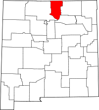 | |
| Villages | ||
| CDPs | ||
| Other unincorporated communities | ||
| Indian reservation | ||