Queensborough Bridge
For the bridge in New York City, see Queensboro Bridge.
| Queensborough Bridge | |
|---|---|
|
The Queensborough Bridge seen from the south side | |
| Coordinates | 49°11′47″N 122°56′50″W / 49.196415°N 122.947183°WCoordinates: 49°11′47″N 122°56′50″W / 49.196415°N 122.947183°W |
| Carries | Four lanes of British Columbia Highway 91A, pedestrians and bicycles |
| Crosses | North Arm Fraser River |
| Locale | New Westminster |
| Maintained by | British Columbia Ministry of Transportation |
| Characteristics | |
| Total length | 924 m |
| History | |
| Opened | 1960 |
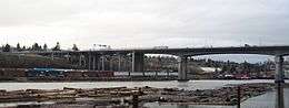
Queensborough Bridge is a highway bridge in New Westminster, British Columbia. It was built in 1960 by the City of New Westminster, costing $4 million. The bridge spans the north arm of the Fraser River for road access from the main part of New Westminster to the suburb of Queensborough at the east end of Lulu Island, giving the bridge its name.
It has since become a part of Highway 91A feeder to Highway 91 to the south. Queensborough was a toll bridge until bought by the provincial government in November 1966. In 2008, the northern exit has been upgraded into a better intersection with Marine Way and Stewardson Way.
See also
| Wikimedia Commons has media related to Queensborough Bridge. |
References
This article is issued from Wikipedia - version of the 10/9/2016. The text is available under the Creative Commons Attribution/Share Alike but additional terms may apply for the media files.