Qaral
| Qaral | |
|---|---|
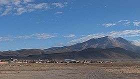 Qaral as seen from the village of San Juan | |
| Highest point | |
| Elevation | 4,988 m (16,365 ft) [1] |
| Coordinates | 20°49′07″S 67°46′53″W / 20.81861°S 67.78139°WCoordinates: 20°49′07″S 67°46′53″W / 20.81861°S 67.78139°W |
| Geography | |
 Qaral Location in Bolivia | |
| Location |
Bolivia, Potosí Department |
| Parent range | Andes |
Qaral[2] (Hispanicized spelling Caral, also spelled Karal, Kjaral, K'aral) is a 4,988-metre (16,365 ft) high mountain in the Bolivian Andes. It is situated in the Potosí Department, Nor Lípez Province, Colcha "K" Municipality. Qaral lies south of the Uyuni salt flat, south-west of the mountain Lliphi. Some of the nearest villages are Santiago and San Juan (San Juan del Rosario). An intermittent stream named Urqu Sunqu (Quechua for mountain heart, Orkho Sonkho) originates at the mountain. It flows to the south-west.[1][3]
References
- 1 2 Bolivian IGM map 1:50,000 Estancia Chilala 6031-IV
- ↑ Francisco M. Gil García, A la sombra de los mallkus. Tradición oral, ritualidad y ordenamiento del paisaje en una comunidad de Nor Lípez (Potosí, Bolivia), Revista Española de Antropología Americana 2008, vol. 38, núm. 1, 217-238 (in Spanish)
- ↑ "COLCHA "K"". INE, Bolivia. Retrieved October 9, 2014.
Capital: Potosí | ||
| Provinces | 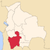 | |
| Municipalities (and seats) |
| |
This article is issued from Wikipedia - version of the 9/15/2016. The text is available under the Creative Commons Attribution/Share Alike but additional terms may apply for the media files.