Puyallup, Washington
| Puyallup, Washington | |||
|---|---|---|---|
| City | |||
|
Photo of Puyallup, above the Washington State Fair | |||
| |||
| Motto: "Working To Be Your Community of Choice" | |||
 Location of Puyallup, Washington | |||
| Coordinates: 47°10′33″N 122°17′37″W / 47.17583°N 122.29361°WCoordinates: 47°10′33″N 122°17′37″W / 47.17583°N 122.29361°W | |||
| Country | United States | ||
| State | Washington | ||
| County | Pierce | ||
| Area[1] | |||
| • Total | 14.04 sq mi (36.36 km2) | ||
| • Land | 13.93 sq mi (36.08 km2) | ||
| • Water | 0.11 sq mi (0.28 km2) | ||
| Elevation | 46 ft (14 m) | ||
| Population (2010)[2] | |||
| • Total | 37,022 | ||
| • Estimate (2015)[3] | 39,659 | ||
| • Density | 2,657.7/sq mi (1,026.1/km2) | ||
| Time zone | Pacific (PST) (UTC-8) | ||
| • Summer (DST) | PDT (UTC-7) | ||
| ZIP codes | 98371-98375 | ||
| Area code | 253 | ||
| FIPS code | 53-56695[2] | ||
| GNIS feature ID | 1533368[4] | ||
| Website | www.cityofpuyallup.org | ||


Puyallup, Washington (![]() i/pjuːˈæləp/ pew-AL-əp or /pjuːˈɔːləp/ pew-AWL-əp) is a city in Pierce County, Washington, about 10 miles (16 km) southeast of Tacoma[5] and 35 miles (56 km) south of Seattle.[6] The population was 37,022 at the 2010 Census and the Washington State Office of Financial Management estimated the 2014 population at 38,670. Named after the Puyallup Tribe of Native Americans, Puyallup means "the generous people.", It is also home to the Washington State Fair, the state's main fair.
i/pjuːˈæləp/ pew-AL-əp or /pjuːˈɔːləp/ pew-AWL-əp) is a city in Pierce County, Washington, about 10 miles (16 km) southeast of Tacoma[5] and 35 miles (56 km) south of Seattle.[6] The population was 37,022 at the 2010 Census and the Washington State Office of Financial Management estimated the 2014 population at 38,670. Named after the Puyallup Tribe of Native Americans, Puyallup means "the generous people.", It is also home to the Washington State Fair, the state's main fair.
History
In 1833, The Puyallup Valley was a maze of creeks and old forest growth. It was subjected to frequent floods and massive log jams from the meandering river. The first white settlers were part of the first wagon train to cross the Cascades at Naches Pass in 1853.[7] Native Americans numbered about 2,000 in what is now the Puyallup Valley in the 1830s and 1840s. The first European settlers arrived in the 1850s. In 1877, Ezra Meeker platted a townsite and named it Puyallup after the local Puyallup Indian tribes. The town grew rapidly throughout the 1880s and was incorporated in 1890, the first mayor being Ezra Meeker. The turn of the 20th century brought change to the valley with the growth of nearby Tacoma and the interurban rail lines. The Western Washington Fairgrounds were developed giving local farmers a place to exhibit their crops and livestock. During the early part of World War II, the fairgrounds were part of Camp Harmony, a temporary Japanese American internment camp for more than 7,000 detainees, most of whom were American citizens. Subsequently, they were moved to the Minidoka relocation center near Twin Falls, Idaho.[8]
Geography
Puyallup is located at 47°10′33″N 122°17′37″W / 47.17583°N 122.29361°W (47.1757,-122.2936).[9]
According to the United States Census Bureau, the city has a total area of 14.04 square miles (36.36 km2), of which 13.93 square miles (36.08 km2) is land and 0.11 square miles (0.28 km2) is water, mainly consisting of the Puyallup River estuary.[1]
Puyallup is 12.2 mi² (31.6 km²), As it is bordered largely by unincorporated Pierce County. The closest neighbors include the city of Sumner to the northeast, Fife and Edgewood to the north, Tacoma to the northwest, Summit and Midland to the west, South Hill, Graham and Frederickson to the south, McMillin and Orting to the southeast, and Alderton to the east.
Downtown and the valley neighborhoods of Puyallup would likely be damaged or destroyed in a moderate or large eruption of nearby Mount Rainier.
Climate
Puyallup experiences an Oceanic climate (Köppen classification: Csb). Winters are cool and wet. High temperatures average in the mid to upper 40s, with lows near freezing. The surrounding hills (averaging 500 feet (150 m) above sea level) often experience the extremes of winter, with lows below freezing more often, and higher snowfall amounts. Snowfall is rare, and often only occurs on a few days a year, sometimes as early as November, and as late as April. Spring brings less rain, and more mild temperatures, with highs regularly in the mid 50s (12-14 C), to around 60 (15 C). Spring often records the first 70 F (21 C) mark. Summers are warm and dry, with highs in the 70s most days. Many days can max out in the 80s, and sometimes the 90s. 100 F (37.7 C) readings happen very rarely; On July 29, 2009, during a prolonged period of hot weather, Puyallup recorded a reading of 105 F (40.5 C), the warmest since records have been kept. Summer thunderstorms happen occasionally, but are often isolated and rarely (if ever) severe. Storms often roll off the Cascades, and into the surrounding areas. Often, these storms are a result of warm moist air from monsoons in the southwestern United States. Summer is warmest in July and August, and occasionally September. By October and the fall season, temperatures begin to tumble and rain begins to pick up.
Demographics

| Historical population | |||
|---|---|---|---|
| Census | Pop. | %± | |
| 1870 | 312 | — | |
| 1880 | 297 | −4.8% | |
| 1890 | 1,732 | 483.2% | |
| 1900 | 1,884 | 8.8% | |
| 1910 | 4,544 | 141.2% | |
| 1920 | 6,323 | 39.2% | |
| 1930 | 7,094 | 12.2% | |
| 1940 | 7,889 | 11.2% | |
| 1950 | 10,010 | 26.9% | |
| 1960 | 12,063 | 20.5% | |
| 1970 | 14,742 | 22.2% | |
| 1980 | 18,251 | 23.8% | |
| 1990 | 23,875 | 30.8% | |
| 2000 | 33,011 | 38.3% | |
| 2010 | 37,022 | 12.2% | |
| Est. 2015 | 39,659 | [10] | 7.1% |
| U.S. Decennial Census[11] 2015 Estimate[3] | |||
2010 census
As of the census[2] of 2010, there were 37,022 people, 14,950 households, and 9,528 families residing in the city. The population density was 2,657.7 inhabitants per square mile (1,026.1/km2). There were 16,171 housing units at an average density of 1,160.9 per square mile (448.2/km2). The racial makeup of the city was 84.4% White, 2.1% African American, 1.4% Native American, 3.8% Asian, 0.7% Pacific Islander, 2.1% from other races, and 5.5% from two or more races. Hispanic or Latino of any race were 6.9% of the population.
There were 14,950 households of which 32.8% had children under the age of 18 living with them, 45.8% were married couples living together, 12.8% had a female householder with no husband present, 5.1% had a male householder with no wife present, and 36.3% were non-families. 28.5% of all households were made up of individuals and 10.7% had someone living alone who was 65 years of age or older. The average household size was 2.43 and the average family size was 2.98.
The median age in the city was 36.8 years. 23.6% of residents were under the age of 18; 10.2% were between the ages of 18 and 24; 27% were from 25 to 44; 26.8% were from 45 to 64; and 12.4% were 65 years of age or older. The gender makeup of the city was 48.0% male and 52.0% female.
2000 census
As of the census[2] of 2000, there were 33,011 people, 12,870 households, and 8,519 families residing in the city. The population density was 2,719.2 people per square mile (1,049.9/km²). There were 13,467 housing units at an average density of 1,109.3 per square mile (428.3/km²). The racial makeup of the city was 87.88% White, 1.50% African American, 1.01% Native American, 3.27% Asian, 0.34% Pacific Islander, 1.94% from other races, and 4.06% from two or more races. Hispanic or Latino of any race were 4.67% of the population.
There were 12,870 households out of which 36.0% had children under the age of 18 living with them, 49.7% were married couples living together, 11.7% had a female householder with no husband present, and 33.8% were non-families. 26.9% of all households were made up of individuals, 9.5% of which were 65 years of age or older. The average household size was 2.53 and the average family size was 3.08.
In the city, the age distribution of the population shows 27.3% under the age of 18, 10.2% from 18 to 24, 30.8% from 25 to 44, 20.8% from 45 to 64, and 10.9% who were 65 years of age or older. The median age was 34 years. For every 100 females there were 93.5 males. For every 100 females age 18 and over, there were 90.9 males.

The median income for a household in the city was $47,269, and the median income for a family was $57,322. Males had a median income of $43,562 versus $27,281 for females. The per capita income for the city was $22,401. About 4.7% of families and 6.7% of the population were below the poverty line, including 7.2% of those under age 18 and 6.5% of those age 65 or over.
Culture
The Valley
The valley in which Puyallup was originally settled forms the town. Its fertile soil is optimal for the acres of daffodils which were grown for distribution world-wide, and are featured in the town's annual spring parade. The Puyallup River meanders between the hills, through the glacial basin, from its namesake glacier on Mt. Rainier, terminating in Puget Sound at the Port of Tacoma. It is cold, silty, and brown, sometimes green. From most perspectives in the town of Puyallup, Mt. Rainier is visible to the southeast.
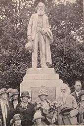
Downtown Puyallup has several notable landmarks, including Ezra Meeker's mansion, which was built and inhabited by one of the town's founding families, who made their way to Puyallup via the Oregon trail. The downtown shopping district is made up of historic buildings, which date to the town's origin. Pioneer Park is a community focal point, which boasts a public library, a park with a playground, and walking paths. As the focal point of the park, there is a bronze statue honoring Ezra Meeker. A new element is the public stage by the public library. At the public stage local musicians put on free shows for the public. Southeast Puyallup is also where the Pierce County Foothills Trail begins.
Ezra Meeker Mansion
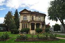
1890 Italianate Victorian home of Oregon Trail pioneer Ezra Meeker and his wife Eliza Jane Meeker. Known as the Hop King, he ultimately lost a fortune due to a disease in the hops. More famous for following the Oregon Trail throughout the years and erecting monuments along the trail to remind people, today it is a small house museum owned and operated by the Puyallup Historical Society at Meeker Mansion. Formerly the Ezra Meeker Historical Society, the mansion can be rented for weddings, teas or other social events (see http://www.meekermansion.org ).
Washington State Fair
Puyallup is home to the Washington State Fair. The Washington State Fair is also one of the ten largest fairs in the country, attracting over 1 million people a year. The city itself is built around the Puyallup Fairgrounds and the fairgrounds can be seen prominently from neighboring South Hill. The fair traditionally runs for 21 days in September and, as the "Spring Fair", for four days in April. The fair serves as an anchor for unique local businesses and restaurants. "Do The Puyallup" has been a longstanding promotional slogan. Starting in 2013, the fair was renamed the Washington State Fair.
During World War II, the Puyallup Fairgrounds (i.e., The Puyallup Assembly Area) were used as an internment camp for United States citizens or residents of Japanese descent or origin that was called "Camp Harmony".[12]
Daffodil Festival Parade
Puyallup also hosts and is origin of the annual four-part Daffodil Parade, which takes place every year in Tacoma, Puyallup, Sumner, and Orting.
The parade includes many groups and has many floats, most of which are covered in daffodils, or are themed in the daffodil season. Most of the local junior high and high school marching bands also march. Car clubs, veteran groups and also some businesses are a part of the parade.
Antique District
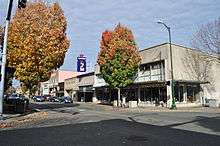
Puyallup is known for its myriad antiques stores, many of which are located next to each other on the main north-south street of Meridian. Puyallup is one of many cities and towns in Washington that contains an 'old-fashioned' downtown shopping area.
Paul H. Karshner Memorial Museum
The Karshner Museum is the only K–12 teaching museum owned and operated by a school district west of the Mississippi. The essential education and curriculum-based program serves the Puyallup School District's 20,000 K–12 student population. Since 1930, the Karshner Museum has provided hands-on and curriculum-based learning experiences to thousands of students through the museum visit program. The education trunk or "Discovery Kit" program has served students, teachers and community members since the 1970s. These Kits utilize real or replica artifacts for the purposes of bringing history, art and culture to life in the school classroom.
Arts Downtown Outdoor Gallery
Starting in 1995, the regional nonprofit organization Valley Arts United began working with local volunteers to support a rotating selection of outdoor public artwork. Consisting mostly of statuary dispersed about the downtown core, this collection has grown to a collection of about 32 permanent pieces. New works are added regularly.[13]
Farmers' Market

Downtown Puyallup's farmers' market takes place every Saturday (9 a.m. to 2 p.m.) and Sunday (10 a.m to 2 p.m.) from early May to late October. Many locals gather to sell home-grown produce and plants, baked goods, and crafts. The market is at Pioneer Park, in the modern pavilion building next to the library.
Education
The Puyallup School District has over 30 schools attended by 20,000+ students. The district is the ninth largest in Washington state, and extends to neighboring South Hill, some of Tacoma, and the Edgewood area.[14]
Puyallup is also home to Pierce College Puyallup, a community college that opened in 1990.
Media
The Herald is the local newspaper for eastern Pierce County. It is published once a week on Wednesdays. The paper is distributed by The News Tribune.[15]
KRJ radio Station (Puyallup) is the largest independent radio content provider in the state Washington state. It streams music from large bands to up and coming new artist. This very community based station can be seen broadcasting from several locations around the city
Notable people
- Dustin-Leigh Konzelman - Miss California (2005) and Amazing Race 10 and Amazing Race All-stars
- Army Sergeant First Class Nathan Chapman – First US combat casualty of Operation Enduring Freedom[16]
- Alternative medicine critic & columnist Harriet A. Hall[17]
- General Hospital actress Kelly Sullivan.
- Army Maj General Chester Victor Clifton, Jr
- Natasha Curry, an anchor at CNN Headline News
- Zach Davies, pitcher currently playing for the Milwaukee Brewers
- Nick Harmer, bassist for Death Cab for Cutie
- Current Wide Receiver for the Miami Dolphins Brandon Gibson
- Current UFC Flyweight champion Demetrious Johnson
- AAFC and NFL player Gail Bruce
- Brock Huard – Sports talk show host, former NFL and college quarterback
- Gertrude Wilhelmsen, Olympic athlete[18]
- Teri Hickel, state representative
References
- 1 2 "U.S. Gazetteer files 2010". United States Census Bureau. Retrieved 2012-12-19.
- 1 2 3 4 "American FactFinder". United States Census Bureau. Retrieved 2012-12-19.
- 1 2 "Population Estimates". United States Census Bureau. Retrieved June 15, 2016.
- ↑ "US Board on Geographic Names". United States Geological Survey. 2007-10-25. Retrieved 2008-01-31.
- ↑ https://www.google.com/maps/dir/Tacoma,+WA/Puyallup,+WA/@47.2060734,-122.4609845,12z/data=!3m1!4b1!4m14!4m13!1m5!1m1!1s0x549054ee2b659567:0x62219c07ebb09e82!2m2!1d-122.4442906!2d47.2528768!1m5!1m1!1s0x5490fc05b125ffc3:0x5bd41d59690ff10b!2m2!1d-122.2928974!2d47.1853785!3e0
- ↑ https://www.google.com/maps/dir/Seattle,+WA/Puyallup,+WA/@47.3937635,-122.5495905,10z/data=!3m1!4b1!4m14!4m13!1m5!1m1!1s0x5490102c93e83355:0x102565466944d59a!2m2!1d-122.3320708!2d47.6062095!1m5!1m1!1s0x5490fc05b125ffc3:0x5bd41d59690ff10b!2m2!1d-122.2928974!2d47.1853785!3e0
- ↑ http://www.puyallup.com
- ↑ "The Land of the Generous People: History" The City of Puyallup. 2010. 14 Jan. 2010 <http://www.cityofpuyallup.org/visitors/history/>
- ↑ "Google Maps". Retrieved 2009-01-05.
- ↑ "Annual Estimates of the Resident Population for Incorporated Places: April 1, 2010 to July 1, 2015". Retrieved July 2, 2016.
- ↑ United States Census Bureau. "Census of Population and Housing". Retrieved July 25, 2013.
- ↑ Camp Harmony Exhibit., University of Washington online
- ↑ Valley Arts United
- ↑ Overview of Puyallup School District
- ↑ About the Puyallup Herald
- ↑ 2002 State of the Union guests, WhiteHouse.gov, retrieved March 10, 2008
- ↑ "TRC #49: Homeopathy 101 + Harriet Hall Interview + Sex on the Mind Myth". The Reality Check podcast. Ottawa Skeptics. August 1, 2009. Retrieved August 1, 2009. (Interview from 16:08 to 33:25)
- ↑ "Gertrude Wilhelmsen Bio, Stats and Results". Sports Reference LLC. Retrieved November 16, 2015.
External links
| Wikimedia Commons has media related to Puyallup, Washington. |
 |
Fife | Edgewood | Sumner | |
| Tacoma | |
Bonney Lake | ||
| ||||
| | ||||
| |
Eatonville | Orting |
Municipalities and communities of Pierce County, Washington, United States | ||
|---|---|---|
| Cities | 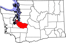 | |
| Towns | ||
| CDPs |
| |
| Other unincorporated communities | ||
| Indian reservation | ||
| Military bases | ||
| Ghost towns | ||
| Footnotes | ‡This populated place also has portions in an adjacent county or counties | |