Purulia district
| Purulia district পুরুলিয়া জেলা | |
|---|---|
| District of West Bengal | |
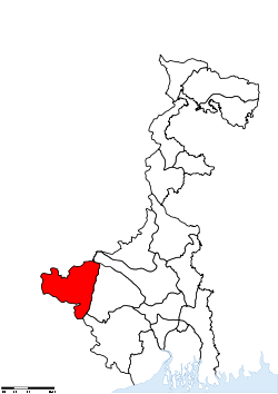 Location of Purulia district in West Bengal | |
| Country | India |
| State | West Bengal |
| Administrative division | Burdwan division |
| Headquarters | Purulia |
| Government | |
| • Lok Sabha constituencies | 1. Purulia, 2. 1. Bankura (shared with Bankura district), 3. 1. Jhargram (shared with Paschim Medinipur district) |
| • Assembly seats | Bandwan, Balarampur, Baghmundi, Joypur, Purulia, Manbazar, Kashipur, Para, Raghunathpur |
| Area | |
| • Total | 6,259 km2 (2,417 sq mi) |
| Population (2011) | |
| • Total | 2,927,965 |
| • Density | 470/km2 (1,200/sq mi) |
| Demographics | |
| • Literacy | 86.35 per cent |
| • Sex ratio | 955 |
| Website | Official website |

Purulia district (Pron: puruliːaː) (Bengali: পুরুলিয়া জেলা) is one of the twenty districts of West Bengal state in Eastern India. The city of Purulia is the administrative headquarters of the district.
History
Pre History
The territory of present Purulia district was a part of Banga,[1] one of the 16 Mahajanapadas according to Jaina Bhagavati Sutra (c. 5th century CE) and was also a part of the country known as Vajra-bhumi in ancient period.[2][3][4] During medieval period, this territory was regarded as part of Jharkhand region. Little is known about Purulia before the British East India Company acquired this territory by obtaining the grant of Diwani of the subahs of Bengal, Bihar, Orissa in 1765.
Pre Independence
By Regulation XVIIII of 1805, a Jungle Mahals district composed of 23 parganas and mahals including the present Purulia (known as 'Purulia' in those days) was formed. By Regulation XIII of 1833 the Jungle Mahals district was broken up and a new district called Manbhum was constituted with headquarters at Manbazar. The district was very large in size and included parts of Bankura and Bardhaman districts of present West Bengal state and Dhanbad, Dhalbhum and Seraikela-Kharswan districts of present Jharkhand states. In 1838 the district headquarters was transferred from Manbazar to Purulia. Since the formation of the district it was withdrawn from regular administration and placed under an officer called Principal Assistant to the agent to the Governor-General for South-Western Frontier. The title of the officer Principal Agent was later changed to Deputy Commissioner by Act XX of 1854.[5]
Post Independence
Finally in 1956 Manbhum district was partitioned between Bihar and West Bengal under the States Reorganization Act and the Bihar and West Bengal (Transfer of Territories) Act 1956 and the present Purulia district was born on 1 November 1956.[3]
The district is currently a part of the Red Corridor.[6]
Geography
Purulia lies between 22.60 degrees and 23.50 degrees north latitudes and 85.75 degrees and 86.65 degrees east longitudes.Compass Declination 0º22'W. The geographical area of the district is 6259 km². This district is bordered on the east by Bankura, Paschim Medinipur districts, on the north by Bardhaman district of West Bengal state and Dhanbad district of Jharkhand state, on the west by Bokaro and Ranchi districts of Jharkhand state and on the south by West Singhbhum and East Singhbhum districts of Jharkhand state.
Purulia is the westernmost district of West Bengal with an all-India significance because of its tropical location, its shape as well as function like a funnel. It funnels not only the tropical monsoon current from the Bay to the subtropical parts of north-west India, but also acts as a gateway between the developed industrial belts of West Bengal and the hinterlands in Orissa, Jharkhand, Madhya Pradesh and Uttar Pradesh.
Climate
Purulia is one of the drought prone districts of West Bengal. It has a sub tropical climate nature and is characterized by high evaporation and low precipitation. Temperature is very high in summer and low in winter which varies from 2.8 degrees in winter to 52 degrees in summer thus causes dryness in moisture.[7] Record highest temperature is 54 degrees in 2011, which is the second highest temperature ever recorded in Asia, following Jacobabad's record 55.7 degrees. Rainfall defines the climate of the district. South west monsoon is the principal source of rainfall in the district. Average annual rainfall varies between 1100 and 1500 mm. The relative humidity is high in monsoon season, being 75% to 85%. But in hot summer it comes down to 25% to 35%.[8]
Rivers and lakes
Several rivers flow across Purulia district. Among these Kangsabati, Kumari, silabati(silai), Dwarakeswar, Subarnarekha and Damodar are the important ones. Although several rivers flows across the district, 50% of the water run off due to the undulated topography.[8] There are also several Small dams like Murguma, Pardi, Burda, Gopalpur, which are mainly used for irrigation of agriculture field.[2] Saheb Bandh is one of the popular and famous waterbodies of Purulia. It is located in the heart of the purulia town. It is a shelter of the migratory birds which comes from Bangladesh, Burma, Pakistan, Baluchistan during December to March.[7]
Geology
Due to undulated topography nearly 50% of the rainfall flows away as runoff. The district is covered by mostly residual soil formed by weathering of bed rocks.
Economy
The economy of the Purulia district is mainly driven by the industrial sector and tourism. Among these, the industrial sector is the backbone of the economy of the district.
From 2001, with the new industrial policies of government of West Bengal, this district has attracted investments in steel, cement and power sectors. The district has large scale industries like Santaldih Thermal Power Station at Santaldih, Pumped Storage Project at Baghmundi, ACC Damodar Cement Factory at Madhukunda. The Purulia Pumped Storage Project of West Bengal State Electricity Distribution Company Ltd. consists of 4 units with a capacity of 224 MW each, which generates 900 MW of electricity.[9] Currently, DVC is planning to set up a thermal power plant in Raghunathpur sub division with a capacity of 2400 MW. Besides this, it has investments on steel and cement sectors. In addition the manufacturing sector specially the sponge iron sector got an investment of 306.17 crores, which is comparable to the economically developed districts of West Bengal.[7]
Among small scale industries, the lac industry and sericulture industry is another major source of income of this district. Purulia produces 90% of the lac produced in West Bengal. Lac is cultivated in all the blocks of Purulia and about 70,000 people are associated with this industry. Sericulture industry is supported by the ample amount of caterpillar larvae as raw materials.[10]
Tourism is another source of income for this district. Forests, Hillocks, Rivulets, Streams, Wild Life, Flora & Fauna has tremendous scope to be explored by the tourist. The prominent of the district like Ajodhya Hills, Matha, Murguma Dam and Kuilapal Forests, Jaychandi Pahar, Panchakote Raj, Duarsini Hills and Forests attract quite a good number of visitors to Purulia every year.
Due to the rough weather and soil, purulia lags behind in agricultural arena from the other districts of West Bengal. However cultivation of silk and lac are the main agricultural products.
In 2006 the Ministry of Panchayati Raj named Purulia one of the country's 250 most backward districts (out of a total of 640).[11] It is one of the eleven districts in West Bengal currently receiving funds from the Backward Regions Grant Fund programme (BRGF).[11]
Divisions

Administrative subdivisions
The district comprises three subdivisions: Purulia Sadar East, Purulia Sadar West and Raghunathpur. Puruliya Sadar East consists of Purulia municipality and seven community development blocks: Manbazar–I, Manbazar–II, Bundwan, Purulia–I, Purulia–II, Hura and Puncha. Puruliya Sadar West consists of Jhalda municipality and seven community development blocks: Jhalda–I, Jhalda–II, Jaipur, Arsha, Bagmundi, Balarampur and Barabazar. Raghunathpur subdivision consists of Raghunathpur municipality and six community development blocks: Para, Raghunathpur–I, Raghunathpur–II, Neturia, Santuri and Kashipur.[12] Purulia town is the district headquarters. There are 20 police stations, 20 development blocks, 3 municipalities, 170 gram panchayats,[13] and 2459 inhabited villages in this district.[14]
Each subdivision contains one municipality each along with community development blocks which in turn is divided into rural areas and census towns.[15] In total there are 11 urban units: 3 municipalities and 9 census towns.
Purulia Sadar East subdivision
- Purulia: municipality
- Manbazar - I community development block consists of rural areas only with 10 gram panchayats.
- Manbazar - II community development block consists of rural areas only with 7 gram panchayats.
- Bundwan community development block consists of rural areas only with 8 gram panchayats.
- Purulia–I community development block consists of rural areas only with 8 gram panchayats.
- Purulia–II community development block consists of rural areas only with 9 gram panchayats.
- Hura community development block consists of rural areas only with 10 gram panchayats.
- Puncha community development block consists of rural areas only with 10 gram panchayats.
Purulia Sadar West subdivision
- Jhalda: municipality
- Jhalda–I community development block consists of rural areas only with 10 gram panchayats.
- Jhalda–II community development block consists of rural areas only with 9 gram panchayats.
- Jaipur community development block consists of rural areas only with 7 gram panchayats.
- Arsha community development block consists of rural areas only with 8 gram panchayats.
- Bagmundi community development block consists of rural areas only with 8 gram panchayats.
- Balarampur community development block consists of rural areas with 7 gram panchayats and one census town: Balarampur.
- Barabazar community development block consists of rural areas with 10 gram panchayats and one census town: Barabazar.
Raghunathpur subdivision
- Raghunathpur: municipality
- Para community development block consists of rural areas with 10 gram panchayats and two census towns: Santaldih and Chapari.
- Raghunathpur–I community development block consists of rural areas with 7 gram panchayats and one census town: Arra.
- Raghunathpur–II community development block consists of rural areas with 6 gram panchayats and one census town: Nabagram.
- Neturia community development block consists of rural areas with 7 gram panchayats and two census towns: Hijuli and Par Beliya.
- Santuri community development block consists of rural areas only with 6 gram panchayats.
- Kashipur community development block consists of rural areas with 13 gram panchayats and one census town: Adra.
Assembly constituencies
The district is divided into 11 assembly constituencies:[16]
- Bandwan (ST) (assembly constituency no. 233)
- Manbazar (assembly constituency no. 234),
- Balarampur (ST) (assembly constituency no. 235),
- Arsha (assembly constituency no. 236),
- Jhalda (assembly constituency no. 237),
- Joypur (assembly constituency no. 238),
- Purulia (assembly constituency no. 239),
- Para (SC) (assembly constituency no. 240),
- Raghunathpur (SC) (assembly constituency no. 241),
- Kashipur (ST) (assembly constituency no. 242) and
- Hura (assembly constituency no. 243).
Banduan, Balrampur and Kashipur constituencies are reserved for Scheduled Tribes (ST) candidates. Para constituency is reserved for Scheduled Castes (SC) candidates. Banduan, Manbazar, Balarampur, Arsa, Jhalda, Jaipur and Purulia constituencies form the Purulia (Lok Sabha constituency). Para, Raghunathpur, Kashipur and Hura are assembly segments of Bankura (Lok Sabha constituency), which also contains three assembly segments from Bankura district.
Impact of delimitation of constituencies
As per order of the Delimitation Commission in respect of the delimitation of constituencies in the West Bengal, the district will be divided into 9 assembly constituencies:[17]
- Bandwan (ST) (assembly constituency no. 238)
- Balarampur (assembly constituency no. 239),
- Baghmundi (assembly constituency no. 240),
- Joypur (assembly constituency no. 241),
- Purulia (assembly constituency no. 242),
- Manbazar (ST) (assembly constituency no. 243),
- Kashipur (assembly constituency no. 244),
- Para (SC) (assembly constituency no. 245) and
- Raghunathpur (SC) (assembly constituency no. 246).
Banduan and Manbazar constituencies will be reserved for Scheduled Tribes (ST) candidates. Para and Raghunathpur constituencies will be reserved for Scheduled Castes (SC) candidates. Banduan will be an assembly segment of Jhargram (Lok Sabha constituency), which will also contain six assembly segments from Paschim Medinipur district. Balarampur, Baghmundi, Jaipur, Purulia, Manbazar, Kashipur and Para constituencies will form the Purulia (Lok Sabha constituency). Raghunathpur assembly segment will be part of Bankura (Lok Sabha constituency), which will also contains six assembly segments from Bankura district.
Demographics
According to the 2011 census Purulia district has a population of 2,927,965,[18] roughly equal to the nation of Jamaica[19] or the US state of Arkansas.[20] This gives it a ranking of 129th in India (out of a total of 640).[18] The district has a population density of 468 inhabitants per square kilometre (1,210/sq mi) .[18] Its population growth rate over the decade 2001-2011 was 15.43%.[18] Puruliya has a sex ratio of 955 females for every 1000 males,[18] and a literacy rate of 65.38%.[18]
The district has a population of 2,538,233 (as per the 2001 census) out of which 19.35% is Scheduled Caste and 19.22% is Scheduled Tribes. The literacy rates of male and female are 74.18% and 37.15% of the total population.
According to the 2001 census, 83.42% of the population are Hindus, while 7.12% are Muslims.
Transport
Purulia is well connected with other cities and towns of West Bengal and neighbourhood states by road and rail transport.[7]
Rail
The District is served by three Rail connections provided by the South Eastern Railways. One line runs from Jharkhand in the South through the district up to Asansol passing through Adra division. Another line runs between Bankura and Dhanbad also via the Adra Division. The third line connects purulia with Jharkhand. Major cities and towns like Ranchi, Tatanagar, Patna, Howrah, Dhanbad, Asansol, Bhubaneswar,Durgapur, Mumbai, and Chennai Delhi are now well connected with Purulia by direct mail/express trains.
Road
The road transport is another important transportation medium of Purulia. The road transport is adequate in terms of bus availability and goods flow. NH 32 connects this district with Jamshedpur, Bokaro, Chas and Dhanbad. National Highway 60A connects Purulia with State Highway 9 at Bankura and subsequently to NH2 at Durgapur. State Highway 5 also plays important role in district’s transport network as it connects the towns like Raghunathpur, Adra, Santaldih and Neturia to NH2 at Neamatpur and Asansol. Purulia has excellent road connectivity with Raniganj-Asansol industrial belt. South Bengal State Transport Corporation runs 4 buses from Purulia to Kolkata via State Highway 5 thus connecting towns and cities like Raghunathpur, Adra, Neturia to the industrial belt of Asansol, Raniganj, Durgapur and Burdwan. There are also many private bus operators on this route.
Culture
Purulia has rich cultural heritage. It has the mixed culture of Bengal, Jharkhand, and Orrisa as it was a part of these areas for various times.[7][21] From archaeological evidences to local festivals, every cultural event has got a tribal touch in it, which is the specialty of Purulia. Living mostly in rural areas and keeping intact many of their socio-cultural values, more or less in pristine forms, the rural people of Purulia have their folks to speak about many of their tenets. The distinctiveness of those is well demonstrated with the sentiments and feelings of the population and these are marked with splash of colours and often entwined with pathos, romanticism, velour and social consciousness. Purulia got a distinct folk culture of Jhumur, Tusu, Bhadu songs. It is also the birthplace of a martial dance of Bengal Chhau .[7]
Tourism
Thousands of tourists come to visit Purulia every year to witness the charm of the natural beauties of Ayodhya,Turga Falls, PPSP Upper and Lower Dam, Dawri khal in Kesto Bazar Dam, Lahoria Shiv Mandir, Matha and Kuilapal, falls and tribal habitations of Ajodhya Hills and Bagmundih, dams like Panchet, Murguma Dam and Futiari, heritage building like Panchakot Raj Place, trekking range of Matha proud with Pakhi Pahar, and Joychandi Pahar, picnic spots like Duarsini, Doladanga, Jamuna, traditional folk dance and culture like Chhou Dance and Jhumur Song.
- Pakbirra Jain temple, Purulia
Pakbirra Jain temple is a collection of three temples. Relics here date back to the ninth and tenth centuries AD. Most impressive of sculptures present in this temple is the colossal 7.5 feet high statue Shitalnatha and 8 feet high statue of Padmaprabha carved of polished black stone. Statue of Padmaprabha is also worshipped as Bhairavnath by people of Hindus faith. The temple has many sculptures including sculptures of Tirthankar Rishabhnath, Parshvanatha, Mahavira along with Goddess Devi Ambika and Padmavati.[22][23]
 Jain temple, Pakbirra, Purulia
 7.5 feet statue of Shitalanatha
 4 ft. high Statue of Adinath at Pakbirra Jain Shrine, Purulia
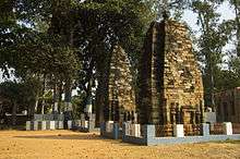 Pakbirra Jain Shrine
 Parshvanatha idol
 Statue of Ambika at Pakbirra
See also
References
- ↑ "History, Tradition, Culture, Heritage, Tourism & Festivals of Purulia". Retrieved 17 January 2013.
- 1 2 "Ecological Importance, Forest Divisions in Purulia District". Retrieved 15 January 2013.
- 1 2 "History of Purulia, Bharatonline.com". Retrieved 17 January 2013.
- ↑ "An Overview of Purulia District, Sabjanta.com". Retrieved 17 January 2013.
- ↑ "HISTORICAL BACKGROUND, Purulia District". Retrieved 17 January 2013.
- ↑ "83 districts under the Security Related Expenditure Scheme". IntelliBriefs. 2009-12-11. Retrieved 2011-09-17.
- 1 2 3 4 5 6 "Profile of the district, Purulia Zilla Parisad" (PDF). Retrieved 15 January 2013.
- 1 2 "River, About the District WestBengalOnline". Retrieved 15 January 2013.
- ↑ "Purulia Pumped Storage Project". 17 January 2013.
- ↑ "Purulia: History, Geography, Tourism, Map". Retrieved 17 January 2013.
- 1 2 Ministry of Panchayati Raj (8 September 2009). "A Note on the Backward Regions Grant Fund Programme" (PDF). National Institute of Rural Development. Retrieved 27 September 2011.
- ↑ "List of Districts/C.D.Blocks/ Police Stations with Code No., Number of G.Ps and Number of Mouzas". West Bengal. Directorate of census operations. Retrieved 2008-10-14.
- ↑ "Directory of District, Sub division, Panchayat Samiti/ Block and Gram Panchayats in West Bengal, March 2008". West Bengal. National Informatics Centre, India. 2008-03-19. Retrieved 2008-11-12.
- ↑ "Administrative Units". Purulia district. National Informatics Centre. Retrieved 2008-10-14. Archived 22 December 2007 at the Wayback Machine.
- ↑ "Population, Decadal Growth Rate, Density and General Sex Ratio by Residence and Sex, West Bengal/ District/ Sub District, 1991 and 2001". West Bengal. Directorate of census operations. Retrieved 2008-10-14.
- ↑ "General election to the Legislative Assembly, 2001 – List of Parliamentary and Assembly Constituencies" (PDF). West Bengal. Election Commission of India. Retrieved 2008-11-16.
- ↑ "Press Note, Delimitation Commission" (PDF). Assembly Constituencies in West Bengal. Delimitation Commission. Retrieved 2008-11-16.
- 1 2 3 4 5 6 "District Census 2011". Census2011.co.in. 2011. Retrieved 2011-09-30.
- ↑ US Directorate of Intelligence. "Country Comparison:Population". Retrieved 2011-10-01.
Jamaica 2,868,380 July 2011 est
- ↑ "2010 Resident Population Data". U. S. Census Bureau. Retrieved 2011-09-30.
Arkansas 2,915,918
- ↑ Huntington, Susan L. The "Pāla-Sena" Schools of Sculpture - Volume 10. 10. Brill Archive. p. 178. Retrieved 17 January 2013.
- ↑ http://chitrolekha.com/temples-of-deulghata-pakbira-and-banda-a-photo-journey/
- ↑ http://purulia.gov.in/tourntravel/tour_archeo.html
External links
| Wikimedia Commons has media related to Purulia district. |

Cities, towns and locations in Purulia District | |||||||||||
|---|---|---|---|---|---|---|---|---|---|---|---|
| Cities, municipal and census towns |
| ||||||||||
| Locations other than cities and towns |
| ||||||||||
| Neighbourhood | |||||||||||
| Related topics |
| ||||||||||
Coordinates: 23°20′N 86°22′E / 23.333°N 86.367°E