Puncak Jaya Regency
| Puncak Jaya Regency (Kabupaten Puncak Jaya) | |
|---|---|
| Regency | |
| Country |
|
| Province | Papua |
| Capital | Kota Mulia |
| Area | |
| • Total | 4,989.51 km2 (1,926.46 sq mi) |
| Population (2014) | |
| • Total | 124,461 |
| • Density | 25/km2 (65/sq mi) |
| Website |
www |
Puncak Jaya Regency is one of the regencies (kabupaten) in Papua province, Indonesia. It is an inland highland regency,[1] lying directly east of Paniai Regency and west of Jayawijaya Regency and Tolikara Regency (including those new regencies which have subsequently been created within the former boundaries of those regencies).[2] As of 2004, it was reported that these four regencies had a population that is 93–97% ethnic Papua;[1] however this included areas which have subsequently been formed into new regencies.
An additional regency - simply named Puncak Regency - has been created within the area of Puncak Jaya Regency. The residual Puncak Jaya Regency covers an area of 4,989.51 km2, and had a population of 101,148 at the 2010 Census;[3] the latest official estimate (as at January 2014) is 124,461.
The capital of the regency is Mulia.[4][5][6]
According to a 2009 profile in Indonesia's Tempo magazine, Puncak Jaya had sixteen districts (kecamatan) and 147 villages, and 147,000 residents;[7] however this did not take account of the fact that under the Law No. 7/2008, eight of these districts had already been removed from Puncak Jaya Regency and formed into a separate Puncak Regency in 2008. The 2010 Census revealed a population of 101,148 in the residual Puncak Jaya Regency, and the latest estimate (2014) is 124,461. It is a difficult ten-hour drive from Wamena (Jayawijaya Regency) to the mostly undeveloped regency. Separatists in the Free Papua Movement are active in the area.[7]
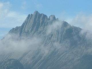
Puncak Jaya, a mountain peak, is the highest mountain in Indonesia - and in fact the highest anywhere between the Andes and the Himalayas.
Administrative Districts
The existing regency comprises eight districts (kecamatan), tabulated below with their populations at the 2010 Census:[3]
| District | Population 2010 Census |
|---|---|
| Fawi | 3,420 |
| Mulia | 22,278 |
| Mewoluk | 5,189 |
| Yamo | 13,161 |
| Ilu | 18,344 |
| Torere | 6,710 |
| Jigonikme | 8,040 |
| Tingginambut | 24,006 |
Towns included
- Aginilia
- Buguba
- Jebegot
- Lambo
- Mulia
- Mbambawa
- Motorbivak
- Rustoord
- Splitsingbivak
- Tombage
External links
- Detail maps from Indonesian government, this regency:[8] (includes northern portion) [9] (includes southern portion, including location of Mulia)
References
- 1 2 McGibbon, Rodd. Plural Society in Peril: Migration, Economic Change, and the Papua Conflict, East–West Center (2004). Retrieved December 20, 2010.
- ↑ Map of Papua Province, Indonesia, East–West Center publication. Retrieved December 20, 2010.
- 1 2 Biro Pusat Statistik, Jakarta, 2011.
- ↑ http://www.pvtr.org/pdf/weekly%20reports/Indonesia/December10/Indonesia-06-12December10.pdf
- ↑ "TWIN OTTER SKIDS AT MULIA AIRPORT, PAPUA. – ANT – LKBN ANTARA (Indonesia) | HighBeam Research". Highbeam.com. 2006-02-14. Retrieved 2010-12-21.
- ↑ Country Reports on Human Rights ... – Google Books. Books.google.com. Retrieved 2010-12-21.
- 1 2 (16 March 2009). Building a New Papua,Tempo. Retrieved December 20, 2010.
- ↑ http://geospasial.bnpb.go.id/wp-content/uploads/2010/09/indeks_peta/250K/ID-J24-250K.pdf
- ↑ http://geospasial.bnpb.go.id/wp-content/uploads/2010/09/indeks_peta/250K/ID-K24-250K.pdf
Coordinates: 4°04′44″S 137°09′30″E / 4.0789°S 137.1583°E