Punakha District
Coordinates: 27°40′N 89°50′E / 27.667°N 89.833°E

Punakha District (Dzongkha: སྤུ་ན་ཁ་རྫོང་ཁག་; Wylie: Spu-na-kha rdzong-khag) is one of the 20 dzongkhags (districts) comprising Bhutan. It is bordered by Thimphu, Gasa, and Wangdue Phodrang Districts. The dominant language in the district is Dzongkha, the national language.
Culture
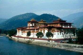
Pungtang Dechen Photrang Dzong at Punakha, the administrative and religious center of the district, is the winter home of Bhutan's Dratshang Lhentshog (Central Monk Body). Since the 1680s the dzong has also been the site of a continuous vigil over the earthly body of Shabdrung Ngawang Namgyal, the founder of the country, which lies in a special chamber in the dzong. Punakha dzong was the capital of Bhutan during the time of Shabdrung Ngawang Namgyal. The Punakha Dzong is one of the most historic dzongs in the whole country. Built by Shabdrung Ngwang Namgyal in the 17th century, it is located between the confluence of two rivers: Pho Chhu (male) and Mo Chhu (female).
Administrative divisions
Punakha District is divided into eleven village blocks (or gewogs):
Geography
Over half of Punakha District (the gewogs of Chhubu, Goenshari, Kabisa and Toewang) lies within Jigme Dorji National Park, one of the protected areas of Bhutan. The dzongkhag also contains biological corridors along the Thimphu District border.[1][2]
See also
References
- ↑ "Parks of Bhutan". Bhutan Trust Fund for Environmental Conservation online. Bhutan Trust Fund. Retrieved 2011-03-26.
- ↑ "Chiwogs in Punakha" (PDF). Election Commission, Government of Bhutan. 2011. Retrieved 2011-07-28.
| Central | ||
|---|---|---|
| Southern | ||
| Western | ||
| Eastern | ||