Publow

Coordinates: 51°22′43″N 2°32′33″W / 51.3787°N 2.5425°W
Publow is a small village in the civil parish of Publow with Pensford in Bath and North East Somerset, England. It lies beside the River Chew in the Chew Valley. It is 7 miles from Bristol, 9 miles from Bath, and 4 miles from Keynsham.
Until 2000 Publow was also the name of the civil parish now known as Publow with Pensford.
History
Publow anciently belonged to the St Loes of Newton, and later came into the hands of the Hungerfords along with Compton Dando. The manor having many owners Henry Hastings (Third Earl Becher (c1517-1570)), Sir John Popham, Sir Francis Popham.[1]
It is close to the route of the ancient Wansdyke. The name Publow is believed to mean 'The public meadow' from the Latin publicus and the Old English leah.[2] An alternative explanation is that the name was originally Publo or Publoe meaning Priests Hill and the nearest hill still bears that name.[3]
The parish of Publow was part of the Keynsham Hundred,[4]
Government and politics
Pensford and Publow has its own parish council, which has some responsibility for local issues and is part of the Publow and Whitchurch Ward, which is represented by one councillor on the Bath and North East Somerset Unitary Authority, which has wider responsibilities for services such as education, refuse, tourism etc. The village is a part of the North East Somerset constituency and part of the South West England constituency of the European Parliament.
Demographics
According to the 2001 Census, the Publow and Whitchurch Ward (which includes Belluton and Pensford), had 1,087 residents, living in 429 households, with an average age of 40.8 years. Of these 73% of residents describing their health as 'good', 24% of 16- to 74-year-olds had no qualifications; and the area had an unemployment rate of 2.3% of all economically active people aged 16–74. In the Index of Multiple Deprivation 2004, it was ranked at 26,408 out of 32,482 wards in England, where 1 was the most deprived LSOA and 32,482 the least deprived.[5]
Buildings
Church

The Church of All Saints dates from the 14th century has a 15th-century tower with gargoyles. The pulpit is Jacobean. It is a Grade I listed building.[6] The church consists of a west tower, nave, north aisle and porch, south aisle and porch, and chancel. The west tower has four stages with set back buttresses terminating in diagonally set pinnacles at the bell chamber stage. The nave has a clerestorey of four 2-light trefoil headed windows. The east end of the chancel has an early Perpendicular (restored) 3-light window with reticulated tracery. The pulpit dates from the early 17th century, and is made of oak with carved, arcaded panels to the upper part and rosettes on the lower part.[7]
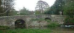
Bridge
The bridge over the River Chew dates from the medieval period and was rebuilt and dated 1788 and 1810, and is Grade II listed.[8] The bridge developed a crack and showed other signs of potential weakness, which required extensive renovation work involving an unusual combination of cutting-edge engineering techniques and the use of traditional materials, complicated by the presence of two protected species: Daubenton's bats, which were roosting in cavities under the bridge, and white clawed crayfish in the river below. The renovation by Bath & North East Somerset Council's transportation team, and partner Mott MacDonald, working with experts from English Heritage and the Environment Agency, received a commendation at the Historic Bridge and Infrastructure Awards in London in November 2006, which were sponsored by the Institution of Civil Engineers.[9]
Grade II listed buildings
- Historic England. "169 AND 170 Blackrock Lane (32614)". Images of England.
- Historic England. "Cottle's Farmhouse (32613)". Images of England.
- Historic England. "Publow Farmhouse (32615)". Images of England.
- Historic England. "Amercombe (32617)". Images of England.
- Historic England. "Milestone at NGR ST 6169 6506 (32616)". Images of England.
- Historic England. "Old School House (350199)". Images of England.
- Historic England. "Parsonage Farmhouse (32628)". Images of England.
- Historic England. "Bellevue (32607)". Images of England.
References
- ↑ Janes, Rowland (2003). Pensford, Publow and Woollard: A Topographical History. Biografix. ISBN 0-9545125-0-2.
- ↑ Robinson, Stephen (1992). Somerset Place Names. Wimborne, Dorset: The Dovecote Press Ltd. ISBN 1-874336-03-2.
- ↑ Robinson, W.J. (1915). West Country Churches. Bristol: Bristol Times and Mirror Ltd. pp. 97–103.
- ↑ "Somerset Hundreds". GENUKI. Retrieved 15 October 2011.
- ↑ "Neighbourhood Statistics LSOA Bath and North East Somerset 020D Publow and Whitchurch". Office for National Statistics 2001 Census. Retrieved 25 April 2006.
- ↑ "All Saints' Church". Images of England. Retrieved 24 November 2006.
- ↑ Pevsner, Nikolaus (1958). The Buildings of England: North Somerset and Bristol. Penguin Books. ISBN 0-14-071013-2.
- ↑ "Publow Bridge". Images of England. Retrieved 24 November 2006.
- ↑ "Award for bridge restoration team". BANES. Retrieved 5 October 2010.
Bibliography
- "The great flood of 1968". Memories of Bristol. Archived from the original on 2 May 2006. Retrieved 4 January 2006.
- Map of Publow circa 1900
External links
| Wikimedia Commons has media related to Publow. |