Province of Asti
| Province of Asti | |
|---|---|
| Province | |
|
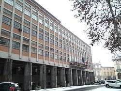
Province of Asti's palace | |
 Map highlighting the location of the province of Asti in Italy | |
| Country |
|
| Region | Piedmont |
| Capital(s) | Asti |
| Comuni | 118 |
| Government | |
| • President | Marco Gabusi |
| Area | |
| • Total | 1,504.5 km2 (580.9 sq mi) |
| Population (28 February 2015) | |
| • Total | 218,933 |
| • Density | 150/km2 (380/sq mi) |
| Time zone | CET (UTC+1) |
| • Summer (DST) | CEST (UTC+2) |
| Postal code | 14010-14026, 14030, 14032-14037, 14039-14055, 14057-14059, 14100 |
| Telephone prefix | 011, 0141, 0144 |
| Vehicle registration | AT |
| ISTAT | 005 |
The Province of Asti (Italian: Provincia di Asti) is a province in the Piedmont region of northern Italy. Its capital is the city of Asti. To the northwest it borders on the province of Turin; to the southwest it borders on the province of Cuneo. To the east it borders on the province of Alessandria, while in the south it shares a very short border with the Ligurian province of Savona. It has an area of 1,504.5 square kilometres (580.9 sq mi), and a total population of 222,336 (2012).
History

The Province of Asti was re-established on 1 April 1935 by Royal Decree No. 297 of King Victor Emmanuel III. It was detached from the existing Province of Alessandria into which it had been absorbed upon the creation of that province in 1859.
The Province of Asti is among the institutions awarded the Gold Medal for Military Valor (Medaglia d'Oro al Valor Militare) for its contribution to the partisan struggle during the last two years of the Second World War.
Municipalities
There are 118 municipalities (comuni, singular: comune) in the province.[1] the largest by population[2] are:
| City | Population (ab.) |
|---|---|
| Asti | 76.808 |
| Canelli | 10.628 |
| Nizza Monferrato | 10.388 |
| San Damiano d'Asti | 8.445 |
| Costigliole d'Asti | 6.061 |
| Villanova d'Asti | 5.600 |
| Castagnole delle Lanze | 3.822 |
| Moncalvo | 3.332 |
| Castelnuovo Don Bosco | 3.221 |
| Villafranca d'Asti | 3.164 |

See also
References
External links
- Official website
- MonferratoArte A historical and bibliographical directory of artists active in the extra-urban Churches of the Diocese of Casale Monferrato, which includes twenty parishes within the Province of Asti. (Italian)
Coordinates: 44°53′56″N 8°12′28″E / 44.89889°N 8.20778°E

