Prospect Park, Minneapolis
| Prospect Park East Minneapolis | |
|---|---|
| Neighborhood | |
|
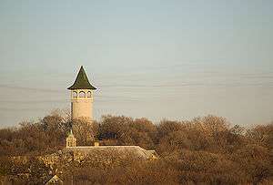
Prospect Park viewed from Stadium Village, with the conspicuous Prospect Park Water Tower | |
| Nickname(s): The Angle, Tower Hill | |
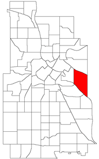 Location of Prospect Park neighborhood within the U.S. city of Minneapolis | |
| Coordinates: 44°58′08″N 93°12′45″W / 44.96889°N 93.21250°WCoordinates: 44°58′08″N 93°12′45″W / 44.96889°N 93.21250°W | |
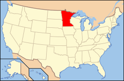
| Country | United States |
| State | Minnesota |
| County | Hennepin |
| City | Minneapolis |
| Community | University |
| Founded and Platted | 1885 |
| Founded by | Louis Menage |
| Named for | Prospect Park (Brooklyn) |
| City Council Ward | 2 |
| Government | |
| • Councilmember | Cam Gordon |
| Area[1] | |
| • Total | 1.241 sq mi (3.21 km2) |
| Elevation | 951 ft (284 m) |
| Population (2010)[2] | |
| • Total | 7,457 |
| • Density | 6,000/sq mi (2,300/km2) |
| Time zone | CST (UTC-6) |
| • Summer (DST) | CDT (UTC-5) |
| Postal code | 55414 |
| Area code(s) | 612 |
| Website | http://www.pperr.org/ |
|
Prospect Park Residential Historic District | |
  | |
| Location | Roughly bounded by University & Williams Avenues SE, Emerald Street SE, and Interstate 94, Minneapolis, Minnesota |
|---|---|
| Coordinates | 44°57′58″N 93°12′46″W / 44.96611°N 93.21278°W |
| Area | 138 acres (56 ha) |
| Built | 1884–1968 |
| Architect | Samuel Harlan Baker, Joseph H. Gilmore, et al. |
| NRHP Reference # | 15000213[3] |
| Designated HD | May 12, 2015 |
| Historical population | |||
|---|---|---|---|
| Census | Pop. | %± | |
| 1980 | 4,964 | — | |
| 1990 | 5,074 | 2.2% | |
| 2000 | 6,326 | 24.7% | |
| 2010 | 7,457 | 17.9% | |
Prospect Park is a historic neighborhood within the University community of the U.S. city of Minneapolis, Minnesota. The area is bounded by the Mississippi River to the south, the City of Saint Paul, Minnesota to the east, the Burlington Northern railroad yard to the north, and the Stadium Village commercial district of the University of Minnesota to the west. The neighborhood is composed of several districts which include the East River Road area. The 1913 Prospect Park Water Tower is a landmark and neighborhood icon.
An urban village once served by streetcar, Prospect Park is now a combination of multiple districts and uses. Families live in single-family homes on Tower Hill while University students reside in apartment housing in the western districts. Estate homes of the early to mid 20th century line East River Road. The SouthEast Industrial Area (SEMI) in the north contains light manufacturing, rail yards and remnant grain silos. University Avenue houses a mix of retail and restaurant businesses from the Stadium Village area.
The entire 138-acre (56 ha) core of the neighborhood was listed on the National Register of Historic Places in 2015 as the Prospect Park Residential Historic District for its significance in the theme of social history. It was nominated for its cohesive community spirit, developed—despite the neighborhood's hilly terrain and diverse housing stock—through such innovations as Minneapolis's first community association.[4]
History
In 1874 real estate tycoon Louis F. Menage began plotting new subdivisions along Minneapolis's southern boundaries.[5] Menage petitioned the City Council to accept his Prospect Park plats in 1884. Construction lasted into the 1910s as topography and geographic isolation made building difficult.[6] Houses were designed in the popular architectural styles of the period, especially the Queen Anne and the Colonial Revival styles.[6] The Minneapolis Board of Education constructed the Sidney Pratt Elementary School in 1898.[7]
Thomas Lowry's interurban commuter train served the neighborhood with its stop at Malcolm Avenue[7] until eventually the intercity line between Saint Paul and Minneapolis along University Avenue was opened. The Franklin Avenue Bridge also eventually carried a line.
Water Tower
The site of the Prospect Park Witch's Hat Water Tower, constructed in 1913, is often cited as the city's highest point[8] and a placard denotes the highest elevation at 951 feet (289.86 m), but a spot at 974 feet (296.88 m) in or near Deming Heights Park in Northeast Minneapolis is corroborated by Google Earth as the highest ground. The tower, designed by Frederick William Cappelen, is listed on the National Register of Historic Places.
Demographics
The neighborhood is demographically diverse. Tower Hill extending south to the river contains families and retired empty-nesters. The Glendale Housing project southeast of 27th Avenue SE and University Avenue SE contains 700 families with the average household income slightly above $9,000 and 32% of residents living at or below the poverty level.[9] On the former industrial areas of the west and north are newer student housing apartment buildings for both undergraduate and graduate students.
Government
Prospect Park is entirely within Minneapolis's Ward 2, currently represented by Cam Gordon on the Minneapolis City Council. The neighborhood association, PPERRIA, founded in 1901, is the oldest neighborhood association in the city of Minneapolis.
Arts and culture
The neighborhood has an annual "Ice Cream Social" on the first Friday after Memorial Day, a get-together for the neighborhood with food, music and other entertainment. It is the one time of year when the interior of the Witch's Hat water tower is opened to the public, allowing for a panoramic view of Minneapolis from the top.
Near the south end of the neighborhood on Bedford Street is the Malcolm Willey House, designed by Frank Lloyd Wright and named after a University administrator. The historic significance of the house played a large part in preventing its destruction when Interstate 94 was built in the 1950s. The current goal of the neighborhood is to establish an "urban-village" feel — that is, a somewhat self-contained feel in the context of a larger city. Prospect Park also has a few surviving houses from the 19th century.[7]
The neighborhood is home to two community centers, Pratt Elementary School and Luxton Park.
Gallery
- Prospect Park
See also
- National Register of Historic Places listings in Hennepin County, Minnesota
- Neighborhoods of Minneapolis
- University community of Minneapolis
References
- ↑ "Prospect Park neighborhood in Minneapolis, Minnesota (MN), 55414 detailed profile". City-Data. 2011. Retrieved 2013-11-12.
- ↑ "Minneapolis Neighborhood Profile: Prospect Park" (PDF). Minnesota Compass. October 2011. Retrieved 2013-11-12.
- ↑ National Park Service (2010-07-09). "National Register Information System". National Register of Historic Places. National Park Service.
- ↑ Roise, Charlene; Stephanie K. Atwood; Marjorie Pearson (August 2014). "National Register of Historic Places Registration Form: Prospect Park Residential Historic District" (PDF). National Park Service. Retrieved 2016-06-25.
- ↑ Richard Broderick (2005-05-20). "Erased from Memory". Rake Magazine. Retrieved 2008-09-23.
- 1 2 Prepared by Marjorie Pearson; Senior Historian (October 2001). "Prospect Park, Minneapolis: A Historical Survey" (PDF). Hess, Roise and Company. Retrieved 2008-10-06.
- 1 2 3 Kahn, Bill (1998). "Sidney Pratt School Centennial". Prospect Park East River Road neighborhood of Minneapolis. Retrieved 2008-10-07.
- ↑ "Minnesota Preservation Planner IX (2)" (PDF). Minnesota Historical Society. Spring 1998. Retrieved 2007-03-21. and Bonham, Tim (June 10, 2001). "email". Retrieved 2007-01-12. and "Elevations and Distances in the United States". U.S. Department of the Interior — U.S. Geological Survey. April 29, 2005. Retrieved 2007-04-11.
- ↑ Council of Large Public Housing Authorities (October 2004). "Modernization in Minneapolis Glendale Family Development: Early Childhood Family Development Center". Retrieved 2008-10-07.
External links

 |
Como | | ||
| University | |
Saint Paul, Minnesota | ||
| ||||
| | ||||
| Seward | Cooper |