Proserpine, Queensland
| Proserpine Queensland | |||||||
|---|---|---|---|---|---|---|---|
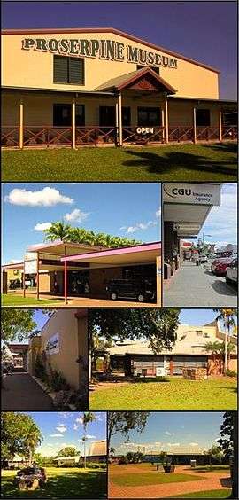 Top: Proserpine Museum, Upper left: Proserpine Entertainment Centre, Upper right: Main St, Lower left: Whitsunday Regional Council Offices, Lower right: Proserpine Library, Bottom left: Ken MacPherson Memorial Gardens, Bottom right: Pioneer Park | |||||||
 Proserpine | |||||||
| Coordinates | 20°24′6″S 148°34′53″E / 20.40167°S 148.58139°ECoordinates: 20°24′6″S 148°34′53″E / 20.40167°S 148.58139°E | ||||||
| Population | 3,390 (2011 census)[1] | ||||||
| Established | 1890s | ||||||
| Postcode(s) | 4800 | ||||||
| Elevation | 20 m (66 ft)[2] | ||||||
| Time zone | AEST (UTC+10) | ||||||
| Location | |||||||
| LGA(s) | Whitsunday Regional Council | ||||||
| State electorate(s) | Whitsunday | ||||||
| Federal Division(s) | Dawson | ||||||
| |||||||
Proserpine (/ˈprɒsərpaɪn/, locally [ˈpɹɔsəpɑen][3]) is a town in Whitsunday Region in the state of Queensland, Australia.[4] It is situated on the Bruce Highway. It was founded in the 1890s. In the 2011 census, Proserpine had a population of 3,390. Proserpine is an anchor for the Whitsundays region, providing some key infrastructure, including the rail station, the mainland airport for scheduled jet services, two high schools, the hospital and other vital services. It lies around 26 kilometres (16 mi) inland from Airlie Beach on the Bruce Highway, and it has grown since its foundation in the 19th century due to the success of its sugar and cattle industries. The demonym of Proserpine is Proserpinian.
The town is located along the banks of the Proserpine River and is surrounded by vast flat areas of land primarily used for cane farming. It prides itself on its friendly atmosphere and in 2007 it won the Tourism Queensland Friendliest town award.[5] Proserpine is experiencing a resurgence in economic growth fueled by its Airport gaining International services in 2016, its affordability and a renewed appreciation of its short distance to the traditional tourist areas of the region whilst having many important medical, educational and transportation facilities that are desired by the people of today that are unavailable in those tourist areas.
Name
The town name Proserpine derives from the Proserpine River, whose name was derived from the legend of the Greek goddess Persephone (whose Latin name is Proserpine).[4] It is sometimes nicknamed "ProsVegas" (although there are no casinos in the town) or abbreviated to "Prossy" by locals. Recently it is argued that the name was taken form one of the original cattle stations in the area.
History

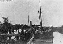
The town was founded around 1890 just after the sugar mill was constructed. The Postal Office opened in 1886. The town experienced high growth in the 1900s as the local sugar industry grew and exported raw sugar via the Proserpine Landing from here it was sent to refineries. At this time it was the fastest growing regional town in Queensland. By about the 1940s with the onset of World War 2 the towns growth started to slow.
In the 1950s the Proserpine Airport was opened which increased the towns accessibility by air. In the 1960s raw sugar exports from the landing ceased and were diverted to Mackay which further hampered the towns economic prospects. Also during this period the coastal communities of Airlie Beach and Cannonvale began to take shape which reduced the attractiveness of the town as a place to live but both communities were devastated by Cyclone Ada in January 1970 and Proserpine was left basically unaffected owing to its inland position. In 1986 construction commenced on the Peter Faust Dam 25 kilometres (16 mi) NW of the town to be used for flood mitigation during the wet season and irrigation during the dry, the dam was completed in 1990 and was expected to take decades to fill but a passing cyclone helped boost levels close to maximum capacity. A new housing estate known as "John's Estate" was constructed in the south eastern part of town sometime during this decade. The 1990s saw the Proserpine Sugar Mill crush a record amount of cane in 1996.
The 2000s brought renewed growth especially in the industrial & logistic sectors with new warehouses and small businesses constructed during this time. Growth of the town really started to pick up in 2006 with the announcement of the construction of a new housing subdivision in Renwick Road. Sales were strong and construction began in mid 2007. As of 2015 most of the estate is entirely built out.
Heritage listings
Proserpine has a number of heritage-listed sites, including:
- Herbert Street: Proserpine Hospital[6]
- Main Street: St Paul's Anglican Church[7]
Demographics
In the 2011 census, Proserpine recorded a population of 3,390 people; 49.5% male and 50.5% female. The median age of the Proserpine population was 39 years, 2 years above the national median of 37. The country of birth of people living in Proserpine was 2.4% England, 0.6% Philippines, 0.5% South Africa, 0.4% Italy, 2.1% New Zealand. 92.5% of people spoke only English at home; the next most common languages were 0.4% Tagalog, 0.2% German, 0.2% French, 0.6% Italian, 0.1% Spanish. The religious make up of Proserpine was 22.9% Anglican, 3.7% Presbyterian and Reformed, 12.6% Uniting Church, 17.1% No Religion, 25.5% Catholic. 46.6% of people were married, 31.2% never married and 9.7% were separated or divorced. There were 227 widowed people living in Proserpine. The median individual income was $520.00 per week and the median household income was $929 per week, compared to the national median of $1,234. 29.6% of residences were fully owned, and 28.1% were in the process of being purchased by home loan mortgage. 38.4% of homes were rented. The median rent in Proserpine was $230 per week and the median mortgage repayment was $1517 per month.[8]
The historical population of Proserpine is as follows: 1901: 136, 1911: 1102, 1933: 2177, 1961: 2753, 1981: 3058, 2001: 3250, 2006: 3316, 2011: 3390,[9] 2016: 3900
Economy

Service and administration
Proserpine is an anchor and the main service and administration centre for the region. It provides key infrastructure including the rail station, mainland airport, 2 high schools (1 public, 1 catholic), the hospital and other vital services. Whitsunday Regional Council also has its main offices in Proserpine.
Industrial & Manufacturing
There are numerous businesses that specialize in light manufacturing of goods.
Logistical
Due to the towns location along the important arterial road the Bruce Highway the town hosts some transportation depots which are critical in the effective distribution of a variety of goods across the region.
Retail
The town has one small shopping centre known as "Freshfields Plaza" whose major tenant is Woolworths, it also has a few specialty stores including a liquor store and newsagency.
Many of the towns retail stores, professional offices are clustered in the Main Street area, however many of the stores are now vacant following economic downturn with the closure of the nearby mining industry. A Subway restaurant was completed in early June 2015 and is now operational. Many of the stores still open are town industry related.
Sugar
One of the town's main industries is sugar growing. In the NW corner of the Central Business District is a large factory known as the Proserpine Mill. It was established in 1897[10] and is one of the town's biggest employers at the present time. It is now recognized as one of the most modern sugar mills in the world.[11]
Tourism
Proserpine is approximately 15 minutes drive to Airlie Beach. While largely missing out on the benefits of tourism the town has seen interest of late from backpackers who wish to make the town a base for their stay on the Whitsunday mainland, some even travel to nearby Bowen to do fruit picking/packing. Proserpine is in relatively close proximity to notable attractions such as the Great Barrier Reef and the Whitsunday Islands. The town has a number of motels located strategically fronting the Bruce Highway.
Gold
Dittmer is the location of the largest gold find in the Whitsundays; it is 20 kilometres (12 mi) to the SW of Proserpine. The Dittmer Gold Mine has been closed since the 1960s.
Geography
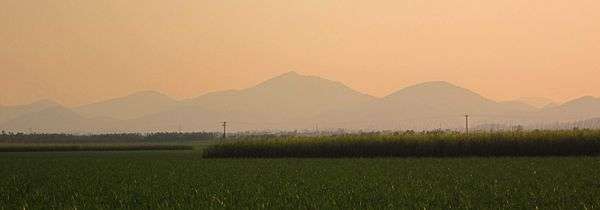
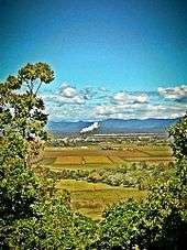
The land around Proserpine is relatively flat. Some of the land is flood prone during the wet season but most of the land is less flood-prone then it used to be prior to the construction of the Peter Faust Dam. Clarke Range is located to the west, northwards is Dryander National Park and to the east is Conway National Park.
The Clarke Range to the west of the town contains the small, former gold mining town of Dittmer and provide a dramatic backdrop to the area.
Landmarks and attractions

Landmarks
• Proserpine Mill chimneys. Twin chimneys that are 62m tall (equivalent to 18 stories) and dominate the skyline.
• Proserpine water tower and associated mural.
Attractions
• Art Deco façades in Main St. A lot of the shops in Main St have art deco façades. Most are in disrepair and require restoration.
• Proserpine Historical Museum – A museum run by local volunteers located on the Bruce Highway.
• Proserpine Entertainment Centre – A relatively young building used for various events/functions including movies, funerals, matinées, and concert dances.
• Peter Faust Dam located 22 kilometres (14 mi) west of Proserpine is a dam popular with fisherman and watersports enthusiasts.
Events

The PBR (Professional Bull Riders) event is held every year in September (dates vary) at the Proserpine Showgrounds. Attendance numbers usually range from 2,000–3,000. In 2008 an estimated 2,132 people attended. The Proserpine Show is held at the Proserpine Showground around 24–25 June. It is a typical show with carnival rides, sideshow alley and fireworks. The Harvest Festival is generally held in October, around the 20th of the month, as a celebration of the end of sugar crushing at the mill. It includes carnival rides at Les Stagg Oval and a parade with floats through the Main Street. In recent years the festival has not run due to a lack of volunteers. The Proserpine Rotary Christmas Fair is an annual event held on 18 December. Main Street is closed off and stall holders take the place of cars. Most shops open or stay open until late and take advantage of the increased business by offering discounts, special deals.[12] In past years general festivals/fairs have been held usually in Main Street. In recent years the frequency of such events has been decreasing but there is a desire amongst the community for a revival.
Sports and facilities
Les Stagg Oval is located on the western side of the railway tracks and the Whitsunday Brahmans are based there. There is also a BMX track, skate park and half court basketball courts located in the vicinity of the oval. Proserpine Junior/Senior Sporting Complex is a medium-sized facility located on the western edge of town at the intersection of Crystalbrook and Kelsey Creek Road. Sports that it caters for are junior/senior cricket, soccer and football. Night games can be played at the eastern end of the facility. The Proserpine Showground is located in the south-western corner of the town and is used for various events such as auctions, swap meats, car boot sales, softball but the main event that attracts the largest amount of attendees is the Proserpine Show which is held on 24 and 25 June. In 2012, the Proserpine show celebrated 100years at the showground.[13]
Education and health


Proserpine has two local public schools: Proserpine State Primary School and Proserpine State High School. There is also a private Catholic school, Saint Catherine's. Saint Catherine's recently opened a secondary campus on Renwick Road to cater for growth in its enrolment numbers. It is a modern campus with all necessary facilities.[14][15] The two public schools recently finished building multi-purpose halls and a new language center at Proserpine State High for the study of Asian languages as part of the Federal Governments "Building the Education revolution" program. On June 8, 2013, Proserpine State High School celebrated its centenary. It has been at its present site in Sterry Street since 1963 and was previously located where the Entertainment Centre stands today.
The Proserpine Hospital in Taylor St is the main hospital for the Whitsunday Region and is a modern facility which provides many services among them are CT (X-ray computed tomography), Obstetrics, Pediatrics, Ear Nose and Throat (ENT) and Antenatal. It has a 24hour Emergency Department. It also features a Helipad on the opposite side of Taylor street which is used for more serious emergencies.[16] It is nearing capacity as the towns population and region as a whole grows. The local community centre had to relocate from the hospital to a temporary site to facilitate the expansion of hospital services. A brand new community centre is expected to start construction soon in the eastern part of town. It is anticipated that a larger facility will have to be built sometime in the next decade as the current site is limited in expansion opportunities.
Telecommunications
Internet services are adequate in the town with access to ADSL2+ speeds. NBN towers have been built around the town to provide NBN services to customers in the semi-rural outlying areas. Construction of the NBN Fibre network will begin Q1 2016 with completion Q4.
Transport
Bus
There are Whitsunday Transit bus services to and from Airlie Beach and a connection service to Proserpine / Whitsunday Coast Airport. The main bus stations are located in Mill Street (in front of Mill Street Park) and Blair Street (outside of the BP Service station).
Taxi
Taxi services operate 24/7 in the town and a taxi rank is located outside the courthouse.
Air

Proserpine Airport has flights to Sydney, Brisbane, Melbourne as of December 2015. The airport opened in 1951 and the first flight landed at it on 3 November the same year. It was a flight from Brisbane in a Douglas DC-3.
The terminal recently underwent an upgrade in 2010/11 and the newly upgraded terminal was officially opened on 20 December 2011. This upgrade provided an expanded parking area with the introduction of paid parking, new luggage carousel, more check-in counters and an overall new look. The local council announced in early 2013 that it was considering entering a partnership with a private company to further expand the terminal to triple its present size. Access to the airport is via the Bruce Highway and Sir Reginald Ansett Drive by either private vehicle, or by bus.
In 2016 the Airport will gain International status, with the first flights expected to be to Auckland, the largest city of New Zealand followed by flights to Mainland China.
Rail
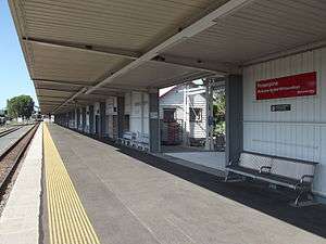
Proserpine is located on the North Coast line and has services between Brisbane and Cairns provided by the Spirit of Queensland which depart from Proserpine Station located in Hinschen Street almost at the geographical centre of the town. It was opened on 2 July 1910 and Governor William MacGregor was in attendance having arrived on a special train, the opening was timed to coincide with the Proserpine Show. Regular services to Bowen commenced on 18 July 1910 (was later connected to Mackay and subsequently Brisbane). The station is fairly long and is also used for freight. It has restroom facilities, covered waiting areas, arrival and departure announcements and coaches that provide connections to surrounding areas meet every arriving train.
Government
Proserpine is locally governed by Whitsunday Regional Council, a product of amalgamation of the former Shire of Whitsunday with the former Shire of Bowen. The mayor is Jennifer Whitney. Jason Costigan is the member for the state seat of Whitsunday and George Christensen is the federal member for Dawson. Voting in elections is usually conducted at the Magistrates Court. Proserpine is division 2 in the Whitsunday Regional Council area and the current councillor representing division 2 is John Collins.
Media
Proserpine is served by several radio stations including the Hot FM and Sea FM networks, MY105 FM Hot Country and Legends, 4MK AM, Zinc FM and the ABC's local Tropical North station. The town receives broadcasts from five television networks – Seven Queensland, WIN (an affiliate of the Nine Network), Southern Cross Ten, ABC TV and SBS One. All networks also provide additional digital only television stations. Of the three main commercial networks, Seven Queensland and WIN produce 30-minute local news bulletins each weeknight (both produced from local newsrooms, but broadcast from studios elsewhere in the state – Maroochydore and Toowoomba respectively) with WIN also producing a statewide late news bulletin for regional Queensland. Southern Cross Ten also provides short local news updates throughout the day. The towns local paper is the Whitsunday Coast Guardian (historically and still known by locals as the Proserpine Guardian) which used to be printed in the Guardian building on Chapman St but is now printed in Townsville. The Whitsunday Times also serves the town but is more oriented towards the coastal communities of the region but does occasionally cover Proserpine news.
Crime
Proserpine has an average/below average crime rate for a town of its size. The most common crimes committed are drink driving, minor property theft, vandalism and hooning. Most minor crime is in relation to juvenile offenders. The police station is located in Mill Street and the Proserpine Magistrates Court is located adjacent on the intersection of Mill and Main Streets. The local police station is well respected within the town and known for its community policing approach.
Notable people from Proserpine
- Sidney Cotton Australian inventor, photographer and aviation and photography pioneer.
- Sam Faust Australian professional rugby league player.
- Andrew Fraser Queensland State Politician.
- Max Grosskreutz Australian speedway rider.
- Travis Waddell Australian professional rugby league footballer, plays for Newcastle Knights
Climate

Proserpine's climate consists of two main seasons. The "Wet Season" (November to April) and The "dry season" (May to November). The wet season is usually relatively humid with high rainfall in most years and the dry season is cool and pleasant with scarce rainfall and low humidity. The peak season for tourism is during the winter months owing to the reliable extended runs of clear weather which are ideal for outdoor activities.
The town has a humid subtropical climate (CWa) under the Köppen climate classification. During winter temperatures in outlying areas sometimes dip below zero but rarely in Proserpine itself due to the Urban heat island effect. The same occurs with Fog as it is usually denser in locations out of town. The highest rainfall in the region occurs to the north east of the town in the Conway National Park with places such as Preston receiving more rainfall than Proserpine. The localities of Midge Point, Hideaway Bay, Crystalbrook, Kelsey Creek are usually the driest in the region owing to influences such as distance from the ocean and rain shadows.
The area has been affected by tropical cyclones most significantly Cyclone Ada in January 1970 and Cyclone Ului in March 2010. It was also affected (but to a lesser extent than southern and western areas) by the 2009 Australian dust storm.
A cyclone shelter was completed in February 2013 at Proserpine State Primary School and was a joint project between the Queensland Government and the Government of the Emirate of Abu Dhabi the latter committing $30million AUD towards the cyclone shelter program for which the community is very thankful. At more than 1,500 square metres, they can provide shelter for up to 800 people and are equipped with features to ensure people’s comfort and safety, such as a backup generator, a kitchen, 10 toilets and five showers. Mr Faisal Saif Almazrouei, Third Secretary at the Embassy of the United Arab Emirates (UAE) attended the official opening of the Proserpine Shelter on March 26, 2013.
| Climate data for Proserpine Airport | |||||||||||||
|---|---|---|---|---|---|---|---|---|---|---|---|---|---|
| Month | Jan | Feb | Mar | Apr | May | Jun | Jul | Aug | Sep | Oct | Nov | Dec | Year |
| Record high °C (°F) | 41.2 (106.2) |
40.4 (104.7) |
37.9 (100.2) |
34.0 (93.2) |
32.0 (89.6) |
32.0 (89.6) |
32.7 (90.9) |
34.1 (93.4) |
36.3 (97.3) |
39.0 (102.2) |
41.2 (106.2) |
42.9 (109.2) |
42.9 (109.2) |
| Average high °C (°F) | 31.4 (88.5) |
31.1 (88) |
30.2 (86.4) |
28.7 (83.7) |
26.5 (79.7) |
24.5 (76.1) |
24.3 (75.7) |
25.6 (78.1) |
28.4 (83.1) |
30.2 (86.4) |
31.4 (88.5) |
32.0 (89.6) |
28.7 (83.7) |
| Average low °C (°F) | 22.6 (72.7) |
22.9 (73.2) |
21.5 (70.7) |
19.1 (66.4) |
15.8 (60.4) |
12.7 (54.9) |
11.0 (51.8) |
11.7 (53.1) |
14.4 (57.9) |
17.5 (63.5) |
19.9 (67.8) |
21.8 (71.2) |
17.6 (63.7) |
| Record low °C (°F) | 15.9 (60.6) |
15.0 (59) |
14.2 (57.6) |
7.6 (45.7) |
5.0 (41) |
0.5 (32.9) |
−0.9 (30.4) |
0.0 (32) |
3.8 (38.8) |
7.4 (45.3) |
13.0 (55.4) |
14.3 (57.7) |
−0.9 (30.4) |
| Average precipitation mm (inches) | 290.1 (11.421) |
381.9 (15.035) |
209.0 (8.228) |
118.3 (4.657) |
70.4 (2.772) |
38.1 (1.5) |
23.7 (0.933) |
25.9 (1.02) |
18.9 (0.744) |
36.2 (1.425) |
88.7 (3.492) |
165.8 (6.528) |
1,473.5 (58.012) |
| Source: [17] | |||||||||||||
See also
References
- ↑ "QuickStats: Proserpine". 2011 Census. Australian Bureau of Meteorology. 21 June 2012. Retrieved 24 July 2012.
- ↑ Bureau of Meteorology Retrieved 2007-11-22.
- ↑ Macquarie Dictionary, Fourth Edition (2005). Melbourne, The Macquarie Library Pty Ltd. ISBN 1-876429-14-3
- 1 2 "Proserpine (entry 27547)". Queensland Place Names. Queensland Government. Retrieved 13 March 2014.
- ↑ "2007 State Winners". Keep Australia Beautiful Queensland. Retrieved 17 August 2012.
- ↑ "Proserpine Hospital (entry 601573)". Queensland Heritage Register. Queensland Heritage Council. Retrieved 16 July 2013.
- ↑ "St Paul's Anglican Church (entry 601589)". Queensland Heritage Register. Queensland Heritage Council. Retrieved 1 August 2014.
- ↑ "Proserpine Local Stats". Retrieved 24 July 2012.
- ↑ "Queensland Places Proserpine". Retrieved 24 July 2012.
- ↑ "Proserpine Sugar Mill". 2006 Proserpine Co-operative Sugar Milling Association Limited. Retrieved 18 March 2012.
- ↑ "Guide to Proserpine in QLD". Sydney Morning Herald. Retrieved 24 July 2012.
- ↑ "Proserpine Rotary Christmas Fair". 'Travel Oz Info' – Travel Information for Australia. Retrieved 18 March 2012.
- ↑ "Show Whitsunday". 2010 Proserpine A.P. & I. Inc. Retrieved 18 March 2012.
- ↑ New Catholic school approved. Whitsunday Times. APN News & Media. Retrieved 31 January 2012.
- ↑ (17 February 2011). St Catherine's School, Proserpine (Yr 5–7). Catholic Education Office Diocese of Townsville. Retrieved 31 January 2012.
- ↑ "Whitsunday Health service Proserpine Hospital Campus Profile". Retrieved 17 August 2012.
- ↑ "PROSERPINE AIRPORT". Climate statistics for Australian locations. Bureau of Meteorology. January 2014. Retrieved 29 January 2014.
External links
| Wikimedia Commons has media related to Proserpine, Queensland. |