Prince William Forest Park
| Prince William Forest Park | |
|---|---|
|
IUCN category III (natural monument or feature) | |
|
Quantico Creek in Prince William Forest Park | |
  | |
| Location | Prince William County, Virginia, United States |
| Nearest city | Dumfries, VA |
| Coordinates | 38°35′07″N 77°22′47″W / 38.58528°N 77.37972°WCoordinates: 38°35′07″N 77°22′47″W / 38.58528°N 77.37972°W |
| Area | 16,084 acres (6,509 ha) |
| Established | November 14, 1936 |
| Visitors | 379,535[1] (in 2011) |
| Governing body | National Park Service |
| Website | Prince William Forest Park |


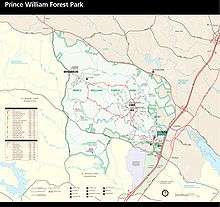
Prince William Forest Park was established as Chopawamsic Recreational Demonstration Area in 1936 and is located in southeastern Prince William County, Virginia,[2] adjacent to the Marine Corps Base Quantico. The park is the largest protected natural area in the Washington, D.C. metropolitan region at over 16,000 acres (6,500 ha). Today, the park is a window into the past and serves as an example of what much of the East Coast once looked like centuries ago.
The park serves as the largest example of Eastern Piedmont forest in the National Park System (arguably, one of the most heavily altered ecosystems in North America). The park also protects the Quantico Creek watershed. It is a sanctuary for numerous native plant and animal species.
Recreational opportunities
A variety of recreational opportunities are available, which include:
- Wildlife viewing
- 37 miles (60 km) of hiking trails. Most of these trails either go to a historical/cultural destination such as Pyrite Mine or follow Quantico Creek with views of its small waterfalls.
- 21 miles (34 km) of bicycle accessible roads and trails.
- Several tent camping options, including family, group and backcountry camping are available as well as rustic cabin camping, and a full-service, concessionaire-operated RV campground, are available.
Cultural resources
The park’s cultural resources are also varied. They include:
- The remnants of Joplin, Hickory Ridge, and Batestown, three small communities existing prior to the park’s establishment
- The reclaimed remnants of the Cabin Branch Pyrite Mine along Quantico Creek
- The reclaimed remnants of the Greenwood gold mine[3]
- Products of the Civilian Conservation Corps (CCC), which built the facilities, roads and lakes from 1936 to 1942.[2]
- The U.S. Army’s Office of Strategic Services (OSS) which used the land exclusively for training spies and radio operators between 1942 and 1945
Known wildlife
Tortoises such as the Eastern box turtle can be found in Prince William Forest Park, especially after a light rain. There are a number of Amphibians that inhabit the park. Toads and frogs, such as the American toad, American bullfrogs, and Cope's gray tree frog can be spotted in the park, as can salamanders such as the marbled salamander and the eastern red-backed salamander. A variety of bird species, such as the hooded warbler, the wood thrush, and the red-shouldered hawk, can also be found. The park is also home to Mammals, such as red foxes and white-tailed deer; spotted along the upper North Valley Trail. A few black rat snakes have been seen in and around logs and brush areas. Various skinks can be seen around sunny areas of the trails.
History
The park was developed by Works Progress Administration workers after the Great Depression. Landscaping and structures were designed by National Park Service architects. Four camp areas are listed individually on the National Register of Historic Places:[4]
- Goodwill Historic District, Chopawamsic RDA Camp 1
- Mawavi Historic District, Chopawamsic RDA Camp 2
- Orenda/SP-26 Historic District, Chopawamsic RDA Camp 3
- Pleasant Historic District, Chopawamsic RDA Camp 4
The park also includes the Cabin Branch Pyrite Mine Historic District, listed on the National Register of Historic Places in 2002.[4] The park itself was designed as the Prince William Forest Park Historic District in 2012.[5]
See also
| Wikimedia Commons has media related to Prince William Forest Park. |
References
- ↑ "NPS Stats". National Park Service. Retrieved September 27, 2012.
- 1 2 National Park Service - Chopawamsic Recreational Demonstration Area
- ↑ Jeff Wynn, "A Ground Electromagnetic Survey Used to Map Sulfides and Acid Sulfate Ground Waters at the Abandoned Cabin Branch Mine, Prince William Forest Park, Northern Virginia Gold-Pyrite Belt," U.S. Geological Survey, Reston, VA 20192, retrieved April 7, 2006
- 1 2 National Park Service (2010-07-09). "National Register Information System". National Register of Historic Places. National Park Service.
- ↑ "National Register of Historic Places Listings". Weekly List of Actions Taken on Properties: 4/02/12 through 4/06/12. National Park Service. 2012-04-13.
External links
- National Park Service: Official Prince William Forest Park website
- Friends of Prince William Forest Park
- Prince William Forest Park, National Park Service at Google Cultural Institute
- Chopawamsic Recreational Demonstration Area - Cabin Camp 1, Prince William Forest Park, Triangle, Prince William County, VA — from the HABS—Historic American Buildings Survey at the Library of Congress.
- Chopawamsic Recreational Demonstration Area - Cabin Camp 1, Dining Hall, Prince William Forest Park, Triangle, Prince William County, VA — from HABS—Historic American Buildings Survey, LOC.