Prettau
| Prettau | |
|---|---|
| Comune | |
| Gemeinde Prettau Comune di Predoi | |
|
Prettau | |
 Prettau Location of Prettau in Italy | |
| Coordinates: 47°2′N 12°6′E / 47.033°N 12.100°ECoordinates: 47°2′N 12°6′E / 47.033°N 12.100°E | |
| Country | Italy |
| Region | Trentino-Alto Adige/Südtirol |
| Province / Metropolitan city | South Tyrol (BZ) |
| Government | |
| • Mayor | Robert Alexander Steger |
| Area | |
| • Total | 86.7 km2 (33.5 sq mi) |
| Elevation | 1,475 m (4,839 ft) |
| Population (Nov. 2010) | |
| • Total | 597 |
| • Density | 6.9/km2 (18/sq mi) |
| Demonym(s) |
German: Prettauer Italian: di Predoi |
| Time zone | CET (UTC+1) |
| • Summer (DST) | CEST (UTC+2) |
| Postal code | 39030 |
| Dialing code | 0474 |
| Website | Official website |

Prettau (German pronunciation: [prɛˈtaʊ̯]; Italian: Predoi [preˈdɔi]) is a comune (municipality) in South Tyrol, a province in northern Italy, located about 80 kilometres (50 mi) northeast of Bolzano, on the border with Austria.
Geography
As of 30 November 2010, it had a population of 597 and an area of 86.7 square kilometres (33.5 sq mi).[1] It is the northernmost comune of Italy.
Prettau borders the following municipalities: Brandberg (Austria), Sand in Taufers, Krimml (Austria), Prägraten am Großvenediger (Austria), Sankt Jakob in Defereggen (Austria), and Ahrntal.
Society
Linguistic distribution
According to the 2011 census, 97.33% of the population speak German and 2.67% Italian as first language.[2]
Demographic evolution

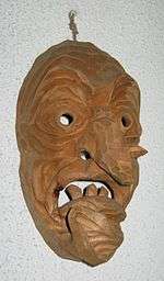
A typical carved wooden mask from Prettau
Bibliography
- Stefan Steinhauser, Eduard Tasser: Prettau – Bilder, Fakten, Geschichten. Prettau 2008 Download (25 MB)
References
- ↑ All demographics and other statistics: Italian statistical institute Istat.
- ↑ "Volkszählung 2011/Censimento della popolazione 2011". astat info. Provincial Statistics Institute of the Autonomous Province of South Tyrol (38): 6–7. June 2012. Retrieved 2012-06-14.
External links
![]() Media related to Prettau at Wikimedia Commons
Media related to Prettau at Wikimedia Commons
- (German) (Italian) Homepage of the municipality
This article is issued from Wikipedia - version of the 4/29/2016. The text is available under the Creative Commons Attribution/Share Alike but additional terms may apply for the media files.