Prakasam district
| Prakasam district ప్రకాశం జిల్లా | |
|---|---|
| District of Andhra Pradesh | |
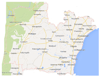
 Location of Prakasam district in Andhra Pradesh | |
| Country | India |
| State | Andhra Pradesh |
| Administrative division | Prakasam district |
| Headquarters | Ongole |
| Tehsils | 56[1] |
| Government | |
| • Lok Sabha constituencies | Bapatla (SC) (Lok Sabha constituency), Ongole (Lok Sabha constituency) |
| • Assembly seats | 12 |
| Area | |
| • Total | 17,626 km2 (6,805 sq mi) |
| Population (2011) | |
| • Total | 3,397,448[2] |
| • Urban | 19.52% |
| Demographics | |
| • Literacy | 63.53% |
| • Sex ratio | 981 |
| Vehicle registration | AP-09 |
| Major highways | NH-5 |
| Coordinates | 15°20′N 79°33′E / 15.333°N 79.550°ECoordinates: 15°20′N 79°33′E / 15.333°N 79.550°E |
| Website | [Prakasam district website Official website] |

Prakasam district is an administrative district in the Coastal Andhra region of the Indian state of Andhra Pradesh. The headquarters of the district are located at Ongole. It is located on the west coast of Bay of Bengal and is bounded by Guntur district on the north, Kurnool district on the west, Kadapa and Nellore districts on the south. A part of north west region also borders the Mahabubnagar district of Telangana.[3] It is the 3rd largest district in the state with an area of 17,626 km2 (6,805 sq mi) and had a population of 3,392,764 as per 2011 census of India.[4]
Etymology
The district was named after the patriot and first Chief Minister of Andhra State Tanguturi Prakasam, also known as Andhra Kesari (Lion of Andhra), who was born in the village of Vinodarayunipalem. It was accordingly renamed as Prakasam District in the year 1972.[5]
History
Prakasam district was originally constituted on 2 February 1970, carved out of Guntur, Nellore and Kurnool districts of Andhra Pradesh.[6] It was carved out of three taluks of Guntur District, i.e. Addanki, Chirala, and Ongole, four taluks of Nellore district, i.e. Kandukur, Kanigiri, Darsi and Podili and three taluks of Kurnool district i.e. Markapur, Yarragondapalem and Giddaluru. It is one of the nine districts in the Coastal Andhra region of Andhra Pradesh.
Prakasam District is a part of the Red Corridor.
Geography
Prakasam district occupies an area of 17,626 square kilometres (6,805 sq mi),[4] comparatively equivalent to Indonesia's Seram Island.[7]
The only Municipal Corporation in Prakasam is Ongole. Some of the main towns in Prakasam district are Singarayakonda, Addanki, Inkollu, Markapur, Yerragondapalem, Podili, Darsi, Donakonda, Chirala, Kandukur, Pamuru, Parchur, Giddaluru, Dornala, Cumbum, Kanigiri, Chimakurthy and Martur. Markapur is India's main slate manufacturing town where the historic temple of Lord Chennakesava is situated. Chimakurthi is world-renowned for its granite reserves. Dornala is also known as Diguva Srisailam, since it is very near the historic pilgrimage centre of Srisailam.
Cumbum lake also known as Gundalakamma lake built on Gundalakamma rivulet upon Nallamalai hills is one of the oldest man made lakes of Asia. The anicut was built by the Vijayanagar princess Varadharaj Amma. The lake in its present form is about 7 km long and on average, about 3.5 km wide As per the Imperial gazette of India at the turn of the 20th century the height of the dam was 57 feet (17 m) and the drainage area was 430 square miles (1,100 km2). The direct irrigation land was about 10,300 acres (42 km2) in all.[3] Cumbum lake is accessible both by the rail Guntur-Nandyal railway line and by road 108 km from Ongole.
Demographics
At the 2011 census Prakasam District had a population of 3,392,764,[8] roughly equal to the nation of Panama[9] or the US state of Connecticut.[10] It was the 98th most populous district in India (out of a total of 640).[8] The district had a population density of 192 inhabitants per square kilometre (500/sq mi).[8] Its population growth rate over the decade 2001–2011 was 10.9%.[8] Prakasam had a sex ratio of 981 females for every 1000 males,[8] and a literacy rate of 63.53%.[8]
Telugu is the language of the land. Cumbum mandal showed a very good growth indicators in the 2011 census. According to census of India, Cumbum mandal has been recognised as the second highest in literacy in Praksam district literacy having 73.55% literates after Ongole Mandal. Also Cumbum mandal is the third highest in sex ratio in Prakasam district having 1031 female population per 1000 males.
Household indicators
In 2007–2008 the International Institute for Population Sciences interviewed 977 households in 42 villages across the district.[11] They found that 91.1% had access to electricity, 91.3% had drinking water, 40% toilet facilities, and 54.6% lived in a pucca (permanent) home.[11] 31.7% of girls wed before the legal age of 18[12] and 73.9% of interviewees carried a BPL card.[11]
Economy
Industries
The district has many service industries like Industrial testing, Electrical Appliance repair, Clinical Laboratory, Servicing of Computers Hardware, Tourism, Hospitality industry etc. Major exports from the district include Sea food, processed tobacco, granite blocks, granite monuments and yarn.[13]
There are many industries of food and agro, mineral, chemical, leather, plastic and rubber, engineering, cotton and textiles, electronic products. All these industries deals with Prawn/Fish Processing and Canning, Dairy Products, Granite industries, Drugs and Pharmaceuticals, Tanning, Fishing Nets, Surgical Cotton etc. Forest based industries produce Ayurvedic Medicines, Essential Oil (Palm Rose Oil), Wooden Furniture, Wooden Toys, Bamboo Products etc.[14]
Minerals
Prakasam is one of the leading district in granite mining in the State with discovery of “Galaxy Granite” in the Chimakurthy area of the district. Good deposits of coloured granites are located occur around Uppumangaluru and Kodidena.[14]
The minerals found in the district are Baryte, iron ore, quartz, and silica sand. In 2010-11, 4,300 tonnes of Baryte, 22,722 tonnes of quartz, 2,24,075 tonnes of silica sand and 400 tonnes of iron ore were produced.[14]
Marine Resources
Brackish water prawn culture in the coastal mandals of Chirala, Ongole, Singarayakonda, Gudlur etc. provides Sea food processing. Salt production in the extent of 4,000 acres (1,600 ha) of Govt. and private lands which has a scope for manufacturing of iodized salt.
Tourism
The district is having coastal line of nearly 100 km (62 mi). The state tourism department (APTDC) has proposed resorts and development of beaches at the places like Ramayapatnam, Pakala, Kothapatnam, and Odarevu.[5]
Ongole Cattle
Ongole cattle or Ongole Gittalu are indigenous to the Andhra region in the Prakasam District in the State of Andhra Pradesh in India. The breed derives its name from the place name, Ongole. Some also refer to this breed as Nelore cattle as this area was once part of the Nellore area. The bull, Bos Indicus, is in great demand as it is said to possess resistance to both foot and mouth disease and mad cow disease.These cattle are commonly used in bull fights in Mexico and some parts of East Africa due to their strength and aggressiveness.
Tourism
Bhairava Kona Caves


The Bhairava Kona cave temples are 7th century single stone rock-cut cave temples (similar to Mahabalipuram) for Lord Shiva.[15][16][17]
Transport
Roadways
The district is well connected by National highways, state highways and district roads as well. The NH 5 or NH 16 passes through Ongole which is the major highway connecting Howrah - Chennai, a part of Asian Highway Network. APSRTC, a state government public bus transport operates services connecting major cities and towns like Kandukur, Chirala, Markapur, Ongole and also to remote villages in the district.
Railways
Railways in the district comes under South Central Railway zone and has good connectivity on Howrah-Chennai main line. Ongole is one of the main stations of this district and most of the stations are under Vijayawada Railway Division.[18]
Airports
Minister of State for Civil Aviation, has granted site clearance for setting up of a Greenfield Airport at Ongole.[19]
Administrative divisions

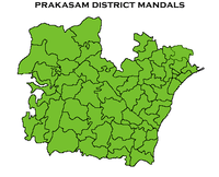
The district is divided into 3 revenue divisions, namely, Kandukur, Markapur and Ongole.[20] These are sub-divided into 56 mandals which consists of 1081 villages and 13 towns. These 13 towns (or urban settlements) in the district include, 1 municipal corporation, 3 municipalities and 4 nagar panchayats. Ongole is the only municipal corporation, Chirala, Kandukur, Markapur are the 3 municipalities and Addanki, Kanigiri, Chimakurthi, Giddalur are the nagar panchayats.[21] The 5 census towns in the district are Cumbum, Chirala (CT), Podili, Vetapalem, Pamur and Singarayakonda.[22]
Mandals
The list of 56 mandals in Prakasam district under 3 revenue divisions are listed in the following table:[22]
Notable personalities
There are many noted people from the district including Tanguturi Prakasam, a freedom fighter who was also the Chief Minister of Andhra State and Chief Minister of Madras Presidency. U. Aswathanarayana who was a Director of the Mahadevan International Centre for Water Resources Management in India. From the film industry personalities include Bhanumathi Ramakrishna was a film actress who was also a producer, director and singer. Johnny Lever, Indian film actor and one of the most popular comedians in Bollywood. D. Ramanaidu, film producer; Tottempudi Krishna, film director and editor; Giri Babu, film actor; Raghu Babu, film actor and comedian in Telugu cinema; Dharmavarapu Subramanyam, comedian in Telugu cinema. Pullela Gopichand, an all-england champion and national badminton coach.
Transport
The total of core road network of the district is 1,286.155 km (799.180 mi). It includes, 542.047 km (336.812 mi) of existing and a proposed length of 644.110 km (400.231 mi).[23]
Education
The primary and secondary school education is imparted by government, aided and private schools, under the School Education Department of the state.[24][25] As per the school information report for the academic year 2015-16, there are a total of 4,311 schools. They include, 33 government, 2,949 mandal and zilla parishads, 1 residential, 1079 private, 10 model, 37 Kasturba Gandhi Balika Vidyalaya (KGBV), 50 municipal and 152 other types of schools.[26] The total number of students enrolled in primary, upper primary and high schools of the district are 562,510.[27] The total number of students enrolled in primary, upper primary and high schools of the district are 461,065.[28]
References
- ↑ "District - Guntur". Andhra Pradesh Online Portal. Retrieved 23 August 2014.
- ↑ "West Godavari district profile". Andhra Pradesh State Portal.
- ↑ "Mandals in Prakasam district". AP State Portal. Retrieved 24 May 2014.
- 1 2 "Prakasam dist". AP state portal. Retrieved 16 June 2014.
- 1 2 "District info" (PDF). apind.gov.in. Retrieved 16 June 2014.
- ↑ Law, Gwillim (25 September 2011). "Districts of India". Statoids. Retrieved 11 October 2011.
- ↑ "Island Directory Tables: Islands by Land Area". United Nations Environment Program. 18 February 1998. Retrieved 11 October 2011.
Seram 17,454
- 1 2 3 4 5 6 "District Census 2011". Census2011.co.in. 2011. Retrieved 30 September 2011.
- ↑ US Directorate of Intelligence. "Country Comparison:Population". Retrieved 1 October 2011.
Panama, 3,460,462, July 2011 est.
- ↑ "2010 Resident Population Data". U. S. Census Bureau. Retrieved 30 September 2011.
Connecticut, 3,574,097
- 1 2 3 "District Level Household and Facility Survey (DLHS-3), 2007-08: India. Andhra Pradesh" (PDF). International Institute for Population Sciences and Ministry of Health and Family Welfare. 2010. Retrieved 3 October 2011.
- ↑ "How Do I? : Obtain Marriage Certificate". National Portal Content Management Team, National Informatics Centre. 2005. Archived from the original on 11 October 2011. Retrieved 3 October 2011.
To be eligible for marriage, the minimum age limit is 21 for males and 18 for females.
- ↑ "Brief Industrial Profile of Prakasam District" (PDF). Ministry of Micro, Small & Medium Enterprises, Government of India. Development Commissioner (MSME). Retrieved 16 June 2014.
- 1 2 3 "Geology and Mineral Resources of Prakasam District". Department of mines and geology, Andhra Pradesh. Retrieved 16 June 2014.
- ↑ "Temples of South India". google.com.sg.
- ↑ Staff Reporter. "Devotees throng rock cut cave temples at Bhairavakona". The Hindu.
- ↑ "List of rock-cut temples in India". chinabuddhismencyclopedia.com.
- ↑ "Vijayawada Division" (PDF). Indian Railways - South Central Zone. Retrieved 15 June 2014.
- ↑ "Site Clearance for Greenfield Airport at Ongole". Press Information Bureau. Ministry of Civil Aviation. Retrieved 16 June 2014.
- ↑ "Administrative Setup". Krishna District Official Website. Retrieved 20 November 2014.
- ↑ "Municipalities, Municipal Corporations and UDAs" (PDF). Directorate of Town and Country Planning. Government of Andhra Pradesh. Retrieved 28 June 2016.
- 1 2 "District Census Handbook – Prakasam" (PDF). Census of India. pp. 16–17, 48. Retrieved 18 January 2016.
- ↑ ":: APRDC ::". Andhra Pradesh Road Development Corporation. Roads and Buildings Department. Retrieved 9 November 2016.
- ↑ "School Education Department" (PDF). School Education Department, Government of Andhra Pradesh. Retrieved 7 November 2016.
- ↑ "The Department of School Education - Official AP State Government Portal". www.ap.gov.in. Retrieved 7 November 2016.
- ↑ "School Information Report". Commissionerate of School Education. Government of Andhra Pradesh. Retrieved 8 November 2016.
- ↑ "Student Information Report". Commissionerate of School Education. Child info 2015-16, District School Education - Andhra Pradesh. Retrieved 8 November 2016.
- ↑ "Student Information Report". Commissionerate of School Education. Child info 2015-16, District School Education - Andhra Pradesh. Retrieved 8 November 2016.
External links
| Wikimedia Commons has media related to Prakasam district. |
 |
Mahbubnagar district, Telangana | Guntur district | | |
| Kurnool district | |
Bay of Bengal | ||
| ||||
| | ||||
| Kadapa district | Nellore district |
| Topics |  | |
|---|---|---|
| Regions | ||
| Districts | ||
| Million-plus cities | ||
| Cities (population over 1 lakh) | ||
| Tourism |
| |
| Related lists |
| |
| ||