Prabalgad
Prabalgad Fort, also known as Muranjan and Pradhangad, is located between Matheran and Panvel in the Indian state of Maharashtra, at an elevation of 2300 feets in the Western Ghats. It was built on a plateau close to Matheran, but unlike Matheran it does not have a good source of water. It was known as Muranjan until it was taken over and renamed by the Maratha forces under Shivaji's rule.[1] The fort contains a temple to Ganesh and some stone ruins. Its sister fort is Irshalgad.[2] Right next to Prabalgad, to its north, lies the steep Kalavanti (also known as Kalavantin) Fort. Prabalgad is often confused with Kalavati, but they are two separate forts.
History
Prabalgad Fort in its present form, was built during Bahmani Sultanate to keep an eye on Panvel Fort and Kalyan Fort in North Konkan.[3] Around 1458 AD, Malik Ahmad, the prime minister of the kingdom of Ahmednagar, took over the fort during his conquest of Konkan.[4] After disintegration of Bahmani Sultanate, this fort remained with the Ahmadnagar Sultanate. During the collapse of the Ahmadnagar Sultanate, Shahaji tried helping them unsuccessfully against the separate forces of the Mughal Empire and the Adil Shahi dynasty and moved to Muranjan, along with wife Jijabai and younger son Shivaji for a brief period. However following Shahaji's defeat and agreement of Mahuli, North Konkan, along with this fort, was ceded to Mughals who granted ruling authority of the area to Adilshah of Bijapur.[5] The fort was conquered by Shivaji from the Mughals in 1657, after he establishing himself in the Kalyan-Bhivandi area.[6][7] At the time of the attack the fort was governed by Kesar Singh, a Mughal sardar, and was the only fort to put up a strong resistance. On seeing the signs of defeat the women in the fort performed Jauhar, a tradition of self-immolation to ensure an honorable and respectful death. Singh died during the battle in October 1657.[6][8] Singh's mother hid herself and her grandchild during the attack. Shivaji in an act of kindness made sure the lady and the child were allowed a safe passage out.[9][10]
In the year 1826 Umaji Naik, a freedom fighter, and his associates are believed to have made this as their home for a brief period of time.[2]
Geography
Prabalgad lies on the Prabal plateau between Matheran and Panvel and can be seen from the Mumbai-Pune Expressway. The Ulahas River runs to the east of the fort. The Gadhi River, and the Chanderi and Peb forts are to the west. To the south is the Patalganga River, and Manikgad and to the north is the Karnala fort.
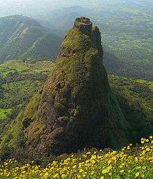
Kelve Teen (also known as Kalavati, Kalavantin or Kalavantinicha Sulka) is a 685m high pinnacle on the northern edge of the Prabal plateau. It is located near the Machi and Vajepur villages.[11] This is the site of the Kalavanti Fort.
References
- ↑ Kamal Shrikrishna Gokhale. Chhatrapati Sambhaji. Navakamal Publications.
- 1 2 Gunaji, Milind (2010). Offbeat Tracks in Maharashtra. Popular Prakashan. pp. 50–52. ISBN 9788179915783.
- ↑ "PRABALGAD KALAVANTIN HOTEL LODGING AND GUIDE SERVICE: KALAVATIN PRABALGAD HISTORY OF FORT".
- ↑ Radhey Shyam. The Kingdom of Ahmadnagar. Motilal Banarsidass Publisher. p. 28. ISBN 978-81-208-2651-9.
- ↑ The Quarterly Review of Historical Studies , Volumes 7-9. Institute of Historical Studies. 1968. p. 187.
- 1 2 Govind Sakharam Sardesai (1957). New History of the Marathas: Shivaji and his line (1600-1707). Phoenix Publications. p. 115.
- ↑ Nilkant Sadashiv Takakhav, Kr̥shṇarāva Arjuna Keḷūsakara (1985). Life of Shivaji, founder of the Maratha Empire , Volume 1. Sunita Publications. pp. 226–227.
- ↑ Murlidhar Balkrishna Deopujari. Shivaji and the Maratha art of war. Vidarbha Samshodhan Mandal. p. 61.
- ↑ V. B. Kulkarni (1963). Shivaji: The Portrait of a Patriot. Orient Longmans. p. 46.
- ↑ Ambika Sharma. "Prabalgad – Glory at its best".
- ↑ Harish Kapadia (1 March 2004). Trek the Sahyadris. Indus Publishing. pp. 57–58. ISBN 978-81-7387-151-1.
External links
- For high resolution image of Kalavantin durg see 250 MegaPixel image of Kalavantin.
- For a more pictures and a detailed review of How to Trek to Prabalgad Fort read this review: Prabalgad Fort Trek Review Blog on Hikeden you can also checkout the review of the Kalavantin durg here: Kalavantindurg (via Prabalmachi) Trek Review Blog.
Coordinates: 18°58′16″N 73°13′31″E / 18.971193°N 73.225293°E