Potrillo volcanic field
| Potrillo volcanic field | |
|---|---|
 Potrillo volcanic field viewed from the south, just west of Kilbourne hole, after light snow from winter storm Goliath | |
| Highest point | |
| Elevation | 5,561 ft (1,695 m) [1] |
| Prominence | 657 ft (200 m) [1] |
| Coordinates | 31°54′N 107°12′W / 31.900°N 107.200°WCoordinates: 31°54′N 107°12′W / 31.900°N 107.200°W [1] |
| Geography | |
| Location |
New Mexico, United States / Chihuahua, Mexico |
| Geology | |
| Age of rock | < 2.65 million year[1] |
| Mountain type | Volcanic field[1] |
| Volcanic arc/belt | Rio Grande rift[1] |
| Last eruption | > 150,000 years ago[1] |
The Potrillo volcanic field is a monogenetic volcanic field located on the Rio Grande Rift, in a portion of its rift valley, in southern New Mexico, United States and northern Chihuahua, Mexico. The volcanic field lies 22 miles (35 km) southwest of Las Cruces, New Mexico.[1]

Rio Grande rift

The Rio Grande rift is a north–south rift valley in the Basin and Range Province of western North America.
- Rifting began in Late Oligocene epoch.[2]
- The Rio Grande rift begins in central Colorado and runs southward to end in the state of Chihuahua, Mexico.
- Due to the rollback of Farallon Plate, a temporal pattern of magmatism oldest in east and swept progressively westward
- Mantle upwelling providing heat and extension.
- Gravitational collapse due to crustal thickening of the subduction zone, with deformation occurring as far west as Death Valley, California.
- Collapse extension of the Basin and Range and the Rio Grande rift continues even today, although at a reduced rate compared to the Oligocene and the Miocene.
Volcanology
The Rio Grande rift is a tectonically active structure that has evolved during two stages:
- The first phase was from the late Oligocene to early Miocene and at that time thirty to fifty percent of the Rio Grande rift was made; volcanism at that time included basaltic andesites, andesites, and silicic ash flow tuffs.
- The second stage began around the mid-Miocene to Quaternary and continues to the present. It is about ten percent of the Rio Grande extension; there is some evidence of the continuous rifting including young fault scarps, seismicity, high heat flow, and ongoing uplift as established by geodetic measurements. Mafic volcanism is related to this stage.
What is thought is that molten rock went into crustal cracks which sometimes exploded violently onto the earth’s surface up and down the rift. Several thousand years ago, here in the Potrillo volcanic field, white-hot magma rose from 50 miles (80 km) under the surface up through structural fractures toward the surface to change all the landscape appearance.
In some places molten rock intruded into depositional sand but it failed to erupt through the surface, so erosion took place to expose the igneous formations. In other places molten rock erupted explosively, producing clouds of solidified lava that later fell back to earth as ash, forming a cone around the vent. In some cases, it erupted several times as a succession of lava flows from a single vent forming widespread basalt layers taking on the form of a shield. At times, molten rock came into contact with water-saturated sand and it produced superheated and highly pressurized water vapor that exploded though the earth’s surface with a devastating force creating large craters known as maars or lakes.
In the Potrillo volcanic field, there are 10 to 15 foot thick layers of basalt spread across the volcanic field, from lava breaching the walls of the cinder cone and shield volcanoes, spilling down the flanks and spreading across the surrounding surface. The Potrillo area is generally classified as part of the southern Rio Grande rift and shows the Cenozoic tectonic evolution of that structure. Extension took place in an intense 30–20 Ma phase, involving low-angle normal faults, and a less intense <10 Ma phase, involving high-angle normal. Mack & Seager (1995)[3] argued that the Quaternary magmatism reached the surface via a transfer zone linking two adjacent N–S-trending, long-lived, extensional structures—the West Robledo and Camel Mountain faults.
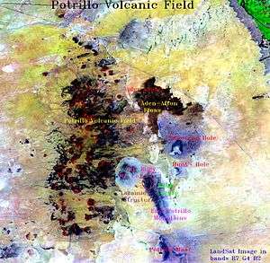
The Potrillo volcanic field is separated into three areas; the eastern, central and western alignments. This division is based on the essentially north-south distribution of volcanic centers, which is delineated by units east of the east Robledo fault. It goes across from north to south, the eastern alignment includes Santo Tomas, San Miguel, Little Clack Mountain and Black Mountain. Most of the eastern alignment are scoria cones with and without breach flows with pahoehoe surface.
The central alignment includes Aden, Afton, the Gardner cones, and the two maars; the Kilburne hole and Hunt’s hole. The two maars erupted through portions of pre-existing Afton series. The Afton flows may be a fissure-emplaced upon which the Gardner cones were made. Aden is a shield site of many tube-fed lavas with explosive characteristics.
The Western alignment affects The Western Potrillo Mountains, a cavalcade of hundreds of coalescing cones and flows formed upon older, thick platform was the result from possibly fissure-fed stacked flows. Also within the western area are several maars: Riley, Malpais, and Potrillo. Potrillo maar is included with the western alignment due to its position west of the East Robledo fault.
Volcanology II
A maar is a low relief volcanic crater produced by the interaction of rising magma and ground water and the product is shallow explosive eruptions. What happens is the heating and boiling of ground water when magma invades the ground water table and the explosions blast up through the surface. The result is a crater that looks similar to a hole that is often filled with water to form a lake. The range in size is from 60 to 2,000 metres (200 to 6,560 ft) across and form 10 to 200 metres (33 to 656 ft). There are maars in western USA, in the Eifel region of Germany and in geologically young volcanic region of the world, one of them is Hunt’s Hole and Kilbourne Hole located in Potrillo volcanic field, in Dona Ana New Mexico close to El Paso Texas. There are five maars in the Potrillo volcanic field.
A cinder cone also known as scoria cone, is a steep, conical hill formed on top of a vent. The cinder cones often occur in groups usually on the sides and around the shield volcanoes and the strato volcanoes. They are formed form lava fragments called cinders, it is magma that is glassy and has hundreds of gas bubbles that are frozen, it cools quickly after it is ejected into the air. The lava is expelled from the vent and formed around the vent when they fall back after it is ejected. Cinder cones are approximately 250 metres (820 ft) height and 500 metres (1,600 ft) in diameter.
The Potrillo volcanic field covers approximately 4,600 square kilometres (1,800 sq mi) of Doña Ana County. It is a monogenetic volcanic field that can be divided in three volcanic regions; the West Potrillo Field that consists of more than 100 Cinder Cones, two maar volcanoes and associated flows that covers approximately 1,250 square kilometres (480 sq mi). The Aden–Afton field has a number of young flows, three cinder cones and three maar volcanoes, one of them is the Kilbourne Hole; Aden-Afton Field is approximately 230 square kilometres (89 sq mi).
Aden Crater is a small shield cone, and it is the most unusual feature in the volcanic field because it has a lava tube, where a ground sloth skeleton was found. It is 11,000 years old, and is now at Yale's Peabody Museum of Natural History. This ground sloth (Nothrotheriops shastense) is one of the few specimens of this age which have been found with patches of skin and hair preserved.
Black Mountains–Santo Tomas is made up of basalt, it consists of four different eruptive centers near the Rio Grande. The West Potrillo field is the oldest part of the Potrillo volcanic field.
The Potrillo volcanic field has two important xenolith localities that are Kilbourne Hole and Potrillo maar where mantle peridotites, feldspathic granulites and kaersutite occur. Alkali feldspar, olivine and basalt were erupted during the middle and late quaternary. Rock samples collected in the northern part of the pyroclastic deposit of the Potrillo maar, and lava associated with a cinder cone yielded potassium–argon ages, approximately 1.29 and 1.18 million years. The magmatism is entirely basaltic forming scattered scoria cones. Several short lava flows were originated from each cone. There is a diverse rock types beneath the Potrillo volcanics, the range is from Proterozoic granites through a Phanerozoic sedimentary succession to basalt-andesite volcanics of the southern fringes of the Sierra de las Uvas volcanic field. The Potrillo area is generally classified as part of the southern Rio Grande rift and shows the Cenozoic tectonic evolution of that structure.
Structural geology
The structural geology of the East Potrillo Mountains was defined during three main periods:
During the Laramide, the thrust faults were overturned due to compression (Late Cretaceous – Early Cenozoic).
Deformation occurred during the Middle Cenozoic, and it is believed it involved either northeast or north-south extension (in the Rio Grande Rift). The system of low angle normal faults that resulted were closely spaced and consequently cut the Laramide structures. The extensional tectonics continued throughout the Middle Cenozoic.
Finally, during the Late Cenozoic tectonic uplift took place as a result of movement on high angle normal faults.[4]
Isotope geochemistry
Potrillo volcanic field contains alkaline basanitic lavas and cinder cones in the southernmost New Mexico.[5] La Mesa is a surface which formed between 900 and 700 Ka, which holds the lavas in the central and eastern region of the field.[6] There are three separate eruptive centers; Afton eruptive center which resides directly against La Mesa central province, the Aden complex which is a crater that lies above the Afton flows, lastly the Black Mountain, which is adjacent to a series of cinder cones.[7] When performing 3He surface exposure dating, the upper 3 centimetres (1.2 in) of flow surfaces is sufficient enough for collecting samples desired. It is essential to collect samples with primarily display flow features, such as spatter, flow lineation, and cooling rinds.[7] 3He surface dating is a technique that is optimal when working with well preserved young surface lavas (<700 ka).[7] All samples are analyzed on a static mass spectrometer equipped with ion counting detection. The mineral is first crushed in a vacuum, and the magmatic component of the mash is analyzed for its amount and isotropic composition of helium and neon. 3He is calculated by taking the difference of total 3He component equal to the total 4He released in the heating process times 3He/4He released in the crush step.[7] Cosmogenic 3He/21Ne confirm that 3He is retained be the samples taken.[7] Cosmogenic isotopes are rare isotopes created when a high-energy cosmic ray interacts with the nucleus of an atom. These isotopes are produced within earth materials such as rocks or soil, in Earth's atmosphere, and in extraterrestrial items such as meteorites.[8] By measuring cosmogenic isotopes, scientists are able to gain insight into a range of geological and astronomical processes.[8] There are both radioactive and stable cosmogenic isotopes. This assumes ⁴He released by heating is due to magmatic component with a helium isotopic composition which seems to be a reasonable assumption for a low uranium olivine.[7] Ne concentrations monitor assumption that 4He belongs to the magmatic component. Ne has 3 isotopes: 20Ne, 21Ne, and 22Ne. 22Ne is dominated by the magmatic component. 21Ne has a cosmogenic contribution.[7]
| Surface-exposure ages of samples from Potrillo volcanic field | ||
|---|---|---|
| Description | 3He/21Ne (melt) | Age “Ka” (melt) |
| Black Mountain | ||
| Upper flow associated | 2.6 ± 0.6 | 77 ± 4 |
| Cinder cone | 3.0 ± 0.5 | 85 ± 7 |
| Lower flow | 2.6 ± 0.5 | 69 ± 5 |
| Afton volcanic center | ||
| Flow resting on La Mesa | 2.4 ± 0.3 | 72 ± 4 |
| surface | 2.3 ± 0.3 | 81 ± 4 |
| Aden volcanic center | ||
| Flow collected 5 km | 2.5 ± 1.2 | 16.9 ± 3 |
| From Aden crater | N/A | 15.9 ± 2 |
| Spatter cone in Aden | N/A | 15.7 ± 2 |
| Crater | 1.5 ± 0.5 | 17.9 ± 2 |
| Lava lake within crater | N/A | 18.2± 3 |
Cinder cone morphology
The current morphology of the Potrillo volcanic field consists of over 100 cinder cones within the area of the Rio Grande Rift in southern New Mexico. The most recent age dating study revealed the age to be from 1 million to 20,000 years old. It is a 50 square kilometres (19 sq mi) field in S.E. Doña Ana County, NM.
There are 3 groups of slope angles;
- Group 1: age of around 250 Ka years old.
- Group 2: age of around 125 Ka years old.
- Group 3: age of around 60 Ka years old.
This process of grouping was done by 3He surface exposure dating and 40Ar/39Ar dating. The new morphologic dating methods suggest that cinder cone formation in the Potrillo volcanic field may have occurred at different intervals and that the field may be currently developing new cinder cones. The cinder cone slope distribution in the Potrillo volcanic field suggests that volcanism occurred at different time intervals. In addition, trend line analysis provides a powerful and useful tool for predicting cinder cone ages in the Potrillo volcanic field. This area has arid climate & cone degradation is a product of mechanical weathering.
The age-angle relationship is quantitatively modeled by diffusion equations, like Comparison of 3He to 40Ar/39Ar, and by overlapping DRG digital elevation models, digital topographic maps DEM. The formula angle = tan−1(height/radius) was used to obtain the angles. The overall comparison of all groups in the south west region extending from New Mexico to Mexico are used for the dating and comparison of age but the climate, and terrain conditions are looked to see the weathering conditions.
Fault scarps
The approximate age of the East Potrillo’s faulting is estimated to be around 57,000 to 377,000 years. The age of the faulting was determined by the utilization of three different processes that show similar results on the dates of the faulting on the east Potrillo mountains that is caused by the Rio Grande rift. The first method to determine age was the scarp heightslope- angle relationship created by Buckman and Anderson in 1979.[9] The maximum scarp angle increases approximately linearly with the logarithm of the scarp height. In other terms, plotting the maximum height of a slope versus the maximum slope angle allows the age of the fault to be estimated; since the shallower the angle is the older the fault scarp becomes.
The second method used was the linear-plus-cubic diffusion, which is a model of fault scarping. This method uses the diffusive process on hill slopes, such as rain-splash and wind erosion, that move sediment down hill. t = t’(SO)*2/k (0). The last method used to date the faulting was the morphologic dating without numerical model. Such a technique requires that down slope debris instability is a timedependent function of slope angle, in units of volume per time per length of contour (Nash, 2005). The scarp ages can be determined based on the relationship Ta/Tb = H*-2 b / H-2 b From the first method we can conclude that there were at least five seismic events that did not occur at the same time. From method two we can say than the faulting ages between 57ka to 377ka with surface offset of 11.2m that had a magnitude of 6-7 earthquakes. Finally the third method of dating concludes that the relative ages of the east Potrillo fault scarps ranges form 153,000 to 239,000.
Peridotite xenoliths
Kilbourne Hole xenoliths are divided according to their textures into:
- fine grained lherzolite
- protogranular to porphyroclastic lherzolite
- porphyroclastic olivine-rich peridotite[10]
- Age: Middle-late Quaternary: 1-Ma – 8-ka
- Temperatures: Equigranular 978-984 C, lherzolite 1020-1044 C, olivine-rich 1052-1184 C
- Xenoliths were derived from 35 to 70 km deep
- Calculated P-wave velocities for Peridotite range from 7.75 km/s to 7.89 km/s
- Rio Grande Rift P-wave velocities range from 7.6 km/s to 7.8 km/s
Pyroxenites
A pyroxenite is defined as an ultra mafic rock that is composed of by and large of minerals of the pyroxene group for example enstatite, bronzite or diopside and are sorted into clinopyroxenite, orthopyroxenite and the websterites. Pyroxenites have been located as layers inside large masses of peridotite. These pyroxenite layers have come to be inferred as a yield of the reaction between rising magmas and peridotite of the upper mantle. The Southern Rio Grande Rift, including the Portrillo volcanic field, is an area where pyroxenites are most prevalent. Pyroxenites are generally coupled with zones of extension implying that there is a correlation between asthenospheric outpouring and invasive growth of mantle pyroxenites. The methods by which pyroxenites are formed is somewhat undefined. Pyroxenites may possibly represent preserved remnants of Farallon (oceanic) plate that subducted under the North American plate and mixed with mantle melts and created the xenoliths that have surfaced in Kilbourne Hole and Potrillo Maar. However others suggest that they could be cumulates derived from alkali basaltic pyroxenite samples continue to preserve a more widespread reaction which is specifically helpful in examining the thermal and chemical alteration of the Rio Grande rifting. More evidence showing this rock contact and with melt deep in the mantle is that primary mantle carbonates are present in many of the pyroxenites found in the Rio Grande Rift magmas or primary melt compositions that crystallized in the upper mantle.
Geophysics
Recently, velocity data was acquired using both reflected and refracted arrivals. This data has shown that the upper 5 km of the crust beneath the Portillo volcanic field (PVF) is characterized by alternating regions of low and high velocities of 2.5-3.7 km/s and 3.5-4.3 km/s, respectively. The velocities increase with depth to approximately 6.0 km/s at 10 km, 6.5 km/s at 16 km, and they increase sharply from 6.9 to 8.0 km/s between 28 and 38 km.
The low crust of the PVF consists of a single density of 2880 kg/m3. The upper to middle crust (between 5 km and 20 km) of the PVF has a block with a density of 2740 kg/m3. The density at 11 to 15 kilometres (6.8 to 9.3 mi) of depth is 2880 kg/m3. This body is a mid-crustal “welt” and velocities within this region increase up to and greater than 6.35 km/s. This greater density creates a lateral density contrast and in turn generates long-wavelength gravity high. The upper mantle densities at the PVF are decreased from 3280 to 3250 kg/m3. Evidence of this can be supported by the west to east decrease in velocities from approximately 7.96 to 7.70 km/s.
Coyote Hill and the West Portillo mountains make up the western portion of the PVF, with region velocities in this uplift from 4.5 km/s to over 6.0 km/s at the depth of 2.5 km. To the east is the Malpais basin and velocities within this basin range from 1.68 km/s to 4.86 km/s at a depth of approximately 3 km. The Mesilla basin is an asymmetric basin that adjoins the eastern edge of the PVF and extends on to the western flank of the Franklin mountain uplift. At a depth of about 1.5 km the velocities in the western area range from approximately 2.4 km/s to 4.0 km/s at a depth of about 1.5 km.
There is increased seismic reflectivity within the crust and at the Moho interface concentrated below the PVF. The mid-crustal shows reflectivity increases between 40 and 70 kilometres (25 and 43 mi) offset; mid-crustal reflectivity is present between 4 and 6 seconds, reduced time.[10][11]
Notable vents
| Name | Elevation | Coordinates | Last eruption |
| Aden Crater[1] | - | - | - |
| Hunt's Hole[1] | - | - | - |
| Kilbourne Hole[1] | 1,292 m or 4,239 ft | 31°58′N 106°58′W / 31.97°N 106.97°W | 80,000 years ago |
| Malpais tuff ring[1] | - | - | - |
| Potrillo Maar[1] | - | - | - |
| Mount Riley[1] | - | - | - |
See also
| Wikimedia Commons has media related to Potrillo Volcanic Field. |
Notes
- 1 2 3 4 5 6 7 8 9 10 11 12 13 14 Wood, Charles A.; Jűrgen Kienle (1993). Volcanoes of North America. Cambridge University Press. pp. 310–313. ISBN 0-521-43811-X.
- ↑ Mack, G. H.; K. A. Giles (2004). The Geology of New Mexico: A Geologic History. New Mexico Geologic Society. pp. 331–353.
- ↑ Mack, G. H.; W. R. Seager (1995). "Transfer zones in the southern Rio Grande Rift". Journal of the Geological Society. 152 (3): 551–560. doi:10.1144/gsjgs.152.3.0551.
- ↑ Seager, W. R.; Mack, G.H (1994). Geology of the East Potrillo Mountains and vicinity Dona Ana County, New Mexico. New Mexico: New Mexico Bureau of Mines and Mineral Resources.
- ↑ Anthony E. Y., Hoffer J. M., Waggoner W. K., and Chen W. (1992) Compositional diversity in late Cenozoic mafic lavas in the Rio Grande rift and Basin and Range province, southern New Mexico. Geol. Soc. Amer. Bull. 104, 973-979.
- ↑ Mack G. H., Salyards S. L., and James W. C. (1993). Magnetostratigraphy of the Plio-Pleistocene Camp Rice and Palomas formations in the Rio Grande rift of southern New Mexico. American Journal of Science, v. 293, p. 49-77.
- 1 2 3 4 5 6 7 Anthony E. Y., Poths J., (1992) 3He surface exposure dating and its implications for magma evolution in the Potrillo volcanic field, Rio Grande Rift, New Mexico, USA. Geochimica et Cosmochimica Acta Vol. 56, pp. 4105-4108.
- 1 2 Gosse, John C., and Phillips, Fred M. (2001). "Terrestrial in situ cosmogenic nuclides: Theory and application". Quaternary Science Reviews 20, 1475-1560.
- ↑ Buckman, R.; Anderson, R. (January 1979). "Estimation of fault-scarp ages from a scarp-height-slopeangle relationship". Geology. Denver, CO: U. S. Geol. Surv. 7 (1): 11–14. Bibcode:1979Geo.....7...11B. doi:10.1130/0091-7613(1979)7<11:EOFAFA>2.0.CO;2.
- 1 2 Hamblock, J.M.; et al. (2007). "A composite geologic and seismic profile beneath the southern Rio Grande rift, New Mexico, based on xenolith mineralogy, temperature, and pressure". Tectonophysics. 442 (1–4): 14–48. Bibcode:2007Tectp.442...14H. doi:10.1016/j.tecto.2007.04.006.
- ↑ Averill M, 2007. A Lithospheric Investigation of the Southern Rio Grande Rift. Ph D Dissertation; University of Texas at El Paso. p 1-213
References
- Baldridge, S. W. (2004). Geology of the American Southwest: A Journey through One Billion Years of Plate-Tectonic History. Cambridge University Press. pp. 232–244.
- Barbeau, Marius (1935). "Volcanoes on the Nass". Canadian Geographical Journal. X (5): 215–225.
- Chapin, CE Cather, SM (1994). "Tectonic setting of the axial basins of the northern and central Rio Grande rift". Geological Society of America Special Paper. 291: 5–21. doi:10.1130/spe291-p5.
- Cordell, L (1975). Combined geophysical studies at Kilbourne Hole maar, New Mexico. New Mexico Geological Society Guidebook. 26th Field Conference. as recorded in: Charles A. Wood and Jurgen Kienle, eds. (1990). Volcanoes of North America: United States and Canada p. 310.
- Galvan-Ramirez, IN Montalvo-Arrieta, JC (2007). The historical seismicity and Prediction of ground motion in northeast Mexico. Journal of South American Earth Sciences.
- Garcia, ME Miller JG, Anthony EY. Morphologic analysis of quaternary cinder cones, Potrillo volcanic field, New Mexico. Undergraduate Research (Posters). University of Oklahoma, College of Geological Society of America Abstracts with Programs. 38. Session No. 10--Booth# 3. p. 34. Department Of Geological Sciences, The University of Texas at El Paso.
- Halley, JW (1978). Guidebook the Rio Grande rift in New Mexico and Colorado. New Mexico Bureau of Mines and Mineral Resources. pp. 13–55.
- Krafft, M (1993). Volcanoes, Fire from Earth. London, United Kingdom: Thames and Hudson. ISBN 0-8109-2844-2.
- Lipman, PW Mehnert, HH (1975). Late Cenozoic basaltic volcanism and development of the Rio Grande depression in the southern Rocky Mountains. Geological Society of America. Mem.(144). pp. 119–154. doi:10.1130/mem144-p119.
- Min, KR Peter W, Wolff JA, Mundil R, Winters RL (2006). (U-Th)/He dating of volcanic phenocrysts with high-U-Th, Jemez Volcanic Field. New Mexico. Chemical Geology. V. pp. 223–235. I (3-4).
- Porreca, C Selverstone J, Samuels K (2006). Pyroxenite Xenoliths from the Rio Puerco volcanic field, New Mexico: Melt metasomatism at the margin of the Rio Grande Rift. Geosphere. 2. pp. 333–351. doi:10.1130/ges00058.1.
- Sharp, JW (2007). Potrillo Volcanic Field. Volcanoes in the Desert. Desert USA.
- Souther, JG, (1992). The late Cenozoic Mount Ediziza Volcanic complex, British Columbia. Geological Suver of Canada. pp. 420, 320. doi:10.4095/133497. Memoir.
- Stormer, JC, Jr. (1987). Capulin Mountain volcano and the Raton–Clayton volcanic field, northeastern New Mexico. Geological Society of America Field Guide - Rocky Mountain Section. pp. 421–424. doi:10.1130/0-8137-5402-x.421.
- Tilling (1985). Volcanoes. USGS General Interest Publication. ISBN 0-89490-151-6.
- Ulrich, GE Condit CD, Wenrich KJ, Wolfe WE, Holm RF, Nealey LD, Conway FM, Aubele JC, Crumpler LS (1989). Chapin, C.E. and Zidek, J, eds, eds. Excursion 5A Miocene to Holocene volcanism and tectonism of the southern Colorado Plateau, Arizona. Field excursions to volcanic terranes in the western United States. V. pp. 1–41.
- West, M Ni J, Baldridge SW, Wilson D, Aster R, Gao W, and Grand S (2004). Crust and upper mantle shear wave structure of the southwest United States; Implications for rifting and support for high elevation. Journal of Geophysical Research. V.
- Wood, Kienle (1990). Volcanoes of North America: United States and Canada. Cambridge University Press. p. 354. ISBN 0-521-36469-8. Contribution by: Crumpler LS, Aubele JC. Volcanic maar north of Red Hill Maar.