Potosi Mining District
This article is about a former mining district in Clark County, Nevada, United States. For the much larger and more famous silver-mining locale in Bolivia, South America, see Potosí.
- The current Potosi Mining District in Humboldt County, Nevada is a major world-class producer of gold and includes the Pinson, Twin Creeks, Turquoise Creek and Getchell mines.[1] There was a Potosi mine in Lincoln County, Nevada.[2]
|
Potosi | |
|
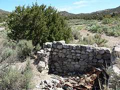
Ruins near Potosi Spring | |
| Location | S of Las Vegas off I-15 near Potosi Pass |
|---|---|
| Nearest city | Las Vegas, Nevada |
| Area | 9,600 acres (3,900 ha) |
| MPS | Site |
| NRHP Reference # | 74001144 |
| Added to NRHP | November 13, 1974 |
The Potosi mining district, or Potosi, was an area in Clark County of southern Nevada, U.S. It is listed on the National Register of Historic Places and includes three structures.[3] The town was named after the famous silver-mining city of Potosi, Bolivia.[4]
History
The mines in the area produced gold, silver, zinc, platinum, copper, palladium, cobalt, nickel, and antimony.[5][6] A small amount of carnotite (a vanadium-uranium mineral) was also discovered, but not mined.[7]
Geography
The site of Potosi or Potosi Camp is at an elevation of 5,705 feet (1,739 m) above sea level.[8]
Included mines
Potosi mining district was a part of the Goodsprings Mining District and included the following mines:[5][6]
- Christmas Mine
- Dawn Mine
- Green Monster Mine
- Kirby Mine
- New Year Mine
- Shenandoah Mine
- Ninetynine Mine
See also
References
- ↑ Tingley, Joseph V. (1998). Mining Districts of Nevada (pdf). Bulletin 47 (2 ed.). Reno, NV: Nevada Bureau of Mine and Geology. p. 177. Retrieved 20 July 2014.
- ↑ History of the Potosi mine Retrieved 7 December 2008.
- ↑ "Nevada -- Clark County -- Historic districts". National Register of Historic Places. Retrieved 31 July 2011.
- ↑ Helen S. Carlson (1974) Nevada Place Names, Reno: University of Nevada Press, ISBN 0-87417-094-X, 9780874170948, p.194. Retrieved 7 December 2008
- 1 2 "Mines of Clark County, Nevada". ancestry.com. Retrieved 2008-10-12.
- 1 2 "Re: Collecting near Las Vegas (lost wages) nevada". Retrieved 2008-10-12.
- ↑ Francis Church Lincoln (1923) Mining districts and Mineral Resources of Nevada, reprinted 1982, Las Vegas: Nevada Publications, p.29-33.
- ↑ Geographic Names Information System: Potosi (historical) Retrieved 8 December 2008.
Coordinates: 35°58′15″N 115°32′27″W / 35.97083°N 115.54083°W
This article is issued from Wikipedia - version of the 10/16/2016. The text is available under the Creative Commons Attribution/Share Alike but additional terms may apply for the media files.