Possession Bay
Possession Bay is a bay 2 miles (3.2 km) wide which recedes southwest for 5 miles (8 km), entered southeast of Black Head on the north coast of South Georgia, an island in the southern Atlantic Ocean.
Cook's Second Voyage
It was discovered and named by a British expedition under Cook in 1775. Cook made the first known landing on South Georgia in this vicinity.
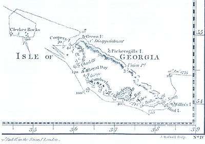
The great mariner Captain James Cook in HMS Resolution accompanied by HMS Adventure made the first landing, survey and mapping of South Georgia. As mandated by the Admiralty, on 17 January 1775 he took possession for Britain and renamed the island "Isle of Georgia" for King George III. German naturalist Georg Forster, who accompanied Cook during their landings in three separate places at Possession Bay on that day, wrote:
- "Here Captain Cook displayed the British flag, and performed the ceremony of taking possession of those barren rocks, in the name of his Britannic Majesty, and his heirs forever. A volley of two or three muskets was fired into the air."
Cook himself wrote in his log:
- "The head of the Bay... was terminated by a huge Mass of Snow and ice of vast extent, it shewed a perpendicular clift of considerable height, just like the side or face of an ice isle; pieces were continually breaking from them and floating out to sea. A great fall happened while we were in the Bay; it made a noise like Cannon. The inner parts of the Country was not less savage and horrible... the wild rocks raised their lofty summits until they were lost in the clouds, and the valleys lay buried in everlasting snow. Not a tree was to be seen nor a shrub even big enough to make a tooth-pick."
References
- Stonehouse, B (ed.) Encyclopedia of Antarctica and the Southern Oceans (2002, ISBN 0-471-98665-8)
Coordinates: 54°6′S 37°7′W / 54.100°S 37.117°W
![]() This article incorporates public domain material from the United States Geological Survey document "Possession Bay" (content from the Geographic Names Information System).
This article incorporates public domain material from the United States Geological Survey document "Possession Bay" (content from the Geographic Names Information System).
Capital: King Edward Point (Grytviken) | |
| General | |
| Settlements / Whaling stations | |
| South Georgia islands | |
| South Sandwich islands | |
| Landmarks |
|