Porta San Paolo
.jpg)
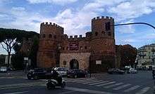
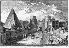
The Porta San Paolo (San Paolo Gate) is one of the southern gates in the 3rd-century Aurelian Walls of Rome, Italy. The Via Ostiense Museum (museo della Via Ostiense) is housed within the gatehouse. It is in the Ostiense quarter; just to the west is the Pyramid of Cestius, an Egyptian-style pyramid, and beyond that is the Protestant Cemetery.
History
The original name of the gate was Porta Ostiensis, because it was located of the beginning of via Ostiense, the road that connected Rome and Ostia where functioned as its main gate. Via Ostiense was an important arterial road, as evidenced by the fact that upon entering the gate of the same name, the road split, with one direction leading to the famous Emporium, the great market of Rome.
The gatehouse is flanked by two cylindrical towers, and has two entrances, which had been covered by a second, single-opening gate, built in front of the first by the Byzantine general Belisarius (530s–540s).
The structure is due to Maxentius, in the 4th century, but the two towers were heightened by Honorius. Its original — Latin — name was Porta Ostiensis, since it opened on the way to Ostia. Later, it was renamed to the Italian Porta San Paolo, because it was the exit of Rome that led to the Basilica of St. Paul Outside the Walls.
In 549, the Rome was under siege; the Ostrogoths of Totila entered through this gate, because of the treason of the Isaurian garrison. On 10 September 1943, two days after the armistice between the Allies and Italy had been agreed, Italian military and civil forces tried to block German seizure of the city, with 570 casualties.
Sources
- Quercioli, Mauro (2005). Le mura e le porte di Roma. Rome: Newton & Compton.
- Cozzi, Laura G. (1968). Le porte di Roma. Rome: F. Spinosi.
External links
| Wikimedia Commons has media related to Porta San Paolo (Rome). |
- Information, including a photograph (Italian)
- Further information (Italian)
Coordinates: 41°52′36.02″N 12°28′53.29″E / 41.8766722°N 12.4814694°E