Port Adelaide railway station
Port Adelaide | |||||||||||
|---|---|---|---|---|---|---|---|---|---|---|---|
 | |||||||||||
| Location |
Baynes Place Port Adelaide | ||||||||||
| Line(s) | Outer Harbor Line | ||||||||||
| Distance | 11.7 km from Adelaide | ||||||||||
| Platforms | 2 | ||||||||||
| Bus routes |
118 to Port Adelaide & City 136 to Port Adelaide & City 150 to Osborne & City 153 to Port Adelaide & City 230 to Port Adelaide & City 232 to Port Adelaide & City 254 to Port Adelaide & City 361 to Port Adelaide & Westfield Tea Tree Plaza | ||||||||||
| Construction | |||||||||||
| Parking | Yes | ||||||||||
| Bicycle facilities | No | ||||||||||
| History | |||||||||||
| Opened | 1916 | ||||||||||
| Rebuilt | 1971 & 2010 | ||||||||||
| Services | |||||||||||
| |||||||||||
Port Adelaide station is located on the Outer Harbor line.[1] Situated in the north-western Adelaide suburb of Alberton, it is 11.7 kilometres from Adelaide station.
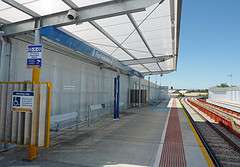
Port Adelaide station’s two elevated platforms are on a viaduct that carries the railway across Commercial Road. The station is unstaffed and has no buildings or other facilities except basic passenger shelters on each platform.
History
The line from Adelaide to Port Adelaide was the second railway in South Australia, after the Goolwa-Port Elliot railway, opened in 1854, and opened in 1856.[2] The line operated for 60 years before today’s Port Adelaide station was built.
The original line from Adelaide ran directly to Port Dock station, the site now occupied by the National Railway Museum. Various lines then continued through the Port Adelaide’s streets to the wharves and, from 1878, along St Vincent Street to the seaside town of Semaphore.
Congestion at Port Dock and the delays involved in operating trains along busy streets in the centre of the Port resulted in construction of a viaduct and a new bridge across the Port River in 1916. This diverted through trains to Semaphore and Outer Harbor via a new station named Port Adelaide Commercial Road, the current station.
Port Adelaide Commercial Road was quite a substantial building, with long platforms, an overall roof and a signal cabin. This quickly took over from Port Dock as the town’s principal railway station.
As rail traffic decreased through the 1960s and 70s, facilities at Commercial Road station were gradually reduced. In the early 1970s the roof was removed, platforms shortened and the street level station buildings reconstructed. The ticket office closed in January 1979 and the station has been unstaffed since then.
With the closure of Port Dock in 1981, Commercial Road station was renamed Port Adelaide.
The tracks through Port Adelaide station were dual gauge, both 5 ft 3 in (1,600 mm) broad gauge and 4 ft 8 1⁄2 in (1,435 mm) standard gauge. This allowed freight traffic from Dry Creek via the Rosewater loop to access industrial facilities on the Lefevre Peninsula and the container terminal at Pelican Point. In August 2008, freight traffic was diverted to operate via the Mary Mackillop Bridge downstream of the Port Adelaide harbour.[3] The disused standard gauge rails have been removed, however the dual gauge sleepers remain in place with the entire Outer Harbor line to be gauge converted in the future.
In November 2009, the station and viaduct closed for refurbishment, reopening on 9 May 2010.[4]
Services by platform
| Platform | Lines | Destinations | Notes |
|---|---|---|---|
| 1 | Outer Harbor | all stops services to Outer Harbor | some peak hour services terminate at Osborne |
| 2 | Outer Harbor | all stops services to Adelaide |
Tranport links
| Bus Transfers: Stop 38 (Commercial Road) | |
| Route No. | Destination & Route Details |
| |
City via Old Port Road, Tapleys Hill Road, Trimmer Parade, Crittenden Road, Grange Road & Port Road[5] |
| |
City via Webb Street, Frederick Road, Westfield West Lakes, Henley Beach and Henley Beach Road (136F does not stop between Stop 18 & City)[6] |
| |
City via Port Road[7] |
| |
Osborne via Fletcher Road, Carnarvon Terrace & Victoria Road[7] |
| |
City via Port Road[8] |
| |
City via Addison Road, Arndale Central & Torrens Road[9] |
| |
City via Newcastle Street, Centro Arndale & Torrens Road[10] |
| |
City via Grand Junction Road, Hanson Road, Arndale Central & Hawker Street (254X does not stop between Arndale & North Adelaide)[11] |
| |
Tea Tree Plaza Interchange via Grand Junction Road, Helen Terrace & Wright Road[12] |
References
- ↑ Outer Harbor & Grange timetable Adelaide Metro 23 February 2014
- ↑ "The Centenary of the Adelaide-Port Adelaide Railway'" Strempel, A.A. Australian Railway Historical Society Bulletin June 1956 pp69-83
- ↑ Premier Mike Rann opens the Diver Derrick and Mary Mackillop road and rail bridges at Pt Adel ABC News 1 August 2008
- ↑ Port Adelaide Viaduct Upgrade Department of Planning, Transport & Infrastructure
- ↑ Route 118 Adelaide Metro
- ↑ Route 136 Adelaide Metro
- 1 2 Route 150 Adelaide Metro
- ↑ Route 153 Adelaide Metro
- ↑ Route 230 Adelaide Metro
- ↑ Route 232 Adelaide Metro
- ↑ Route 254 Adelaide Metro
- ↑ Route 361 Adelaide Metro
Further reading
- Rails Through Swamp and Sand – A History of the Port Adelaide Railway. M. Thompson pub. Port Dock Station Railway Museum (1988) ISBN 0-9595073-6-1
External links
 Media related to Port Adelaide railway station at Wikimedia Commons
- Track map SA Signal & Track
- Flickr gallery
Coordinates: 34°50′57″S 138°30′27″E / 34.849206°S 138.507587°E