Poor Knights Islands
| Tawhiti Rahi (Māori) | |
|---|---|
 | |
| Geography | |
| Location | Northland, New Zealand |
| Coordinates | 35°30′S 174°45′E / 35.500°S 174.750°E |
| Area | 24 km2 (9.3 sq mi) |
| Administration | |
|
New Zealand | |


The Poor Knights Islands are a group of islands off the east coast of the Northland Region of the North Island of New Zealand. They lie 50 kilometres (31 mi) to the north-east of Whangarei, and 22 kilometres (14 mi) offshore halfway between Bream Head and Cape Brett. Uninhabited since the 1820s, they are a nature reserve and popular underwater diving spot. The Poor Knights Islands Marine Reserve surrounds the island. The islands' name is said to derive from their resemblance to Poor Knight's Pudding, a bread-based dish popular at the time of discovery by Europeans.
Description
The chain consists of two large islands (Tawhiti Rahi, the larger at 151.5 ha (374 acres), and Aorangi (101 ha (250 acres)))[1] with a group of smaller islets between the two, the largest of which is Motu Kapiti. Tawhiti Rahi is also the Māori name for the entire chain, which has a total area of 271 ha (670 acres).[2] The islands are the eroded remnants of a 4-million-year-old rhyolitic volcano.
Oceanography
Spring tide range for the islands is around 2 m (6.56 ft), decreasing to a neap tide of around 1 m (3.28 ft). The deep water around the island results in only moderate tidal currents. These are around the same magnitude as the prevailing shelf currents. In the general vicinity of the islands mean flows are around 0.2 m/s (0.656 ft/s) and run toward the southeast.[3] A remarkable feature of the region is the large internal tides that occur. These are a form of internal wave driven by the local tidal flow forcing the stratification against sloping areas of the shelf face. The surface manifestation of these waves can be seen from space.[4] These waves generate brief highly localized accelerations. Internal wave amplitudes of around 100 m (109 yd) have been observed, generating flow speeds as great as 0.5 m/s (1.64 ft/s).[5]
Environment
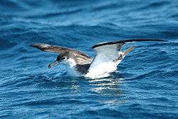
The islands are protected as a nature reserve and a permit is required to land or tie boats up. Permits are usually granted only for scientific research. A notable native plant of the islands is the spectacularly flowering Poor Knights lily. Feral pigs, which had roamed Aorangi since the departure of Māori in the 1820s, were exterminated in 1936.[6] The islands have been identified as an Important Bird Area, by BirdLife International because they are home to a breeding population of about 200,000 pairs of Buller's shearwaters.[7]
History
The islands were earlier inhabited by Māori of the Ngāti Wai tribe who grew crops and fished the surrounding sea. The tribe traded with other Maori.
A chief of the tribe named Tatua led his warriors on a fighting expedition to the Hauraki Gulf with Ngā Puhi chief Hongi Hika in the early 1820s. While they were away, a slave escaped the islands and travelled to Hokianga where he told Waikato, a chief of the Hikutu tribe, that the islands had been left undefended. As Waikato had been offended by Tatua some years previous, he and his warriors set out on three large canoes to attack the islands. They arrived at the islands one night in December 1823[8] and soon overpowered the islanders in the absence of their warriors. Many islanders jumped off the high cliffs to avoid being taken as slaves. Tatua's wife and daughter were captured and taken to the mainland where a distant relative recognised the wife and helped the two to escape.
Tatua returned to the islands to find a scene of destruction. Only nine or ten people were left on the islands, including his five-year-old son who had been hidden in a cave during the attack. The islands were declared tapu and Tatua left with the survivors and went to Rawhiti in the Bay of Islands where he unexpectedly found his wife and daughter.[9][10][11]
See also
- List of islands of New Zealand
- List of volcanoes in New Zealand
- Poor Knights Islands nonmarine fauna
References
- ↑ West, Carol J. (1999). Poor Knights Islands weed control programme, Conservation Advisory Science Notes No. 233, Department of Conservation, Wellington.
- ↑ Beever, Jessica E. (1986). Mosses of the Poor Knights Islands, northern New Zealand, Journal of the Royal Society of New Zealand 16 (3), 259–273.
- ↑ Sharples, J.; Greig, M. J. N. (1998). "Tidal currents, mean flows, and upwelling on the north-east shelf of New Zealand". N. Z. J. Mar. Freshwater Res. 32: 215–231. doi:10.1080/00288330.1998.9516821.
- ↑ Sharples; et al. (2001). "Internal tide dissipation, mixing, and vertical nitrate flux at the shelf edge on NE New Zealand". J. Geophys. Res. 106: 14069–14081. Bibcode:2001JGR...10614069S. doi:10.1029/2000jc000604.
- ↑ Stevens, C.L.; Abraham, E.R.; Moore, C.M.; Boyd, P.W.; Sharples, J. (2005). "Observations of Small-Scale Processes Associated with the Internal Tide Encountering an Island". J. Phys. Oceanogr. 35: 1553–1567. doi:10.1175/JPO2754.1.
- ↑ Cranwell, L.M.; Moore, L.B. (1938). "Intertidal Communities of the Poor Knights Islands, New Zealand". Transactions and Proceedings of the Royal Society of New Zealand. 67.
- ↑ BirdLife International. (2012). Important Bird Areas factsheet: Poor Knights Islands. Downloaded from http://www.birdlife.org on 2012-02-04.
- ↑ Borley, Craig (May 27, 2008). "'Maori Pompeii' yields treasures". The New Zealand Herald. Retrieved November 3, 2011.
- ↑ "Poor Knights Islands Marine Reserve", Department Of Conservation, New Zealand.
- ↑ The Poor Knights and The Poor Squires (The Pinnacles) Geology. Whangarei Deep Sea Anglers Club. Accessed 2008-05-31.
- ↑ "Whakapapa", The Patuone Website.
External links
| Wikivoyage has a travel guide for Diving the Poor Knights Islands. |
- "Geology – New Zealand's Geological History", from An Encyclopaedia of New Zealand, edited by A. H. McLintock, originally published in 1966. Te Ara - The Encyclopedia of New Zealand, updated 2006-09-26. Accessed 2007-04-15.

Coordinates: 35°30′S 174°45′E / 35.500°S 174.750°E