Poolbeg Lighthouse
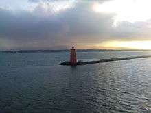 Poolbeg Lighthouse at sunset | |
 Poolbeg Lighthouse Ireland | |
| Location | Dublin, Ireland |
|---|---|
| Coordinates | 53°20′31.8″N 6°09′04.7″W / 53.342167°N 6.151306°W |
| Year first constructed | 1767 |
| Construction | limestone |
| Tower shape | cylindrical tower with balcony and lantern |
| Markings / pattern | red painted |
| Height | 20 metres (66 ft) |
| Focal height | 20 metres (66 ft) |
| Characteristic | red light 8 s on, 4 s off, 4 s on, 4 s off |
| Admiralty number | A5882 |
| NGA number | 6620 |
| ARLHS number | IRE-057 [1] |
Poolbeg Lighthouse in Dublin Bay was built in 1768 and initially operated on candlepower (reputedly the first in the world to do so) but changed to oil in 1786. It was re-designed and re-built into its present form in 1820.[2]
Location
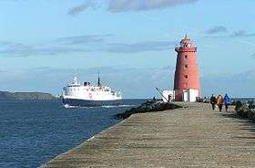
The lighthouse, one of a formation of three, is located on the Great South Wall (South Bull Wall), at the Port of Dublin, which extends from Ringsend nearly four miles out into Dublin Bay. The wall was the world's longest at the time of its building, and remains one of the longest sea-walls in Europe. One of the other two lighthouses is located on the Bull Wall opposite, and the other on a wooden platform mid-channel.
The Poolbeg Lighthouse is a handsome and conspicuous feature in the bay, in which it occupies an almost central position. It is nearly equidistant from Dublin, Dún Laoghaire, and Howth, and commands extensive views of the shores of the bay, with an unbroken panorama of the mountains on the south. Howth with its heather-clad hills, its bright green fields and rugged reaches of sea cliffs, looks particularly attractive from this point.[3][4]
Original building

The lighthouse when originally constructed, presented an entirely different appearance from what it does at the present time. It was not as high as the existing structure, it sloped much more rapidly towards the top, and was surmounted by an octagonal lantern with eight heavy glass windows. A stone staircase with an iron balustrade led to the second storey, where an iron gallery surrounded the whole building.
The alteration to the present form was made in the early part of the nineteenth century.[5]
Management
The lighthouse, automated for many years, is managed by Dublin Port Company, whereas most lighthouses in Ireland are managed by the Commissioners of Irish Lights, today part of a larger cross-border body.
Standard height measurement for Ordnance Survey Ireland

Historically, the Ordnance Survey Ireland used the low water mark of the spring tide on 8 April 1837 at the Poolbeg Lighthouse as a standard height for all its maps,[6] a practice which continued up until 1958.
Colouring

The Poolbeg Lighthouse is painted red. The green lighthouse in Dublin bay is the North Bull lighthouse, a couple of yards off the end of the North Bull Wall, and another lighthouse sits out in the bay itself. As with all navigational aides marking a channel, the port side as one heads upstream is indicated by red markers whilst the right hand side or starboard of the channel is green.
See also
References
- ↑ Lighthouses Directory
- ↑ Great South Wall - Great South Wall
- ↑ History of Poolbeg Yacht, Boat Club & Marina Dublin near South Wall Walk
- ↑ "RTÉ Radio One, Mooney Goes Wild". RTÉ News.
- ↑ Neighbourhood of Dublin: Poolbeg Lighthouse and the South Wall Extension, Irishtown, Sandymount, Beggardbush and Baggotrath
- ↑ "Irish Grid Reference System". Ordnance Survey Ireland. Retrieved 22 October 2010.
External links
| Wikimedia Commons has media related to Poolbeg Light. |
Coordinates: 53°20′32″N 6°09′06″W / 53.3421°N 6.1517°W
Irish lighthouses | ||
|---|---|---|
Lighthouses are shown in anti-clockwise sequence beginning from the north and proceeding west, south, east, and back to north. | ||
| County Donegal |
|  |
| County Sligo |
| |
| County Mayo |
| |
| County Galway |
| |
| County Clare |
| |
| County Kerry |
| |
| County Cork |
| |
| County Waterford |
| |
| County Wexford | ||
| County Wicklow | ||
| County Dublin |
| |
| County Louth | ||
| County Down |
| |
| County Antrim |
| |