Ponteranica
| Ponteranica | |
|---|---|
| Comune | |
| Comune di Ponteranica | |
|
Ponteranica | |
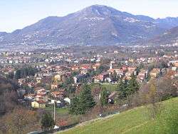
 Ponteranica Location of Ponteranica in Italy | |
| Coordinates: 45°44′N 9°39′E / 45.733°N 9.650°ECoordinates: 45°44′N 9°39′E / 45.733°N 9.650°E | |
| Country | Italy |
| Region | Lombardy |
| Province / Metropolitan city | Province of Bergamo (BG) |
| Area | |
| • Total | 8.4 km2 (3.2 sq mi) |
| Elevation | 545 m (1,788 ft) |
| Population (Dec. 2004) | |
| • Total | 6,866 |
| • Density | 820/km2 (2,100/sq mi) |
| Demonym(s) | Ponteranichesi |
| Time zone | CET (UTC+1) |
| • Summer (DST) | CEST (UTC+2) |
| Postal code | 24010 |
| Dialing code | 035 |
| Website | Official website |
Ponteranica is a comune (municipality) in the Province of Bergamo in the Italian region of Lombardy, located about 50 kilometres (31 mi) northeast of Milan and about 4 kilometres (2 mi) northwest of Bergamo. As of 31 December 2004, it had a population of 6,866 and an area of 8.4 square kilometres (3.2 sq mi).[1]
Ponteranica borders the following municipalities: Alzano Lombardo, Bergamo, Ranica, Sorisole, Torre Boldone, Zogno.
A part of is surfrace is occupied by Maresana Hill. The source of Morla is in Ponteranica.Part of Ponteranica's territory belonges of Parco dei Colli di Bergamo
Demographic evolution

References
External links
This article is issued from Wikipedia - version of the 8/16/2016. The text is available under the Creative Commons Attribution/Share Alike but additional terms may apply for the media files.