Pont d'Austerlitz
| Pont d'Austerlitz | |
|---|---|
 | |
| Coordinates | 48°50′42″N 2°21′58″E / 48.84500°N 2.36611°ECoordinates: 48°50′42″N 2°21′58″E / 48.84500°N 2.36611°E |
| Carries | Motor vehicles, pedestrians, and bicycles |
| Crosses | The Seine River |
| Locale | Paris, France |
| Official name | Pont d'Austerlitz |
| Next upstream | Viaduc d'Austerlitz |
| Next downstream | Pont de Sully |
| Characteristics | |
| Design | Arch Bridge |
| Total length | 174m (571 feet) |
| Width | 30m (98 feet) |
| Clearance below | ? |
| Statistics | |
| Toll | Free both ways |
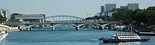
The Pont d'Austerlitz is a bridge which crosses the Seine River in Paris, France. It owes its name to the battle of Austerlitz (1805).
Location
The bridge links the 12th arrondissement at the rue Ledru-Rollin, to the 5th and 13th arrondissements, at the Jardin des Plantes.
History
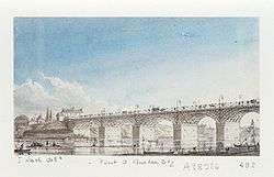
The construction of the bridge came from a necessity to link the Faubourg Saint-Antoine on the right bank to the Jardin des Plantes on the left bank. At the beginning of the 19th century the first bridge was constructed. In 1801, the engineer Becquey de Beaupré proposed a five-arched bridge. In 1854, the bridge was judged dangerous and the width was increased to 18 meters (59 feet) and finally to 30 meters (98 feet).
Characteristics

View from the Pont de Sully
- Type : Arch bridge
- Construction : 1801–1805, 1854 and 1884–1885
- Inauguration : 1854 and 1885
- Architects : Alexandre Michal, Jules Savarin (1854) – Jean-Marie-Georges Choquet (1885)
- Material : Stone Masonry
- Total Length : 173,80 m
Access

Location on the Seine
| Located near the Métro station: Quai de la Rapée. |
See also
| Wikimedia Commons has media related to Pont d'Austerlitz. |
This article is issued from Wikipedia - version of the 6/29/2016. The text is available under the Creative Commons Attribution/Share Alike but additional terms may apply for the media files.