Pondaurat
| Pondaurat | |
|---|---|
|
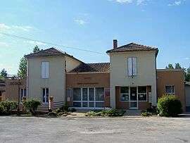
Town hall | |
 Pondaurat | |
|
Location within Nouvelle-Aquitaine region  Pondaurat | |
| Coordinates: 44°32′15″N 0°05′13″W / 44.5375°N 0.0869°WCoordinates: 44°32′15″N 0°05′13″W / 44.5375°N 0.0869°W | |
| Country | France |
| Region | Nouvelle-Aquitaine |
| Department | Gironde |
| Arrondissement | Langon |
| Canton | Auros |
| Intercommunality | Pays d'Auros |
| Government | |
| • Mayor (2008–2014) | Francis Zaghet |
| Area1 | 8.74 km2 (3.37 sq mi) |
| Population (2008)2 | 372 |
| • Density | 43/km2 (110/sq mi) |
| Time zone | CET (UTC+1) |
| • Summer (DST) | CEST (UTC+2) |
| INSEE/Postal code | 33331 / 33190 |
| Elevation | 11–67 m (36–220 ft) |
|
1 French Land Register data, which excludes lakes, ponds, glaciers > 1 km² (0.386 sq mi or 247 acres) and river estuaries. 2 Population without double counting: residents of multiple communes (e.g., students and military personnel) only counted once. | |
Pondaurat is a commune in the Gironde department in Nouvelle-Aquitaine in southwestern France.
Population
| Historical population | ||
|---|---|---|
| Year | Pop. | ±% |
| 1962 | 397 | — |
| 1968 | 465 | +17.1% |
| 1975 | 380 | −18.3% |
| 1982 | 361 | −5.0% |
| 1990 | 361 | +0.0% |
| 1999 | 355 | −1.7% |
| 2008 | 372 | +4.8% |
See also
References
| Wikimedia Commons has media related to Pondaurat. |
This article is issued from Wikipedia - version of the 11/9/2016. The text is available under the Creative Commons Attribution/Share Alike but additional terms may apply for the media files.