Poncha Pass
| Poncha Pass | |
|---|---|
|
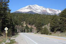
Looking west at Mount Ouray from the north side of Poncha Pass before the highway curves north. | |
| Elevation | 9,010 ft (2,746 m) |
| Traversed by | U.S. Highway 285 |
| Location | Chaffee / Saguache counties, Colorado, United States |
| Coordinates | 38°25′20″N 106°05′13″W / 38.42222°N 106.08694°W |
| Topo map | USGS Poncha Pass |
Poncha Pass (9,010 ft/2,745 m) is a mountain pass in South-Central Colorado (USA). It lies between the San Luis Valley to the south and the valley of the Arkansas River to the north, and is one of the lowest mountain passes in the state.[1] It is in the saddle between the Sangre de Cristo Range, lying to the southeast, and the Sawatch Range, lying to the west and northwest. U.S. Highway 285 runs over the pass, linking the towns of Alamosa to the south and Salida to the northeast. The small town of Poncha Springs lies about 6 miles (9 km) north of the pass. The pass has a mild approach on the northern side and a moderate 5% approach from the south, though it remains open all year round and does not normally cause problems for vehicles in winter.
Poncha Pass lies on the border between Chaffee County and Saguache County, and on the border between the San Isabel National Forest and the Rio Grande National Forest.
References
- ↑ CyclePass.com - Alphabetical table of Colorado passes, by Michael Fiebach. Retrieved 23 September 2006.
External links
Coordinates: 38°25′20″N 106°05′11″W / 38.4222°N 106.0864°W