Pomona, New York
| Pomona, New York | |
|---|---|
| Village | |
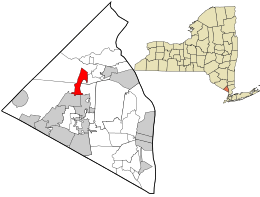 Location in Rockland County and the state of New York. | |
 Pomona, New York Location within the state of New York | |
| Coordinates: 41°11′11″N 74°3′20″W / 41.18639°N 74.05556°WCoordinates: 41°11′11″N 74°3′20″W / 41.18639°N 74.05556°W | |
| Country | United States |
| State | New York |
| County | Rockland |
| Incorporated | February 3, 1967 |
| Government | |
| • Mayor | Brett L. Yagel |
| Area | |
| • Total | 2.4 sq mi (6.3 km2) |
| • Land | 2.4 sq mi (6.3 km2) |
| • Water | 0.0 sq mi (0.0 km2) |
| Elevation | 453 ft (138 m) |
| Population (2010) | |
| • Total | 3,103 |
| • Density | 1,300/sq mi (490/km2) |
| Time zone | Eastern (EST) (UTC-5) |
| • Summer (DST) | EDT (UTC-4) |
| ZIP code | 10970 |
| Area code(s) | 845 |
| FIPS code | 36-58992 |
| GNIS feature ID | 0960875 |
| Website | http://www.pomonavillage.com/ |
Pomona is a village partly in the town of Ramapo and partly in the town of Haverstraw in Rockland County, New York, United States. It is located north of New Hempstead, east of Harriman State Park, north of Monsey and west of Mount Ivy. According to the 2010 Census, the population was 3,103, a 13 percent increase from the 2000 figure of 2,726.
The current mayor is Brett Yagel.
History
The village of Pomona was incorporated February 3, 1967, within the towns of Ramapo and Haverstraw. Actor Burgess Meredith provided the seed money for the incorporation.[1] Pomona was named after the goddess of fruit trees, gardens, and orchards, for the area's many apple orchards.
Geography
Pomona is located at 41°11′11″N 74°3′20″W / 41.18639°N 74.05556°W (41.186504, -74.055417).[2]
According to the United States Census Bureau, the village has a total area of 2.4 square miles (6.2 km2), 1.4 square miles (3.6 km2) of which is in the town of Haverstraw and 1.0 sq mi (2.6 km2) of which is in the town of Ramapo. All of Pomona's total area is land.
Demographics
| Historical population | |||
|---|---|---|---|
| Census | Pop. | %± | |
| 1970 | 1,792 | — | |
| 1980 | 2,421 | 35.1% | |
| 1990 | 2,611 | 7.8% | |
| 2000 | 2,726 | 4.4% | |
| 2010 | 3,103 | 13.8% | |
| Est. 2015 | 3,234 | [3] | 4.2% |
As of the census[5] of 2010, there were 3,103 people, 1,011 households, and 863 families residing in the village. The population density was 1,292.92 people per square mile (492.54/km²). There were 1,054 housing units at an average density of 439.17 per square mile (167.3/km²). The racial makeup of the village was 66.0% White, 19.1% African American, 0.2% Native American, 9.3% Asian, 2.2% from other races, and 3.2% from two or more races. Hispanic or Latino of any race were 7.1% of the population.
There were 1,011 households out of which 32.7% had children under the age of 18 living with them, 75.6% were married couples living together, 6.6% had a female householder with no husband present, and 14.6% were non-families. 10.7% of all households were made up of individuals and 3.6% had someone living alone who was 65 years of age or older. The average household size was 3.01 and the average family size was 3.22.
In the village the population was spread out with 24.2% age 19 and under, 4.4% from 20 to 24, 20.6% from 25 to 44, 35.0% from 45 to 64, and 15.9% who were 65 years of age or older. The median age was 45.5 years. For every 100 females there were 99.2 males. For every 100 females age 18 and over, there were 97.8 males.
The median income for a household in the village was $103,608, and the median income for a family was $108,399. Males had a median income of $72,857 versus $48,958 for females. The per capita income for the village was $43,946. About 1.5% of families and 2.0% of the population were below the poverty line, including 1.1% of those under age 18 and 7.1% of those age 65 or over.
Historical markers
- Ladentown United Methodist Church, 14 Ladentown Road (NRHP).
- The Pig Knoll School, 584 Route 306 - currently the Pomona Cultural Center.
Landmarks and places of interest
- Pomona Cultural Center, 584 Route 306, Pomona NY 10970
- Palisades Credit Union Park (formerly named Provident Bank Park)
Parks
- Burgess Meredith
- Secor
- Van den Hende
References
- ↑ http://www.pomonavillage.com/burgesspark.html
- ↑ "US Gazetteer files: 2010, 2000, and 1990". United States Census Bureau. 2011-02-12. Retrieved 2011-04-23.
- ↑ "Annual Estimates of the Resident Population for Incorporated Places: April 1, 2010 to July 1, 2015". Retrieved July 2, 2016.
- ↑ "Census of Population and Housing". Census.gov. Retrieved June 4, 2015.
- ↑ "American FactFinder". United States Census Bureau. Retrieved 2008-01-31.
External links
Municipalities and communities of Rockland County, New York, United States | ||
|---|---|---|
| Towns | 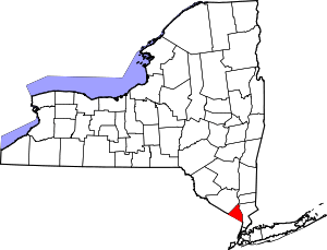 | |
| Villages | ||
| CDPs | ||
| Other hamlets | ||