Polesie Voivodeship
| Polesie Voivodeship Województwo poleskie | |||||
| Voivodeship of Poland | |||||
| |||||
|
Coat of arms | |||||
.svg.png) | |||||
| Capital | Pińsk (until August 1921) Brześć | ||||
| Voivode | |||||
| • | 1921–1922 (first) | Walery Roman | |||
| • | 1932–1939 (last) | Wacław Kostek-Biernacki | |||
| Historical era | Interwar period | ||||
| • | Established | 12 February 1921 | |||
| • | Soviet invasion | September 1939 | |||
| Area | |||||
| • | 1921 | 42,280 km2 (16,324 sq mi) | |||
| • | 1939 | 36,668 km2 (14,158 sq mi) | |||
| Population | |||||
| • | 1921 | 880,898 | |||
| Density | 20.8 /km2 (54 /sq mi) | ||||
| • | 1931 | 1,132,200 | |||
| Political subdivisions | 27 / [#Cities and counties | ||||
| Today part of | Ukraine, Belarus | ||||

Polesie Voivodeship (Polish: województwo poleskie) was an administrative unit of interwar Poland (1918–1939). It ceased to function in September 1939, following the Nazi-German and Soviet invasion of Poland.
Demographics
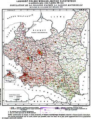
The provincial capital of the Polesie Voivodeship, and also the largest city was Brześć nad Bugiem (Brest-on-the-Bug) with some 48,000 inhabitants (1931). The province was made up of 9 powiats (counties), and had 12 substantial towns or cities. In 1921, the population of the province numbered 879,417, with the population density of about 20.8 persons per km², the lowest in interwar Poland. By 1931, thanks to a government-sponsored settlement programme and the progressive development of education, commerce and industry in the urban centres (neglected under the Tsarist Russia), the population had risen to 1,132,200, and the population density to 31 per km². The Jews constituted 49.2% of the urban population of Polesie, the highest in interwar Poland. They engaged mainly in retail trade, commerce and small industry.[1]
According to the 1931 census, some 80.6% of the population engaged in agriculture. Most estates above 50 hectares in size, were owned by the Poles (65.4%) followed by ethnic Belarusians (17.8%).[1] The majority of inhabitants (62.6%) described themselves merely as “locals” (tutejsi), and for the greater part were peasants of Belarusian and Ukrainian origin. Ethnic Poles made up around 15% of the population, Ukrainians (mainly in the south-east) numbered about 5%, Belarusians 6.6%, and Jews (mainly in towns) around 10%. Smaller communities of Russians also existed. The illiteracy rate was 48.4% due to the lingering imperial legacy, the highest in Poland and well above national average of 23.1% (in 1931).
Location and area
Initially, the area of the voivodeship comprised 42 149 km². However, in 1930 Sarny county became part of the Volhynian Voivodeship, thus the area shrank to 36 668 square kilometers. Even after this change, it still was the biggest Voivodeship of interwar Poland.
Polesie lay in eastern part of the then Polish state, bordering the Soviet Union to the east, Lublin Voivodeship and Białystok Voivodeship (1919–1939) to the west, Nowogródek Voivodeship to the north and the Volhynian Voivodeship to the south. Most of it consisted of the Polesie swamp - a flat, vast, sparsely inhabited area, with several rivers and streams. Access to some villages and hamlets required boats, especially in early spring, when the waters of the Pripyat and other rivers (like the Pina, the Styr and the Horyn) rose as the snow melted. In 1937 forests covered 33.3% of the Voivodeship (compared with the average for the whole country of 22.2%). The biggest lake in the voivodeship's area, Lake Wygonowskie, lay on the Oginski Canal. In spring of 1939, construction of the 127-kilometer Stone Canal (Kanal Kamienny) began. The canal was planned to connect Pinsk with Klesow, which at that time was part of Volhynian Sarny County.
Cities and counties
Brześć, the voivodeship’s capital and biggest city, did not have an impressively large population: about 50,700 according to the 1931 national census and around 55,000 in mid-1939. Other urban centers included Pińsk (population 31,900 in 1931), Dawidgródek (population 11,500), Kobryń (population 10,100) and Prużana (population 6,500).
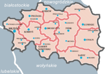
Counties of Polesie Voivodeship
- Brześć county (area 4625 km², pop. 216 200),
- Drohiczyn Poleski county (area 2351 km², pop. 97 000),
- Iwacewicze county (area 3562 km², pop. 83 700),
- Kamień Koszyrski county (area 3243 km², pop. 95 000),
- Kobryń county (area 3545 km², pop. 114 000),
- Łuniniec county (area 5722 km², pop. 109 300),
- Pińsk county (area 5587 km², pop. 183 600),
- Prużana county (area 2644 km², pop. 108 600),
- Stolin county (area 5389 km², pop. 124 800).
The voivodeship was created on February 19, 1921 with its capital was Pińsk.[2] However, after the citywide fire in August 1921, the voivodship's capital was moved to Brześć Litewski. Brześć Litewski was renamed as Brześć nad Bugiem ("Brest on the Bug" in Polish) on March 20, 1923.[3] Between 1921 and 1923 the first administrative division of Polesie Voivodeship included: the Brześć county, the Drohiczyn Poleski county, the Kamień Koszyrski county, the Kossów county, the Łuniniec county, the Pińsk county, the Prużana county, and the Sarny county.
On January 1, 1923, Stolin county (powiat) was created from several gminas within the Łuniniec, Pińsk and Sarny counties.[4] On December 16, 1930, Sarny County was transferred to Wołyń Voivodeship.[5] On April 1, 1935, Kossów county's capital was moved to Iwacewicze and it was renamed as Iwacewicze county.[6]
Infrastructure and industry
Polesie was the largest voivodeship of interwar Poland, comprising 10 percent of the country's overall territory with an area of 42,280 square kilometres (16,320 sq mi).[7] However, the Russian rule during the Partitions of Poland (ending in 1918), left Polesie in the state of economic collapse. Roads and means of communication were destroyed, along with most of industry. Agriculture was underdeveloped. There were few rail hubs: Brześć (with 5 routes), Łuniniec, Żabinka, and Sarny. By 1937 the total length of railroads within voivodeship grew to 1,063 km, while rail density was 2.9 km per 100 km² (the lowest in the country). The number of people employed in trades was 38,400 in 12,800 enterprises.[8] Improvements in the socio-economic situation of the ethnically Belarusian peasantry were very slow. Statistically, ethnic Poles constituted 14,5% of general population in 1931; Polish Jews, about 10,1% (or 114,000) half of whom (at roughly 49%) lived in the cities. Most of provincial economy depended upon the Jewish tradesmen,[7] many of whom immigrated to Poland to escape pogroms in the east.[9][10] Ethnic Ukrainian population of Polesie was 19,3% of the voivodeship, at 219,000.[11] Persisting needs of continuous state investment (as outlined in the 1936 memo) were massive; the road-building programme required 7.1 million Polish złoty annually, with the complete lack of stone in the area. The projected cost of reconstructing waterways was estimated at 14.4 million złoty; processing plants and points of sales at 2.5 million złoty, dairy industry at 480.000 złoty annually, including 2 million złoty for education. In the opinion of local administrators, the economy of interwar Poland consisted of two parts: Poland "A" (better developed) and Poland "B" (less developed); the Polesie area was named by them Poland "C".[8]
1939 and its aftermath
Two and a half weeks after the German invasion of Poland, the Soviet forces invaded eastern Poland on September 17, 1939, in accordance with the secret Molotov-Ribbentrop Pact signed in August 1939. As the bulk of the Polish Army had concentrated in the west of the country to fight the Germans, the Soviets met with little resistance and their troops quickly moved westwards until they reached Brześć where they met up with the German army, and held the joint victory parade.[12]
The Soviet authorities who occupied Polesie Voivodeship dismantled the Polish administration and formally annexed what became known as West Belarus into the Soviet Union, dividing it between the Ukrainian Soviet Socialist Republic and the Byelorussian Soviet Socialist Republic (Polesia Voblast). Following the Tehran Conference of 1943, Joseph Stalin insisted in 1945 on redrawing Poland's borders with Western approval. The Soviets forcibly resettled the Polish population of the province to the west, and the prewar voivodeship area became part of the Soviet Union for the next sixty years. As of 2009 most of the former Polesie Voivodeship (including Brześć and Pińsk) belongs to the sovereign Belarus; only the southern part of it belongs to Ukraine (Kamień Koszyrski and Sarny).[1][13][14] Nearly all of Belarusian part of Polesie Voivodeship is part of Brest Voblast, except Sosnkowicze (now Lenin) gmina of Łuniniec powiat with villages of Cimoszewicze ve Milewicze, it was part of Pinsk Oblast between 1939 and 1941 and 1944 and 1954 and Brest Voblast between 1954 and 1960 as a raion (Its center was moved to Mikashevichy in 8 June) before transferring to Žytkavičy Rajon of Homiel Voblast due to dissolving Lenin one in 20 January 1960.
Voivodes
- Walery Roman 14 March 1921 – 3 May 1922
- Stanisław Józef Downarowicz 18 May 1922 – 2 October 1924
- Kazimierz Młodzianowski 4 October 1924 – 5 May 1926
- Vacant 5 May 1926 – 14 July 1926
- Jan Krahelski 14 July 1926 – 8 September 1932 (acting to 23 December 1926)
- Wacław Kostek-Biernacki 8 September 1932 – 2 September 1939
- Jerzy Albin de Tramecourt 17 February 1937 – 7 September 1937 (acting for Kostek-Biernacki)
See also
- Brest Voblast, today Belarus
Notes
- 1 2 3 Alice Teichova, Herbert Matis, Jaroslav Pátek (2000). Economic Change and the National Question in Twentieth-century Europe. Cambridge University Press. pp. 342–344. ISBN 978-0-521-63037-5.
- ↑ http://isap.sejm.gov.pl/DetailsServlet?id=WMP19210550097
- ↑ http://isap.sejm.gov.pl/DetailsServlet?id=WMP19230650070
- ↑ http://isap.sejm.gov.pl/Download?id=WDU19221161051&type=2
- ↑ http://isap.sejm.gov.pl/Download;jsessionid=A5746B836034D2EE5E95883B3606CC7D?id=WDU19300820649&type=2
- ↑ http://isap.sejm.gov.pl/Download?id=WDU19311110867&type=2
- 1 2 Informator Przemysłu, Handlu, Rolnictwa, Rzemiosł, Szkolnictwa, Miernictwa i inn. Województw: Lubelskiego, Kieleckiego, Wołyńskiego, Poleskiego, Białostockiego i Nowogródzkiego (1935), Województwo Poleskie, C. Sołowiejczyk, Grodno, 1935.
- 1 2 Memoriał wręczony w dniu 17.XII.1936 roku Prezesowi Rady Ministrów [Report delivered to Prime Minister] (1937), Gospodarcze i kulturalne potrzeby województwa Poleskiego, Nakładem Towarzystwa Rozwoju Ziem Wschodnich Warszawa, 1937
- ↑ Norman Davies, God's Playground (Polish edition), Second volume, pp. 512–513.
- ↑ Alice Teichova, Herbert Matis, Jaroslav Pátek (2000). Economic Change and the National Question in Twentieth-century Europe. Cambridge University Press. pp. 342–344. ISBN 978-0-521-63037-5.
- ↑ Prof. Wojciech Śleszyński, Kresy II RP w obliczu drugiej wojny światowej, Wydział Historyczno-Socjologiczny Uniwersytetu w Białymstoku
- ↑ Janusz Magnuski, Maksym Kolomijec, Czerwony Blitzkrieg. Wrzesien 1939: Sowieckie Wojska Pancerne w Polsce (The Red Blitzkrieg. September 1939: Soviet armored troops in Poland). Wydawnictwo Pelta, Warszawa 1994, ISBN 83-85314-03-2, Scan of book page 72.
- ↑ Norman Davies, God's Playground (Polish edition), Second volume, p.512-513
- ↑ Stosunki polsko-białoruskie pod okupacją sowiecką, (Polish-Belarusian relations under the Soviet occupation). Bialorus.pl (Polish)
References
- (Polish) Mały rocznik statystyczny 1939, Warszawa, Nakładem Głównego Urzędu Statystycznego Rzeczpospolitej Polskiej (Concise Statistical Year-Book of Poland, Warsaw 1939)
| City Voivodeship |  | |
|---|---|---|
| Land Voivodeships | ||
| Planned Voivodeships | ||
Coordinates: 52°07′06″N 26°05′46″E / 52.118248°N 26.096223°E