Pointe des Châteaux (Guadeloupe)
 A sight of la Pointe des Châteaux | |
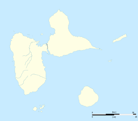 Pointe des Châteaux Location within Guadeloupe | |
| Geography | |
|---|---|
| Location | Caribbean |
| Coordinates | 16°14′40″N 61°10′36″W / 16.24444°N 61.17667°WCoordinates: 16°14′40″N 61°10′36″W / 16.24444°N 61.17667°W |
| Adjacent bodies of water | Atlantic Ocean, Caribbean Sea |
| Administration | |
| Region |
|
| Town | Saint-François |
La Pointe des Châteaux (en: Castles headland) is a peninsula that extends into the Atlantic Ocean from the Eastern coast of the island of Grande-Terre, in Guadeloupe.

Located 11 km East from Saint-François (the commune it is administratively attached to), it overlooks the island of La Désirade (a dependency of Guadeloupe), eructing only 8 km away into the Atlantic.
Made of distinctive rock formations and a large littoral strip, La Pointe des Châteaux hosts rare fauna and flora species, some of which being indigenous to the site.
A dramatic place of crashing waves and strong winds, La Pointe des Châteaux stands as a popular tourist destination, attracting an average of 500,000 visitors every year.
La Plage des Grandes Salines
Northwest to the Pointe des Châteaux's clifftop, lies the long but dangerous beach of les Grandes Salines : a popular spot for kite flying, thanks to its strong and steady trade winds. Sea conditions off the beach tending to be rough most of the time and the bottom dropping away relatively quickly, Grandes Salines is not suited for relaxed swimming, but remains sought-after for more extreme water sports and bay watchers.
Photo Gallery
 Cross at the very clifftop of the Pointe des Châteaux.
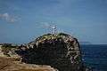 Cross at the Pointe des Châteaux and La Désirade out far.
 A far view of La Désirade from the Pointe des Châteaux.
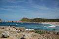 Pointe des Châteaux, Guadeloupe.
 The long beach of "Grandes Salines" at Pointe des Châteaux.
 The long beach of "Grandes Salines" at Pointe des Châteaux.
See also
External links
- Office de Tourisme de Saint François – Official site of the Saint-François Tourism Board
- Les Îles de Guadeloupe — Official site of the Guadeloupe Islands Tourism Board
| Wikimedia Commons has media related to Pointe des Châteaux. |
Guadeloupe articles | |||
|---|---|---|---|
| History | |||
| Geography | |||
| Politics |
| ||
| Economy | |||
| Culture |
| ||
| |||