Poindimié
| Poindimié | |
|---|---|
|
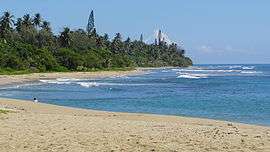
Poindimié Beach | |
 Location of the commune (in red) within New Caledonia | |
| Coordinates: 20°56′59″S 165°19′45″E / 20.9496°S 165.3293°ECoordinates: 20°56′59″S 165°19′45″E / 20.9496°S 165.3293°E | |
| Country | France |
| Sui generis collectivity | New Caledonia |
| Province | North Province |
| Government | |
| • Mayor | Paul Néaoutyine |
| Area1 | 673.1 km2 (259.9 sq mi) |
| Population (2014 census)2 | 4,868 |
| • Density | 7.2/km2 (19/sq mi) |
| Ethnic distribution | |
| • 1996 census |
Kanaks 82.2% Europeans 13.1% Polynesians 0.9% Other 3.8% |
| INSEE/Postal code | 98822 / 98822 |
| Elevation |
0–1,385 m (0–4,544 ft) (avg. 10 m or 33 ft) |
|
1 New Caledonia Land Register (DITTT) data, which exclude lakes and ponds larger than 1 km² (0.386 sq mi or 247 acres) as well as the estuaries of rivers. 2 Population without double counting: residents of multiple communes (e.g., students and military personnel) only counted once. | |
Poindimié is a commune in the North Province of New Caledonia, an overseas territory of France in the Pacific Ocean.
Climate
| Climate data for Ponerihouen | |||||||||||||
|---|---|---|---|---|---|---|---|---|---|---|---|---|---|
| Month | Jan | Feb | Mar | Apr | May | Jun | Jul | Aug | Sep | Oct | Nov | Dec | Year |
| Average high °C (°F) | 28 (82) |
28 (83) |
28 (82) |
27 (80) |
26 (78) |
24 (75) |
23 (74) |
23 (74) |
24 (75) |
25 (77) |
26 (79) |
27 (81) |
26 (78) |
| Average low °C (°F) | 23 (74) |
24 (75) |
23 (74) |
22 (72) |
21 (69) |
19 (66) |
18 (65) |
18 (64) |
18 (65) |
20 (68) |
21 (70) |
22 (72) |
21 (70) |
| Average precipitation mm (inches) | 368 (14.5) |
315 (12.4) |
396 (15.6) |
230 (9) |
150 (6) |
211 (8.3) |
145 (5.7) |
99 (3.9) |
97 (3.8) |
114 (4.5) |
191 (7.5) |
198 (7.8) |
2,510 (99) |
| Source: Weatherbase [1] | |||||||||||||
References
- ↑ "Weatherbase: Historical Weather for Ponerihouen, New Caledonia". Weatherbase. 2011. Retrieved on November 24, 2011.
| Wikimedia Commons has media related to Poindimié. |
| Provinces | |
|---|---|
| Communes | |
This article is issued from Wikipedia - version of the 9/19/2016. The text is available under the Creative Commons Attribution/Share Alike but additional terms may apply for the media files.