Požeška gora
| Požeška Gora | |
|---|---|
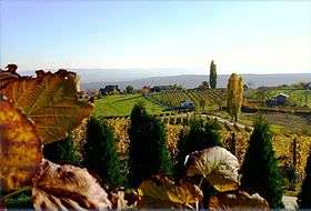 Vineyards on Požeška Gora near Pleternica | |
| Highest point | |
| Elevation | 618 m (2,028 ft) |
| Coordinates | 45°16′55″N 17°34′01″E / 45.28194°N 17.56694°ECoordinates: 45°16′55″N 17°34′01″E / 45.28194°N 17.56694°E |
| Geography | |
 Požeška Gora Location of Požeška Gora in Croatia | |
| Location | Croatia |
Požeška Gora, lit. the Požega Mountain, is a mountain located south of Požega, Croatia in the region of central Slavonia. The mountain is a part of Slavonian mountains enveloping the Požega Valley,[1] located adjacent to Psunj to the east of Požeška Gora, and to the west of Dilj. Požeška Gora and Dilj are separated by a gap through which Orljava River flows south out of the Požega Valley.[2][3] The highest peak of the mountain is Kapavac, 618 metres (2,028 feet) above sea level.[4]
Term Babja Gora is also used to refer to the mountain,[5] although in a strict sense Babja Gora is the western part of Požeška Gora, with Pokotina brook representing the eastern boundary of Babja Gora area. The highest peak of Požeška Gora is located in Babja Gora area.[6]
See also
References
- ↑ Neven Bočić (13 January 2010). "Geomorfologija krša Papuka - kap krša u srcu Slavonije" [Geomorphology of Papuk karst - a drop of karst in the heart of Slavonia]. Croatian Geographic Society. Retrieved 16 May 2012.
- ↑ "O županiji" [About the county] (in Croatian). Požega-Slavonia County Tourist Board. Retrieved 15 May 2012.
- ↑ "Prostorni plan Požeško-slavonske županije" [Spatial plan of the Požega-Slavonia County] (PDF) (in Croatian). Ministry of Construction and Spatial Planning (Croatia). July 2002. Retrieved 15 May 2012.
- ↑ Ostroški, Ljiljana, ed. (December 2015). "Geographical and Meteorological Data". Statistički ljetopis Republike Hrvatske 2015 [Statistical Yearbook of the Republic of Croatia 2015] (PDF). Statistical Yearbook of the Republic of Croatia (in Croatian and English). 47. Zagreb: Croatian Bureau of Statistics. p. 48. ISSN 1333-3305. Retrieved 27 December 2015.
- ↑ "Muzej u loncu" [Museum in a pot] (in Croatian). Museum of the city of Požega. Retrieved 16 May 2012.
- ↑ "Opis trase slavonskog planinarskog puta" [Description of Slavonia hiking trail route]. Mountaineering Association of Slavonia. 23 December 2010. Retrieved 16 May 2012.