Počitelj, Čapljina
| Počitelj Почитељ | |
|---|---|
| Town | |
.jpg) | |
 Location of Čapljina municipality within Bosnia and Herzegovina. | |
| Country | Bosnia and Herzegovina |
| Entity | Federation of Bosnia and Herzegovina |
| Canton | Herzegovina-Neretva |
| Municipality | Čapljina |
| Time zone | CET (UTC+1) |
| • Summer (DST) | CEST (UTC+2) |
| Area code(s) | +387 036 |
Počitelj is a village in the Čapljina municipality in Bosnia and Herzegovina. It is located in the Herzegovina-Neretva Canton in the Federation of Bosnia and Herzegovina. The historic site of Počitelj is located on the left bank of the river Neretva, on the main Mostar to Metković road, and it is about 30 km. to the south of Mostar.
The village is built in a natural karst amphiteatre along the Neretva river. The walled town of Počitelj evolved in the period from the 16th to the 18th centuries. Architecturally, the stone-constructed parts of the town are a fortified complex, in which two stages of evolution are evident: medieval, and Ottoman.[1]
History
The first recorded reference to Počitelj dates from 1444, in charters by the Aragon king Alfonso V of Aragon and in 1448 by Frederick III, Holy Roman Emperor. It was mentioned as a fortified town of the Dubrava district, ruled by Duke Stjepan Vukčič Kosača. In the period between 1463-1471 the town housed a Hungarian garrison and was fortified into a strategic defence stronghold. In 1471, following a brief siege, the town was conquered by the Ottomans. It lost its strategic significance. It remained within the Ottoman Empire until 1878. From 1782 to 1879 Počitelj was the seat of akadiluk (area under the jurisdiction of a qadi, or judge) and the center of the Počitelj military district from 1713 to 1835.
The significance and the town's appearance has altered during the course of its history. As far as the development of Počitelj goes, three significant periods can be distinguished:
- The period of the Hungarian King Matthias Corvinus during which the town had a major strategic importance (1463–1471)
- The period of the settlement development under the Ottoman Empire with the erection of public buildings: mosques, imaret (charitable kitchen), mekteb (Muslim primary school), medresa (Muslim high school), hamam, baths, han (inn) and the sahat-kula (clock-tower) (1471–1698).
- The period after the Venetians conquered and destroyed Gabela (1698–1878), the main Ottoman fortification facing Dalmatia, and recovery of Počitelj's strategic importance.
After the establishment of Austro-Hungarian rule in Bosnia and Herzegovina in 1878, Počitelj lost its strategic importance and started deteriorating rapidly. The population declined gradually. The loss of the town's strategic role assisted in the preservation of the original urban architectural ensemble, so that the town remained in its original form to present day.
The entire historic urban site of Počitelj and surrounding area suffered extensive collateral damage during the 1992-1996 war in Bosnia and Herzegovina. Namely, it was heavily damaged by Croatian forces during the 1993 Bosnian War.[2][3][4] Following the bombing, Počitelj's sixteenth-century master works of Islamic art and architecture were destroyed and a large part of the town's population was displaced.[3][4]
As proposed by the University of York, United Kingdom, and the University of Sarajevo, Počitelj was in 1996 named by the World Monuments Watch as one of the world's 100 most endangered cultural heritage sites. In the year 2000 the Federation of Bosnia and Herzegovina Government initiated the Programme of the permanent protection of Počitelj. The programme includes the protection of cultural heritage from deterioration, restoration of damaged and destroyed buildings, encouraging the return of the refugees and displaced persons to their homes and the long-term protection and revitalization of the Počitelj's historic urban area. The Programme is on-going.[1]
As of 2008, the International Council on Monuments and Sites (ICOMOS) expressed concern over the proposed construction of a nearby highway, Corridor Vc. Initial plans include a 1,000-meter long, 100-meter high bridge over the Neretva river. It is feared that the construction will result in a “physical, visual and ecological degradation and devastation of this cultural and historical unity and its authentic surroundings.” [5] While a new potential location for the bridge crossing is being investigated, non-controversial sections are under construction.[6]
Historic sites
- The Gavrakanpetanović house: built at the end of the 16th century, it was named after and housed the captains of Počitelj, who belonged to the Gavrakanpetanovič family. It is typical example of the residential architecture of the village. It is the only house in town to have separate rooms for men and women. The house became the residence of an artists' colony between 1961 and 1975, one of which was the Italian painter Vittorio Miele. This was the longest operating artist colony in Southeast Europe. During the Bosnian war, the house was set on fire. It was restored in its original state in 2003.
- The Šišman Ibrahim-pašina džamija or Hajji Alija mosque: built in 1563 by Hajji-Alija, son of Musa. It was repaired in the 17th century by Šišman Ibrahim pasha. The locals gave the mosque afterwards his name. The domed mosque is notable for its special acoustics. The mosque was restored in the 1970s, but badly damaged during the Bosnian War in 1993. It was restored again in 2002.
- The Kula, a silo-shaped fort overlooking the village from the top of the hill. It used to house watchmen and military as a guard against possible intrusions from the Neretva valley.
- The Sahat Kula, a bell tower located closer to the river and at the south side of the old town.
Demographics
No up-to-date data currently exists for Počitelj and its demographic profile was significantly altered after the Bosnian war. The last demographics research was conducted in 1991 and its results are as follows:
Population Total: 905[7]
- Muslims - 660 (72.92%)
- Croats - 172 (19.00%)
- Yugoslavs - 36 (3.97%)
- Serbs - 20 (2.20%)
- others and unknown - 17 (1.87%)
Significance
Počitelj represents one of the few urban ensembles in Bosnia and Herzegovina that were preserved in their integrity to the present times. It was also developed through the several phases of the history beginning with the medieval period. Its significant strategic role from the 13th to 17th century gave its inhabitants the power to build one of the most important, and best preserved ensembles within the city walls in the region. The town can be compared with some of the noted world heritage sites as the old towns of Mostar (Bosnia and Herzegovina), Ohrid (Macedonia), Safranbolu (Turkey), Gjirokaster (Albania). Počitelj's layout and use of building materials put it into the group of Ottoman-Mediterranean types of small settlements.[1]
Gallery
-
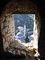
A view of Počitelj from the citadel, October 2007
-
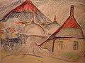
Vittorio Miele, Počitelj
-

Mosque and watch tower, (A view from above)
-

Citadel and mosque
-

Počitelj Tower
References
- 1 2 3 The historic urban site of Počitelj
- ↑ Gort, Jerald (2002). Religion, Conflict and Reconciliation: Multifaith Ideals and Realities. Rodopi. p. 347. ISBN 90-420-1460-1.
- 1 2 Layton, Robert (2001). Destruction and Conservation of Cultural Property. Routledge. p. 171. ISBN 0-415-21695-8.
- 1 2 Sells, Michael (1998). The Bridge Betrayed: Religion and Genocide in Bosnia. University of California Press. p. 103. ISBN 0-520-21662-8.
- ↑ ICOMOS Bosnia-Herzegovina (2008). "Appeal to Save Počitelj". In Christoph Machat, Michael Petzet and John Ziesemer (Eds.), "Heritage at Risk: ICOMOS World Report 2008-2010 on Monuments and Sites in Danger" (PDF).. Berlin: hendrik Bäßler verlag, 2010, pg. 36.
- ↑ Bankwatch Network (18 July 2010). "Report from fact-finding mission on Corridor Vc motorway, Bosnia and Herzegovina, 23–25 February 2010" (PDF). Retrieved 27 May 2011.
- ↑ Official results from the book: Ethnic composition of Bosnia-Herzegovina population, by municipalities and settlements, 1991. census, Zavod za statistiku Bosne i Hercegovine - Bilten no.234, Sarajevo 1991.
| Wikimedia Commons has media related to Počitelj. |
| Countries | 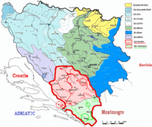 | ||||||
|---|---|---|---|---|---|---|---|
| Places | |||||||
| Tributaries |
| ||||||
| Lakes |
| ||||||
| Related articles | |||||||
Coordinates: 43°08′N 17°44′E / 43.133°N 17.733°E