Pleasanton, Texas
| Pleasanton, Texas | |
|---|---|
| City | |
|
Giant oak tree in Downtown Pleasanton across from "Mr. Cowboy" sculpture | |
 Location of Pleasanton, Texas | |
 | |
| Coordinates: 28°58′1″N 98°29′6″W / 28.96694°N 98.48500°WCoordinates: 28°58′1″N 98°29′6″W / 28.96694°N 98.48500°W | |
| Country |
|
| State |
|
| County | Atascosa |
| Government | |
| • Type | Council-Manager |
| • City Council |
Mayor Clinton J. Powell Douglas Best Abraham Saenz, Jr. Diana K. Prasifka Eliseo Flores Robert Earl Wood Travis Hall |
| • City Manager | Bruce E. Pearson |
| Area | |
| • Total | 7.8 sq mi (20.3 km2) |
| • Land | 7.8 sq mi (20.3 km2) |
| • Water | 0.0 sq mi (0.0 km2) |
| Elevation | 361 ft (110 m) |
| Population (2010) | |
| • Total | 8,934 |
| • Density | 1,141/sq mi (440.5/km2) |
| Time zone | Central (CST) (UTC-6) |
| • Summer (DST) | CDT (UTC-5) |
| ZIP code | 78064 |
| Area code(s) | 830 |
| FIPS code | 48-58280[1] |
| GNIS feature ID | 1375500[2] |
| Website |
www |

Pleasanton is a city in Atascosa County, Texas, United States. The population was 8,934 at the 2010 census.[3] Pleasanton's official motto is "The City of Live Oaks and Friendly Folks." It is part of the San Antonio-New Braunfels Metropolitan Statistical Area.
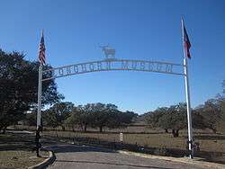
Pleasanton honors its cowboy heritage with the "Mr. Cowboy" sculpture in front of City Hall and across from the giant oak tree downtown. The roots of the cattle kingdom can be traced to Atascosa County in the 1860s, which calls itself "the birthplace of the cowboys." The sculpture is a gift of Ben and Mona Parker. The Longhorn Museum in east Pleasanton on Highway 97 contains artifacts and memorabilia of the cowboy years. The Cowboy Homecoming, begun in 1966, is an annual event held at the Atascosa River Park in Pleasanton.
History
Pleasanton was established in 1858 when conflicts with the Indians caused the settlers to move the location of the county seat from Amphion. The settlers chose the current town site because of its location at the mouth of Bonita Creek. John Bowen (died 1867), San Antonio's first Anglo-American postmaster, founded and named the town of Pleasanton after his good friend and fellow early Texas Settler John Pleasants.
At one time Pleasanton had two newspapers, the Pleasanton Picayune, which became the Pleasanton Express in 1909, and the Pleasanton Reporter. The county seat was relocated from Pleasanton to Jourdanton in 1910. Pleasanton was incorporated in 1917.
Along with San Antonio, Uvalde, Crystal City, Carrizo Springs, and Corpus Christi, Pleasanton was a major stop on the now-defunct San Antonio, Uvalde and Gulf Railroad, which operated from 1909 until it was merged into the Missouri Pacific Railroad in 1956. The rail headquarters was located in a modern two-story depot in North Pleasanton beginning in 1913. However, headquarters closed in 1926, and later the SAU&G, or the Sausage Line as it was called, was merged into the Missouri Pacific. The headquarters depot has been razed, but an earlier depot in Pleasanton is displayed at the Longhorn Museum. The remaining San Antonio-to-Corpus Christi freight line is under the Union Pacific system.[4][5]
In November 1957, the citizens of Pleasanton voted overwhelmingly to desegregate the public schools. This came some two months after the crisis at Little Rock Central High School in Arkansas. Some three dozen African American pupils were then integrated into the Pleasanton school.[6]
Healthcare
Stephen Hill, Harold Barrow and Wayne Schuchart owned and operated South Texas Regional Medical Center, in the neighboring city of Jourdanton, prior to the sale of the healthcare facility to Community Health Systems in November 2001. South Texas Regional Medical Center is the only hospital in Atascosa County.
Geography and climate
Pleasanton is located at 28°58′1″N 98°29′6″W / 28.96694°N 98.48500°W (28.966953, -98.484937),[7] about 35 miles (56 km) south of downtown San Antonio, 110 miles (180 km) south-southwest of Austin and 110 miles (180 km) north by north-northwest of Corpus Christi.
According to the United States Census Bureau, the city has a total area of 7.8 square miles (20.3 km2), all land.[3] The elevation at the center of Pleasanton is 360 feet (110 m) above sea level.
The average annual temperature of Pleasanton is 70 °F (21 °C). The mean temperature on January 1 is 50 °F (10 °C) and on June 1 is 78 °F (26 °C). Average annual precipitation is 26.1 inches (660 mm).
Most soils of Pleasanton are quite sandy at the surface but have a clay-rich subsoil which holds moisture. They belong to the Alfisol soil order. Common soil series in town are Nusil, Poth and Rhymes.[8]
Demographics
| Historical population | |||
|---|---|---|---|
| Census | Pop. | %± | |
| 1870 | 206 | — | |
| 1880 | 393 | 90.8% | |
| 1890 | 367 | −6.6% | |
| 1920 | 1,036 | — | |
| 1930 | 1,154 | 11.4% | |
| 1940 | 2,074 | 79.7% | |
| 1950 | 2,913 | 40.5% | |
| 1960 | 3,467 | 19.0% | |
| 1970 | 5,407 | 56.0% | |
| 1980 | 6,346 | 17.4% | |
| 1990 | 7,678 | 21.0% | |
| 2000 | 8,266 | 7.7% | |
| 2010 | 8,934 | 8.1% | |
| Est. 2015 | 9,829 | [9] | 10.0% |
As of the census[1] of 2000, there were 8,266 people, 2,941 households, and 2,135 families residing in the city. The population density was 1,293.5 people per square mile (499.5/km²). There were 3,212 housing units at an average density of 502.6 per square mile (194.1/km²). The racial makeup of the city was 79.13% White, 0.98% African American, 0.97% Native American, 0.50% Asian, 0.17% Pacific Islander, 15.34% from other races, and 2.92% from two or more races. Hispanic or Latino of any race were 51.15% of the population.
There were 2,941 households out of which 39.0% had children under the age of 18 living with them, 52.8% were married couples living together, 15.0% had a female householder with no husband present, and 27.4% were non-families. 23.7% of all households were made up of individuals and 11.7% had someone living alone who was 65 years of age or older. The average household size was 2.77 and the average family size was 3.28.
In the city the population was spread out with 30.4% under the age of 18, 9.0% from 18 to 24, 27.1% from 25 to 44, 19.9% from 45 to 64, and 13.6% who were 65 years of age or older. The median age was 33 years. For every 100 females there were 90.7 males. For every 100 females age 18 and over, there were 87.2 males.
The median income for a household in the city was $29,644, and the median income for a family was $34,718. Males had a median income of $28,849 versus $20,144 for females. The per capita income for the city was $14,878. About 16.8% of families and 22.2% of the population were below the poverty line, including 30.9% of those under age 18 and 21.8% of those age 65 or over.
Culture
Part of the film The Sugarland Express was filmed around the intersection of 2nd Street and Commerce Street. Every year, Pleasanton hosts the "Cowboy Homecoming Festival", which commemorates the time when the cowboys driving cattle from South Texas to the rail heads up north would return home. This event takes place each October.
Education
Almost all of Pleasanton is located within the Pleasanton Independent School District and home to the Pleasanton High School Eagles. In the school year 2010-2011 Pleasanton I.S.D. received Academically Unacceptable ratings from the Texas Education Agency for their High School Campus and their School of Choice. The School District received an Acceptable rating for their Jr. High and Exceptional for the Elementary and Primary Campuses. Pleasanton I.S.D. has seen a number of families move their students to Jourdanton I.S.D. and McMullen County I.S.D. due to the poor ratings of the High School Campus.
A small portion of the town is in the Jourdanton Independent School District.
Coastal Bend College of Beeville maintains a branch two-year campus in Pleasanton.
Notable person
- Willie Nelson was a radio DJ in Pleasanton at one time.[11]
Gallery

A view of downtown Pleasanton near the intersection of U.S. Highway 281 south and Farm to Market Road 3350 west 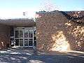
Pleasanton City Hall is located across from the great oak tree downtown. 
The Pleasanton Express office is located next to City Hall. 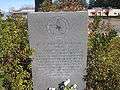
Deputy Sheriffs Thomas Monse, Jr., and Mark Stephenson and state police trooper Terry Wayne Miller are commemorated in a marker in Pleasanton. The three were killed in the line of duty on October 12, 1999. 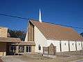
First Baptist Church of Pleasanton was founded by seven charter members in 1866. The congregation originally met in the courthouse when it was located in Pleasanton. 
The Old Rock Schoolhouse, built of locally procured red sandstone, housed the First Baptist Church (located next door) from 1875-1883. 
First United Methodist Church in downtown Pleasanton was founded in 1857 by circuit riders, a year before Pleasanton was established. 
St. Andrew's Catholic Church in Pleasanton 
Covered wagon sign attracts motorists off Highway 97 to the Longhorn Museum in Pleasanton. 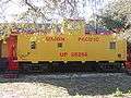
Union Pacific rail car at Longhorn Museum 
The Pleasanton High School Eagles play football in Eagle Stadium. 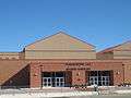
Modern sports complex for Pleasanton Independent School District, located across from Eagles Stadium 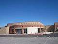
Performing Arts Center of Pleasanton public schools 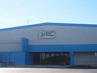
Coastal Bend College of Beeville operates a branch campus in Pleasanton.
References
- 1 2 "American FactFinder". United States Census Bureau. Retrieved 2008-01-31.
- ↑ "US Board on Geographic Names". United States Geological Survey. 2007-10-25. Retrieved 2008-01-31.
- 1 2 "Geographic Identifiers: 2010 Demographic Profile Data (G001): Pleasanton city, Texas". U.S. Census Bureau, American Factfinder. Retrieved August 23, 2013.
- ↑ "Nancy Beck Young, "San Antonio, Uvalde and Gulf Railroad Company"". Texas State Historical Association on-line. Retrieved April 28, 2013.
- ↑ "Hugh Hemphill, "San Antonio Uvalde and Gulf Railroad"". txtransportationmuseum.org. Retrieved April 28, 2013.
- ↑ Civil Rights Chronicles, p. 158
- ↑ "US Gazetteer files: 2010, 2000, and 1990". United States Census Bureau. 2011-02-12. Retrieved 2011-04-23.
- ↑ websoilsurvey.nrcs.usda.gov
- ↑ "Annual Estimates of the Resident Population for Incorporated Places: April 1, 2010 to July 1, 2015". Retrieved July 2, 2016.
- ↑ "Census of Population and Housing". Census.gov. Retrieved June 4, 2015.
- ↑ Houston Music - Willie Nelson: One Hell of a Ride
External links
- City of Pleasanton official website
- The Pleasanton Express, local newspaper
- Handbook of Texas Online article
Municipalities and communities of Atascosa County, Texas, United States | ||
|---|---|---|
| Cities |  | |
| Town | ||
| CDP | ||
| Other unincorporated communities | ||
| Footnotes | ‡This populated place also has portions in an adjacent county or counties | |