Playa del Rey, Los Angeles
| Playa del Rey | |
|---|---|
| Neighborhood of Los Angeles | |
 | |
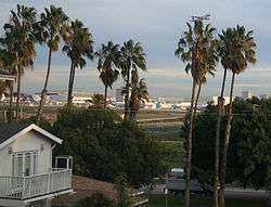
 Playa del Rey Location within Southern Los Angeles | |
| Coordinates: 33°57′32″N 118°26′54″W / 33.958926°N 118.448436°W | |
| Country | United States |
| State | California |
| County | Los Angeles |
| City | Los Angeles |
Playa del Rey (Spanish for "Beach of the King" or "King's beach") is a beachside community in the Westside of the city of Los Angeles, California. It has a ZIP code of 90293 and area codes of 310 and 424. As of 2014, Playa del Rey (zip 90293)'s population is 12,129 people. Since 2000, it has had a population growth of 14.61 percent.[1]
Geography
Playa del Rey is a coastal neighborhood and a district of City of Los Angeles. The rolling hills are the result of ancient, wind-blown, compacted sand dunes which rise up to 125 feet above sea level originally called and often referred to as The Del Rey Hills or "The Bluffs". These dunes run parallel to the coast line, from Playa del Rey, all the way south to Palos Verdes.
The community is bordered by the Pacific Ocean to the west, Marina del Rey and Ballona Creek [2] to the north, Ballona Wetlands and Playa Vista to the northeast, Westchester to the east, Los Angeles International Airport and El Segundo to the south.
History


The northern part was originally wetlands, but the natural flooding was halted by the concrete channel which contains Ballona Creek.
In the 1870s, Playa Del Rey was the location of the first attempt at a dredged harbor in Santa Monica Bay. Under contract with the Atchison, Topeka & Santa Fe Railroad, Moye Wicks' syndicate spent $300,000 to dredge "Port Ballona Harbor", for shipping to the Orient. Within three years, winter waves brought flooding, but what remained of man's early efforts became the Playa Del Rey Lagoon, now a regional public park.
Palisades del Rey (also, Palisades Del Rey) was the name of the original 1921 neighborhood land development by Dickinson & Gillespie Co. that later came to be called Playa del Rey. The company advertised this area of sand dunes as the last stretch of coastal land in the city of Los Angeles to be developed.[3] All of the houses in this area were custom built, many as beach homes owned by Hollywood actors and producers, including Cecil B. Demille, Charles Bickford, and others.
Construction in Playa del Rey surged in 1928 with the development of the Del Rey Hills neighborhood in the Eastern part of the community (to the East of Pershing Drive), and the move of Loyola University (now Loyola Marymount University) to the adjacent community of Westchester.
The southern portion of the original Playa del Rey development, which came to be known as "Surfridge," is now vacant. Between 1966 and 1975 the houses that were once there were either moved or demolished to facilitate the expansion of Los Angeles International Airport (LAX) and to address concerns about the noise of increasing jet plane traffic. The noise from the flights made it less desirable to live on the dunes above the ocean under the LAX flight path. The City of Los Angeles condemned the southern section of Playa del Rey under the power of eminent domain, and purchased all of the homes.[4] Today one can see only barbed-wire fences protecting vacant land and old streets where houses once sat. Recent LAX rejuvenation plans call for the city to finally remove the old streets that still line the empty neighborhood. The condemned areas of the community are now a protected habitat of the endangered El Segundo blue butterfly.
Playa del Rey in the 1950s and early 1960s was known as a great Los Angeles area "surfing spot", but due to the many rock jetties that were built to prevent beach erosion, the good surf is mostly gone. The beach at the northernmost end of Playa del Rey is still known as "Toes Over Beach", "Toes Beach" or just "Toes" by the local surfing community, a name derived from the toes over or Hang Ten surfing maneuver. Most surfers now flock south of Dockweiler Beach, to "El Porto", the northernmost part of beach in the city of Manhattan Beach. The lifeguard and park services are uniform across the entire twenty-mile stretch of beach.
One danger for beachgoers is the uncontrolled water runoff from the creek, and the occasional overflow from the giant Hyperion treatment plant to the south.
Locals refer to the small area of housing south of Culver Boulevard and closest to the beach as The Jungle, a nickname given to a group of closely built apartments built in 1956, bounded by Trolley Place and Trolleyway Street on its east and west respectively, and including the streets Fowling, Rees, Sunridge and Surf. The small sidewalks between homes had/have deep green overgrowth, which added to the name.
Today a bridge between Playa Del Rey and the jetty between Ballona Creek and the Marina is accessible to foot traffic and bicycle traffic, but not to automobiles. Bikers, skaters and joggers probably have the best chance of traversing the sidewalks of the beaches north to Santa Monica, and to the South Bay, here at this bridge. Both UCLA and LMU have crew teams that practice on the Ballona Creek channel and Marina del Rey.
Demographics


In 2009, the Los Angeles Times's "Mapping L.A." project supplied these Playa del Rey statistics: population: 9,755; median household income: $91,339.
According to data from the Los Angeles Times's "Mapping L.A." project, the demographics are White (72.6%), Asian (7.7%), African American (3.9%), Latino (10.0%) and Other (5.8%).[5]
Economy
The vast majority of land in Playa del Rey is zoned for residential purposes only. Only portions of Manchester Blvd, Pershing Drive and Culver Blvd have businesses—mainly restaurants and a pharmacy—and offices mixed in with residential buildings.
Government and infrastructure
Los Angeles Fire Department Station 5 (Westchester/LAX Area) is in the area.
Los Angeles Police Department operates the Pacific Community Police Station at 12312 Culver Boulevard, 90066, serving the neighborhood.[6]
The Los Angeles County Department of Health Services SPA 5 West Area Health Office serves Playa del Rey.[7]
Playa del Rey lies entirely within the 11th council district of Los Angeles, and is represented on the city council by Mike Bonin.
Education
Playa del Rey is within the Los Angeles Unified School District. The area is within Board District 4.[8] As of 2009 Steve Zimmer represents the district.[9]
Area schools include
- Paseo del Rey Natural Science Magnet (K-5)
- Choice of Loyola Village Elementary School or Kentwood Elementary School and (1-5)
- Orville Wright Middle School (6-8)
- Westchester High School (9-12)
- St. Bernard High School is a private Roman Catholic school in the area.
- Del Rey Christian Children's Center is a private Christian preschool.
As of 2014, the Wiseburn School District allows parents in Playa del Rey to send their children to Wiseburn schools on inter-district transfers.[10]
Notable people
- Sugar Shane Mosley, Former 8 time, pound for pound best, World Champion Boxer recently purchased 2 homes overlooking the beach. He resides there with girlfriend Trista Pisani and their children.
- Mel Blanc, voice actor, comedian, and musician. In the 1940s he resided on Ellen Ave., now absorbed by LAX
- Jerry Buss, former owner of the Los Angeles Lakers
- Dawn Robinson, original member of the group En Vogue.
- Phil Jackson, former coach of the Los Angeles Lakers.[11]
- Anissa Jones, actress
- Carmen Twillie, actress/singer
- Donda West, late mother of hip-hop artist Kanye West.[12]
- Anthony Michael Hall, actor
- Benny Mardones, singer/songwriter
- Charles Bickford, film and TV actor, primarily in the 1940s-1950s[13]
- William C. deMille, film director.
- Lenda Murray, IFBB professional bodybuilder
- Taylour Paige, dancer and actress
- William J. Dodd, architect.
- Patrick Long, racing driver.
References
- ↑ Groves, Martha (2005-01-20). "Line drawn in sand over Dunes project". CalCoast News. Archived from the original on September 24, 2005. Retrieved 2008-06-17.
- ↑ http://www.ballonacreek.org/index.php/about-ballona-creek/a-short-history
- ↑ Del Rey Hills (now Playa del Rey) 1928 - Los Angeles, California Scripophily.net
- ↑ The Argonaut: Top Stories
- ↑ "Playa del Rey" entry on the Los Angeles Times "Mapping L.A." website
- ↑ http://www.lapdonline.org/pacific_community_police_station
- ↑ "About Us." Los Angeles County Department of Health Services. Retrieved on March 18, 2010.
- ↑ Board District 4 Map. Los Angeles Unified School District. Retrieved on November 24, 2008.
- ↑ "Board Members." Los Angeles Unified School District. Retrieved on September 16, 2009.
- ↑ "Home" (Archive). Wiseburn School District. Retrieved on April 4, 2014. "Also serving the children of employees from the surrounding aerospace, technology, travel, and entertainment industries, as well as families living in the Westchester, Playa del Rey, Playa Vista, Mar Vista, and Ladera Heights area on an interdistrict permit transfer."
- ↑ Ding, Kevin. "News: Jackson accepts Lakers extension." The Orange County Register. Friday November 30, 2007. Retrieved on June 13, 2009.
- ↑ "Donda West dies at 58; local resident and mother of hip-hop artist Kanye West." The Argonaut. November 15, 2007. Retrieved on June 13, 2009.
- ↑ Film Stars of Playa Del Rey; Charles Bickford, by Duke Dukesherer, Examiner.com.
Further reading
- "Playa del Rey: Speed Capital of the World, The Los(t) Angeles Motordrome, 1910-1913" by John Crosse
- http://socalarchhistory.blogspot.com/2011/03/first-board-track-opened-at-los-angeles.html
- Beach Of The King: The Early History of Playa Del Rey, Westchester, Playa Vista, California by D J Dukesherer.
- Playa Del Rey: California by D J Dukesherer.
- T.O. McCoye's Playa Del Rey by Arthur Bradley Fowler
External links
| Wikivoyage has a travel guide for Playa del Rey. |
- http://socalarchhistory.blogspot.com/2011/03/first-board-track-opened-at-los-angeles.html
- Video: Surfridge and Palisades Del Rey - What Remains
- Surfridge: A Los Angeles' Ghost Town. Photos of the condemned area of Playa del Rey.
Coordinates: 33°56′56″N 118°26′41″W / 33.94889°N 118.44472°W

| Topics |  | |
|---|---|---|
| Government | ||
Westside region, Los Angeles | ||
|---|---|---|
| Districts and neighborhoods |
|  |
| Points of interest | ||
| Neighboring cities and communities | ||