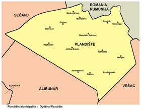
Plandište
| Plandište Пландиште | ||
|---|---|---|
| Municipality and Town | ||
|
The new Orthodox church | ||
| ||
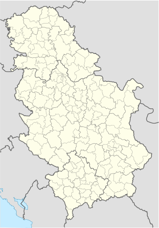 Plandište Location of Plandište within Serbia | ||
| Coordinates: 45°13′37″N 21°7′18″E / 45.22694°N 21.12167°ECoordinates: 45°13′37″N 21°7′18″E / 45.22694°N 21.12167°E | ||
| Country | Serbia | |
| Province | Vojvodina | |
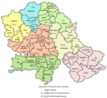
| District | South Banat | |
| Government | ||
| • Mayor | Milan Selaković | |
| Elevation | 79 m (259 ft) | |
| Population (2011) | ||
| • Plandište | 3,832 | |
| • Metro | 11,336 | |
| Time zone | CET (UTC+1) | |
| • Summer (DST) | CEST (UTC+2) | |
| Postal code | 26360 | |
| Area code(s) | +381(0)13 | |
| Car plates | VŠ | |
| Website | www.plandiste.com | |


Plandište (Serbian Cyrillic: Пландиште, pronounced [plândiːʃte]) is a village and municipality in South Banat District of Vojvodina, Serbia. The village has a population of 3,832, while Plandište municipality has 11,336 inhabitants. One of municipality's best known landmarks is Kapetanovo Castle, located in Stari Lec.
Name
In Serbian, the village is known as Пландиште or Plandište, in Romanian as Plandiște, in Hungarian as Zichyfalva, in German as Zichydorf, and in Macedonian: Пландиште.
The name of the village derived from the word "plandovati" used in the local Serbian dialect, which in modern standard Serbian means "odmarati", and in English means "to rest".
History
First data about this settlement is from the second half of the 17th century when it was mentioned under name "Morminta". In this time, settlement was populated by Serbs. After Germans were settled in this area (in 1783), settlement was expanded and named "Zičidorf". In 1805, settlement had population of 2,037 people. After World War I it was named "Mariolana" and after World War II it was named "Plandište". In the end of World War II, Germans left to Germany, while 1,919 colonists from Macedonia, other places of Vojvodina, Slovenia and Croatia settled in Plandište. Before World War I, settlement was part of Banlok municipality, and later it was part of Vršac municipality. During the 1950s, Plandište became administrative seat of its own municipality.
Source: Stevan Kovačević, Gradovi Srbije u slici i reči, Beograd, 2010.
Inhabited places
Plandište municipality includes the following villages:
- Plandište
- Banatski Sokolac
- Barice
- Velika Greda
- Veliki Gaj
- Dužine
- Jermenovci
- Kupinik
- Laudonovac
- Margita
- Markovićevo
- Miletićevo
- Stari Lec
- Hajdučica
Population
Historical population of the village:
| Historical population | |||||||||||||||||||||||||||||||||||||||||||
|---|---|---|---|---|---|---|---|---|---|---|---|---|---|---|---|---|---|---|---|---|---|---|---|---|---|---|---|---|---|---|---|---|---|---|---|---|---|---|---|---|---|---|---|
|
| ||||||||||||||||||||||||||||||||||||||||||
Ethnic groups
Ethnic groups in the municipality
According to the 2011 census, the municipality of Plandište had a total population of 11,336, including:[1]
- 5,868 Serbs (51.76%)
- 1,280 Hungarians (11.29%)
- 1,042 Macedonians (9.19%)
- 784 Romanians (7.92%)
- 616 Slovaks (5.43%)
- 281 Romani (2.48%)
- 1,465 Others and undeclared (12.92%)
Settlements by ethnic majority
Settlements with Serb ethnic majority are: Plandište, Banatski Sokolac, Velika Greda, Veliki Gaj, Dužine, Kupinik, Laudonovac, Markovićevo, Miletićevo, and Stari Lec. The settlement with Romanian ethnic majority is Barice. The settlement with Hungarian ethnic majority is Jermenovci. Ethnically mixed settlement with relative Serb majority is Margita. Ethnically mixed settlement with relative Slovak majority is Hajdučica.
Ethnic groups in the village
| Year | Total | Serbs | Macedonians | Yugoslavs | Hungarians | Romanians | Slovaks | Montenegrins | Unknown |
|---|---|---|---|---|---|---|---|---|---|
| 1991 | 4,380 | 54.84% | 23.69% | 9.2% | 5.57% | 1.57% | 0.82% | 0.66% | 3.65% |
| 2002 | 4,270 | 59.46% | 21.31% | 3.93% | 5.69% | 1.7% | 0.96% | 0.42% | 6.53% |
See also
- List of places in Serbia
- List of cities, towns and villages in Vojvodina
- Municipalities of Serbia
- South Banat District
References
- ↑ "Population by ethnicity – Plandište". Statistical Office of the Republic of Serbia (SORS). Retrieved 4 March 2013.
Gallery
 The center of the village and the Catholic Church
 Kapetanovo Castle
| Wikimedia Commons has media related to Plandište. |